|
 |
 |
 |
 |
 |
 |
 |
 |
 |
 |
 |
 |
 |
 |
 |
 |
 |
 |
 |
 |
 |
 |
 |
 |
 |
 |
 |
 |
 |
 |
 |
 |
 |
 |
 |
 |
 |
 |
 |
 |
 |
 |
 |
 |
 |
 |
 |
 |
 |
 |
 |
 |
 |
 |
 |
 |
 |
 |
 |
 |
 |
 |
 |
 |
 |
 |
 |
 |
 |
 |
 |
 |
 |
 |
 |
 |
 |
 |
 |
 |
 |
 |
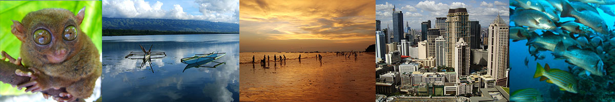
Philippines
Corregidor
Corregidor is an island in the entrance of the Philippines' Manila Bay. Due to its position in the bay, it has served as a focal point for the naval defenses of the capital city of Manila. During World War II, Corregidor was the site of several battles and its fall to the Japanese forces was instrumental in the subsequent capture of the Philippines and the retreat of the United States in the early stages of the war. Currently, it is an important historic and tourist site and is managed under the jurisdiction of Cavite City.
Geography
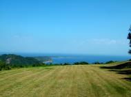
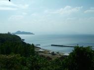
The island is about 48 kilometers west of Manila. It is shaped like a tadpole, with its tail running eastward, and has a land area of 9 km�. Along with Caballo (which lies 2 km south of the 'tail's' tip), it partially blocks the entrance to Manila Bay, and thus has strategic importance. It also creates a northern and southern entrance to the bay.
Because of its rocky landscape and the fortifications of Fort Mills, the island was also known as 'the Rock'.
Geologically the island is a remnant of a volcano, Corregidor Caldera, last active about 1 million years ago. Philippine Institute of Volcanology and Seismology regards it as a potentially active volcano.
Corregidor is four miles (6 km) long and about 1.5 miles (2.4 km) at its widest point, with a total area roughly about three square miles. Its bulbous head, which points towards the South China Sea rises prominently to a large flat called Topside. This was the nerve center of the Island and here was located the headquarters, barracks for enlisted personnel, a branch of the Philippine Trust Co. bank, the Cine movie theater, officers' quarters, underground ordnance shops, the traditional parade grounds, an Officers' Club with a 9 hole Golf Course , tennis courts, and swimming pool, and the bulk of the batteries that constituted the strength of Corregidor.
Middleside
Middleside is a small plateau that interrupts the upward slope from Bottomside to Topside, and was the location of 2-story officers' quarters, barracks for the enlisted men, a hospital, quarters for non-commissioned officers, a service club, PX, and two schoolhouses�one for the children of Filipino soldiers and the other for American children.
Bottomside
Bottomside is the lower part of the island and is the neck that connects the tail and head of the island. South of Bottomside is Barrio San Jos� (near what was Navy Beach); on the north is what was Army Dock, with its three large piers, and, east of Bottomside, is Malinta Tunnel.
Under the Spanish era, Corregidor served not only as a fortress of defense and a penal institution, but also as a signal outpost to warn Manila of the approach of hostile ships, and as a station for Customs inspection. Corregidor comes from the Spanish word corregir, meaning 'to correct.' One story states that, due to the Spanish system wherein all ships entering Manila Bay were required to stop and have their documents checked and corrected, the island was called Isla del Corregidor (literally, Island of Correction). Another version claims that the island was used a penitentiary or correctional institution by the Spanish and came to be called El Corregidor.
Twentieth Century
In 1902, the island was organized as an American military reservation. In 1903, a convalescent hospital was established by the United States Army.
In 1908, a Regular Army post was established on the island, designated as Fort Mills, in honor of Brigadier General Samuel Meyers Mills, Jr., Chief of Artillery of the U.S. Army from 1905 to 1906. By early 1909, H Company of the 2nd Battalion of the Corps of Engineers was assigned to Corregidor and started on the construction of concrete emplacements, bomb-proof shelters, and trails at various parts of the island. This pioneer engineer company left Fort Mills on March 15, 1912.
The defense of Corregidor was the immediate responsibility of the Philippine Coast Artillery Command under Major General George F. Moore. Stationed on the island were the following regular units:
* 59th Coast Artillery (U.S. Regular Army)
* 60th Coast Artillery AA (U.S. Regular Army)
* 91st Coast Artillery (Philippine Scouts)
* 92nd Tractor Drawn Coast Artillery (Philippine Scouts)
* Headquarters, Harbor Defenses of Manila and the Seaward Defense Command.After the outbreak of World War II, the island was reinforced by mobilized Philippine Army troops, and in April 1942, one Battalion of the Fourth Marines, which were sent to reinforce the island's beach defenses.
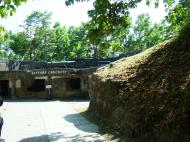
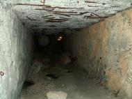
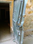
The Army post on Corregidor was named Fort Mills, that on Caballo Island, Fort Hughes, on El Fraile, Fort Drum, and on Carabao Island, Fort Frank. According to the war plan, these forts were supposed to be able to make a six-month stand, after which aid would presumably come from the United States. The fortifications on Corregidor were designed solely to beat off a seaborne attack. When American military planners realized that airplanes would one day render Fort Mills obsolete, the United States was restricted from improving the fortifications by the Washington Naval Treaty of 1922. After this, the U.S. Army constructed the Malinta Tunnel, with its series of related laterals, to protect its military stores and vital installations in the event of war.
The island, which sheltered Fort Mills, was a prized piece of real estate. Its defense installations had cost the U.S. government more than 150 million dollars. This amount did not include the expenditure for fortifying the neighboring islands of Caballo, Carabao, and El Fraile.
Corregidor during World War II
During the Battle of the Philippines (1941�42), General Douglas MacArthur used Corregidor as Allied headquarters until March 11, 1942. Between December 24, 1941 and February 19, 1942, it was also the temporary location of the Government of the Commonwealth of the Philippines�on December 30, 1941, outside the Malinta Tunnel, President Manuel L. Quezon and Vice-President Sergio Osme�a were inaugurated for a second term. The Voice of Freedom, the radio station of the USAFFE (United States Army Forces in the Far East) broadcast from Corregidor, including the famous announcement of the fall of Bataan. Japanese troops forced a surrender of the remaining American and Filipino forces on Corregidor on May 6 after the Battle of Corregidor.
Battle of Corregidor
The Battle for Corregidor was the culmination of the Japanese campaign for the conquest of the Philippines. The fall of Bataan in April 9, 1942 ended all organized opposition by the U.S. Armed Forces in the Far East (USAFFE) to the invading Japanese forces on Luzon in the northern Philippines. The island bastion of Corregidor, with its network of tunnels and formidable array of defensive armament, along with the fortifications across the entrance to Manila Bay, was the remaining obstacle to the 14th Japanese Imperial Army of Lieutenant General Masaharu Homma. The Japanese had to take Corregidor; as long as the island remained in American hands, they would be denied the use of the Manila Bay, the finest natural harbor in the Orient.
The Battle for the Recapture of Corregidor, between 16 February and 26 February 1945, by American and Filipino liberation forces against the defending Japanese garrison on the island fortress used by the USAFFE, which was the last bastion to surrender to invading Japanese forces in 1942.
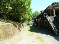
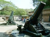
Fortifications
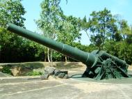
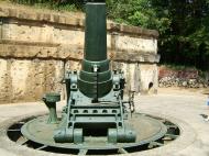
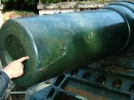
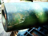
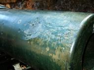
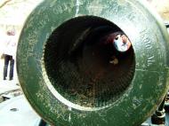
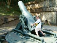
There were 23 batteries installed on Corregidor, consisting of 56 coastal guns and mortars. In addition, Corregidor had 13 anti-aircraft artillery batteries with 76 guns (28 3-inch and 48 .50-caliber) and 10 60-inch Sperry searchlights.
The longest-range coastal pieces were the two 12-inch (305 mm) guns of Batteries Hearn and Smith, with a horizontal range of 29,000 yards (27,000 m). Although capable of an all around traverse, these guns, due to their flat trajectories, were not effective for use against targets on Bataan.
During the siege, the island had ample armor-piercing ammunition but very little of the anti-personnel type, which then was of greatest demand for use against land targets on Bataan. In fact, most of the anti-personnel shells were only for the 12-inch mortars of Batteries Way and Geary.
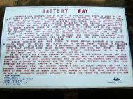
Battery Way
Battery Way was named in honor of the Coast Artillery Corps of the U.S. Army, which along with Battery Geary, was the mainstay of the Corregidor Garrison during the Japanese invasion. Its mortars, capable of a 360-degree traverse, could fire on land targets at Bataan. They brought the most destruction on Japanese positions during the attempted landings on the southwest coast of Bataan late in January to the middle of February 1942. These mortars were silenced by enemy shelling in May 1942.
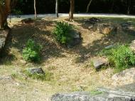
Battery Geary
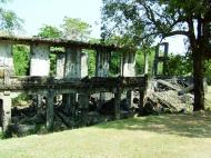
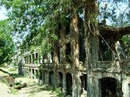
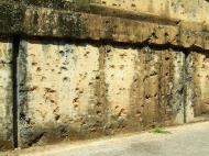
Battery Geary was a battery of eight 13-ton, 12-inch mortars. This battery, when pinpointed by the Japanese, was subjected to heavy shelling. One direct hit by a 240-mm shell, which detonated the magazines of this battery in May 1942, proved to be the most crippling shot during the entire siege of Corregidor. This shelling tossed the mortars around, one to a distance of 150 yards (140 m), another was blown through three feet of reinforced concrete wall into the adjoining powder magazine of Battery Crockett. Large chunks of steel were blown as far as the Malinta Tunnel, killing 27 of the battery crew instantly. Also, one mortar still had a live round in its breech, and it was in the process of firing the shell when the magazine was hit.
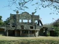
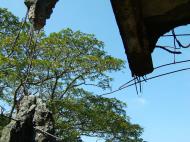
Other facts
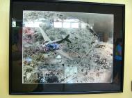
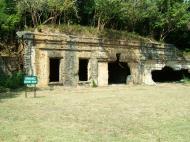
Aerial view of the ruins
* Before the war and during the siege, Corregidor depended mostly for its potable water on Bataan. For this purpose, barges were used to haul water either from Mariveles or Cabcaben, Bataan.
* There were 65 miles (105 km) of paved roads and trails on the island and 19.5 miles (31.4 km) of electric railroad track. The latter were used largely to haul heavy equipment and ammunition from Bottomside to the different Batteries. The Corregidor High School was where children, of both Filipino and American servicemen assigned on the island, studied. The island also had an electric trolley system as public transport, a movie house (Cine Corregidor), a baseball field and a swimming pool. The business and social center of this community was found on Topside.
* On the island was Kindley Airfield. It was named in honor of an early hero of the U.S. Army Air Corps. It was a pre-war installation developed in the early-1920s and was rendered useless by hostile aerial bombardment in the early days of the war.
* The lighthouse is one of the oldest landmarks in Corregidor. A lighthouse with a beam range of 33 miles (53 km). It was first built by the Spaniards in 1836 and was replaced with a better one in 1853. The second lighthouse was further improved in 1892 and was reduced to ruins during the siege of Corregidor. This rehabilitated lighthouse stands on the same spot where the second lighthouse stood before.Pacific War Memorial
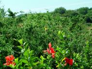
After the War, many people, most of them veterans, visited the island because of its history. Today, Corregidor is a historic monument as well as a tourist destination. Many travel companies offer day tours on the island featuring military installations used during World War II. Most of the war-ravaged buildings have not been restored, but have instead been left in reverence to the Filipino and American soldiers who died there. Standing on the highest part of Corregidor's west side is the Pacific War Memorial, which was built by the United States Government to honor the Filipino and American soldiers who participated in World War II. It was completed in 1968 at the cost of three million dollars.
The Malinta Tunnel, which is the last stronghold of the joint Philippine and American military prior to the Japanese takeover during the last world war, is now home to an audio-visual presentation by National Artist Lamberto V. Avellana of the events that took place on the island, including the reluctant departure of General Douglas MacArthur and the evacuation of the Philippine president Manuel L. Quezon and his family to unoccupied areas of the Philippines and then to exile in the United States.
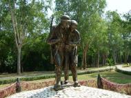
One of the most recent additions to Corregidor is the Filipino Heroes Memorial. This 6,000-square meter complex has 14 murals depicting heroic battles fought by Filipinos from the 15th century up to the present day. It was designed by Francisco Ma�osa, while the murals and a statue of a Filipino guerrilla were sculpted by Manuel Casas. The complex was inaugurated by President Fidel V. Ramos on August 28, 1992.
Once every May 6 at exactly noon, sunlight falls on the center of the altar and visitors are required to have a moment of silence since this is the exact moment that Corregidor and the Philippines fell into the hands of the Japanese.
Manila Bay
Manila Bay is a natural harbor which serves the Port of Manila (on Luzon), in the Philippines. The bay is considered to be one of the best natural harbors in Southeast Asia and one of the finest in the world. It has an area of 1,994 km2 (769.9 sq mi), and a coastline of 190 km (118.1 mi). The entrance is 19 km (11.8 mi) wide and expands to a width of 48 km (29.8 mi). Corregidor Island divides the entrance into two channels, about 2 miles (3.2 km) towards the North and 6.5 miles (10.5 km) wide on the South side. Mariveles, in the province of Bataan, is an anchorage just inside the northern entrance and Sangley Point is the former location of Cavite Naval Base.
On either side of the bay are volcanic peaks topped with tropical foliage: 40 km to the north is the Bataan Peninsula and to the south is the province of Cavite.
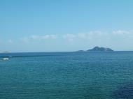
Across the entrance to Manila Bay are several islands. The largest is Corregidor, which is 3 kilometers from Bataan and, along with the island of Caballo, separates the mouth of the bay into the North and South Channels. In the south channel is El Fraile Island and outside the entrance, and to the south, is Carabao Island. El Fraile, a rocky island some 4 acres (1.6 ha) in area, supports the massive concrete and steel ruins of Fort Drum, an island fortress constructed by the United States Army to defend the southern entrance of the bay. To the immediate north and south are additional harbors.
The bay was the setting for the Battle of Manila Bay in 1898 and the siege of Corregidor Island by invading Japanese forces in 1942.
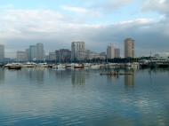
Manila Bay drains approximately 17,000 km2 (6,563.7 sq mi) of watershed area, with the Pampanga River contributing about 49% of the freshwater influx. With an average depth of 17 m (55.8 ft), it is estimated to have a total volume of 28.9 billion cubic meters (28.9 cubic km). Today, Manila Bay still remains important for commerce and industry, including fishing, although rapid urban growth and industrialization are contributing to a decline in water quality and deteriorating marine habitats. It also serves a focus for recreation for Metro Manila and is a popular destination for walks and for viewing the sunset. Much of the land fronting the bay along Metro Manila is reclaimed land which now includes important sites such as the Philippine Senate and the Mall of Asia.
Web References:
http://en.wikipedia.org/wiki/Manila_Bay
http://en.wikipedia.org/wiki/Corregidor
http://en.wikipedia.org/wiki/File:Corregidor_DN-ST-86-01667.JPEG
 Editor for Asisbiz: Matthew Laird Acred
If you love our website please add a like on facebook
Please donate so we can make this site even better !!