|
 |
 |
 |
 |
 |
 |
 |
 |
 |
 |
 |
 |
 |
 |
 |
 |
 |
 |
 |
 |
 |
 |
 |
 |
 |
 |
 |
 |
 |
 |
 |
 |
 |
 |
 |
 |
 |
 |
 |
 |
 |
 |
 |
 |
 |
 |
 |
 |
 |
 |
 |
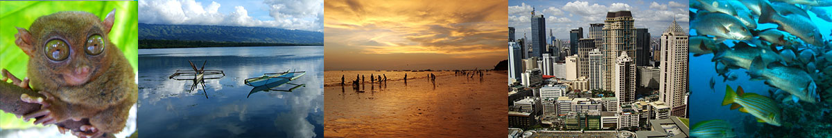
Philippines
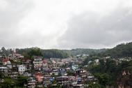
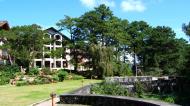
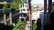
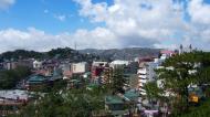
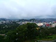
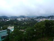
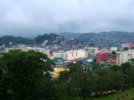
Baguio
The City of Baguio (Ilokano: Ciudad ti Baguio; Tagalog: Lungsod ng Baguio) is a highly urbanized city in northern Luzon in the Philippines. Baguio City was established by Americans in 1900 at the site of an Ibaloi village known as Kafagway. Baguio City was designated by the Philippine Commission as the Summer Capital of the Philippines on June 1, 1903 and incorporated as a city by the Philippine Assembly on September 1, 1909. Baguio is the seat of government of the Cordillera Administrative Region. The name of the city is derived from the word bagiw in Ibaloi, the indigenous language of the Benguet Region, meaning 'moss'. The city is at an altitude of approximately 1500 meters (5100 ft) in a moist tropical pine forest conducive to the growth of mossy plants and orchids.
According to the 2007 census, Baguio City has a population of 301,926.
The City of Baguio celebrated its Centennial on September 1, 2009. The celebrations marked the first 100 years of the Baguio City Charter, which was authored by former Philippines Supreme Court Justice George A. Malcolm.
Geography
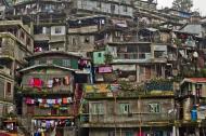
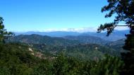
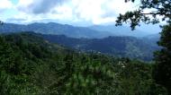
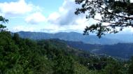
Baguio City is located some 1,500 meters above sea level, nestled within the Cordillera Central mountain range in Northern Luzon. The city is enclosed by the province of Benguet. It covers a small area of 57.5 square kilometers. Most of the developed part of the city is built on uneven, hilly terrain of the northern section. When Daniel Burnham plotted the plans for the city, he made the City Hall as a reference point where the city limits extend 8.2 kilometers from East to West and 7.2 kilometers from North to South.
The city of is known for its mild climate. It is because of this that Baguio is nicknamed the 'Summer Capital of the Philippines'. Owing to its high elevation, the temperature in the city is 8 degrees Celsius lower compared to the average temperature of the rest of the country. Average temperature ranges from 15 to 23 degrees Celsius. It is usually lower during the late and early months of the year. The lowest recorded temperature was 6.3 degrees Celsius on January 18, 1961. This is in contrast to the all-time high of 30.4 degrees Celsius recorded on March 15, 1988 during the 1988 El Nino season. Baguio seldom exceeds 26 degrees Celsius even during the warmest part of the year.
Transportation
Air transport
Loakan Airport is the lone airport serving the general area of Baguio City. The airport is classified as a trunkline airport, or a major commercial domestic airport, by the Civil Aviation Authority of the Philippines, a body of the Department of Transportation and Communications that is responsible for the operations of not only this airport but also of all other airports in the Philippines except the major international airports. It is about 10 minutes by car from the city center going south. Due to the limited length of the runway which is 1,802 meters or 5,912 feet, it is restricted to commuter size aircraft. This perhaps contributed to the city's declining competitiveness against other medium-sized cities around the country. The airport is used primarily by helicopters, turbo-prop and piston engine aircraft, although on rare occasion light business jets (LBJ) have flown into the airport.
Land Transport
The three main access roads leading to Baguio from the lowlands are Kennon Road, Aspiras-Palispis Highway (formerly Marcos Highway), and Naguilian Road also known as Quirino Highway. Kennon Road starts from Rosario, La Union and winds through a narrow, steep valley. This is the fastest route to Baguio but is perilous, with landslides during the rainy season. This route to Baguio is as scenic as it is dangerous. Aspiras Highway, which starts from Agoo, La Union and connects to Palispis Highway at the boundary of Benguet and La Union, and Naguilian Road, which starts from Bauang, La Union, are longer routes but are safer than Kennon Road and are the preferred routes for coaches, buses and lorries.
It takes an average of six hours to travel the 250 km distance between Manila and Baguio by way of Kennon Road. It is about fifteen minutes longer through the Aspiras-Palispis Highway and could take three more hours when going through Naguilian Road, which is the usual route for travellers from the North.
There is another access to Baguio from Aritao in the province of Nueva Vizcaya passing through Itogon, Benguet but this is less traveled, the road is not well maintained, and public transportation through this route is not as regular. Another road, Halsema Highway (also known as 'Mountain Trail') leads north through the mountainous portion of the Cordillera Autonomous Region. It starts at the northern border of Baguio, in the Municipality of La Trinidad (Trinidad Valley).
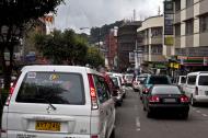
There are several bus lines linking Baguio with Manila and Central Luzon, and provinces such as Pangasinan, La Union, and those in the Ilocos region. Most transportation companies also offer express and air-conditioned buses at a much higher fare, though some minibuses offer cheaper fares. Bus services that operates in Baguio include Philippine Rabbit, Dangwa Tranco, Dagupan Bus, Viron,Victory Liner, Partas, Genesis, and Saulog Transit.
There are also several taxi and Jeepney operators that provide easy transportation within the city.
Economy
The economy of Baguio City is centered on its educational institutions, of which it has in excess of eight colleges and universities as well as a plethora of trade and technical schools. Based on the latest census made in the year 2007, almost half of the city's population are students in which most of them come from nearby provinces.
Another key source of income for Baguio is its character as the commercial hub in the province of Benguet. Many of the agricultural and mining goods produced in Benguet go to Baguio City for processing and central distribution.
The city is also a major retail center for the Cordilleras and Ilocos provinces, with shoppers coming to the city to take advantage of the diversity of competitively priced commercial products on sale, many of which would only be available in Manila. Despite the city's relatively small size, it hosts numerous shopping centers and malls catering to the increasing commercial and tourist activity in Baguio: these include SM City Baguio mall, Baguio Center Mall, Cooyeesan Hotel Plaza, Abanao Square, Maharlika Livelihood Center, Porta Vaga Mall and Bonchic bargain center.
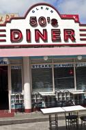
Various food and retail businesses run by local residents proliferate, serving to form what has become a part of Baguio's local cultural landscape. Some of these include the Tiong San chain of department stores and supermarkets, Sunshine Supermarket, Star Cafe, Country Mart, the famous Rose Bowl Restaurant, Good Taste, Marosan's, Patao's and many others.
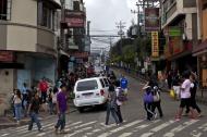
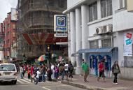
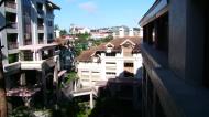
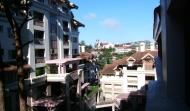
Session RoadThe areas of Session Road, Harrison Road, Magsaysay Avenue and Abanao Street comprise the trade center of the city. It is in these areas where commercial and business structures abound. First-class cinemas, hotels, restaurants, department stores, and shopping centers are to be found in this area. Shopping at the famous City Market offers one a wide array of locally sourced goods and products: everything from colorful woven fabrics and hand-strung beads to primitive wood carvings, cut flowers, strawberries and 'Baguio' vegetables, the latter often denoting vegetable types that do well in the cooler growing climate. (Strawberries and string beans�referred to as 'Baguio beans' across the Philippines�are shipped to major urban markets across the archipelago.)
Baguio is also home to one of the country's most profitable Philippine Economic Zone Authority areas (PEZA), called the Baguio City Economic Zone (BCEZ), located in the southern part of the city between the Camp John Hay leisure resort and the Philippine Military Academy. Firms located in the BCEZ mostly produce and export knitted clothing, transistors, small components for vehicles, electronics and other computer parts. Notable firms include Texas Instruments Philippines, MOOG, and Sitel.
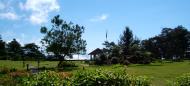
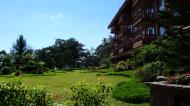
TourismTourism is one of Baguio's main industries. During the year end holidays some people from the lowlands would prefer spending their vacation in the city. This is for them to experience the cold temperature they rarely get from their home provinces. Also, during the summer season specially during the Holy Week, tourists from all over the country would flock to the city. During this time, the total number of people in the city would double. To accommodate all these people, there are more than 80 hotels and inns available for them to check in. There are also some local residents that accept transients for a certain fee which is normally lower than the standard hotel fee. For those who can't afford renting a room, they would camp out in some local parks although this is no longer allowed to prevent the parks from getting damaged. Local festivities such as the Panagbenga Festival also attracts both local and foreign tourists.
Tourist Attractions
Lion's Head Located in Camp 6 Kennon Road, this popular landmark was constructed in 1972 with the contributions of the Lions Club International members in Baguio. This 40-foot head of a lion was carved in a limestone by a local artist. Visitors passing by normally stop for a while to have a break and to take photographs as souvenir.
Tam-awan Village This artificial village was founded by Chanum Foundation, Inc. in 1998. It was constructed with the purpose of showing visitors how a local village in the highlands look like. Authentic native huts where brought from the Mt. Provinces and are rented out to those who wish to stay overnight and experience the way locals once lived. A gallery was also constructed to house the paintings and other artworks created by several local artists. The word 'tam-awan' means 'a high place to view'. With clear weather conditions, one can see the South China Sea and the Lingayen Gulf. This is also a good place to view the sun set.
Philippine Military Academy Situated in the southern part of the city within Fort Del Pilar, Loakan, this military academy was created to train future officers of the Armed Forces of the Philippines.
Mansion House As an official residence of the President of the Republic of the Philippines, entry to the compound is restricted. The public can view the Mansion through its gate which is patterned after that of London's Buckingham Palace. It is located in the eastern part of the city. The Mansion has also been the site of several international conferences and a working office of the President of the Philippines during his or her visits to the City.
Camp John Hay This former American recreational facility was converted into as a world class resort. It features a golf course, a skating rink, picnic area, and a mini golf course at the Scout Hill area. Several cottages and hotels were also built to accommodate visitors.
Teachers Camp A facility currently run by the Department of Education. I features several function halls, a museum, cottages, and a race track.
Easter Weaving Room Located within the campus of Easter School. It is the right place to visit for those who are interested in native fabrics and other handicrafts. Here one can witness the actual process of cloth weaving as practiced by the natives of the Mountain Provinces for ages.
Saint Louis Filigree Shop This is a handicraft shop specializing in silver jewelry and other filigree products. This shop is in the center of the city and was established in 1916.
Wright Park It is sometimes mistakenly called 'Ride Park' by some tourists that identify this pine tree park reserve for horse rides. A long stairway leads to the 'Pool of the Pines', a 100 meter long pool of water lined on both sides by the famous Baguio towering pine.
Mines View Park Appropriately named for its view of Benguet's mountain ranges where gold, silver and other ores were once quarried.
Baguio Sunshine Park The park features flowering garden and a covered stage with ethnic design, which is often used, for cultural presentation. The park itself is designed after a shield.
Botanical Garden It is also called the Igorot village, which features native huts typical of the Cordillera architecture. The garden is also a site of cultural presentations and other tribal meetings.
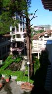
Burnham Park It is the oldest of all Baguio parks. One can unwind from the tension of the day-to-day bustle by biking, skating or simply reflecting on the day's experiences amid a soothing garden backdrop of colorful flowers. It is thickly wooded and is a great place to have picnics and concerts. There are tennis and basketball courts, a football field, athletic oval and an orchidarium.
Baguio - Mountain Provinces Museum This museum is located within the Baguio Tourism Complex along Gov. Pack Road. It has on display a variety of artifacts and relics showcases the cultural heritage, customs and traditions of the mountain provinces.
SLU (Saint Louis University, Baguio City) Museum Located within the premise of the school, it showcases the different culture heritages of the Cordilleras. Artifacts and relics including an ancient coffin can be seen on display.
Ifugao Woodcarvers Village Located along Asin Road, about 5 kilometers from the city, is an Ifugao wood carving village, which produces and sells hand-carved curio items.
Asin Hot Springs These hot springs are located 16 kilometers northwest of Baguio. Several private resorts took advantage of the natural springs in the area and constructed swimming pools for all visitors. Some of the resort owners also built cottages for those who wish to spend the night.
Mt. Sto. Tomas and Mt. Kabuyao A trek up to these mountains is a hiker delight. The highest peak is 7,500 feet high and commands a majestic view of the city. These mountains can be reached by foot or by vehicle.
Lourdes Grotto This is a religious shrine housing the image of the Lady of Lourdes. About 252 steps lead to this shrine where pilgrims brave the steep climb to offer sacrifices, devotion and prayers. One is also regarded with a beautiful panoramic view of the city.
Baguio Cathedral One of the familiar landmarks in Baguio, the structure with its twin spires and one hundred steps sits on top of a hill in the heart of the city, offering church goers and visitors a chance to get a bird's eye view of the entire commercial hub.
Bell Church This cluster of temples is located on the border of Baguio City and Trinidad Valley. Its exotic oriental architecture, pagodas roof, ornate gateway, dragon ornaments and Buddha - guarded windows gaze from atop a hill. The Bell Temple priest practices a mixture of Buddhism, Taoism, Confucianism, and Christianity. One may even try having his fortune told.
Baguio Grand Mosque Muslims may pray in any of the several Mosques in the City but this is the biggest and located at Campo Filipino. It also houses an Islamic Studies madrasah. Visits or field trips by non-Muslims may be arranged.
Baguio Country Club This club was organized with funds, which were privately contributed. They built tennis courts and cottages. Today Baguio Country Club has 200 guestrooms and suites in a new building. It also boasts a beautiful 18-hole, 61-par golf course for its members and guests.
Baguio City Market Located within the central business district, this is where local products and goods from nearby towns and provinces are sold.
EducationBaguio is a university town with 141,088 students out of the 301,926 2007 population count. It is the center of education in the entire North Luzon. There are eight major institutions of higher education in Baguio City.
U.P. Baguio OblationUniversity of the Philippines Baguio (U.P. Baguio) - the national university of the Philippines, U.P. System's flag-bearer in Northern Luzon, internationally known for its excellent record in ethnic and multidisciplinary research and Cordillera Studies
Philippine Military Academy - the national training school for future officers of the Armed Forces of the Philippines
Saint Louis University, Baguio City - established in 1911 by the CICM missionaries whose aim is to educate the locals through Christian Education.
University of Baguio - founded by Dr. Fernando G. Bautista and Mrs. Rosa C. Bautista in 1948.
University of the Cordilleras - formerly Baguio Colleges Foundation, established on June 19, 1948.
Baguio Central University- formerly Lyceum of Baguio. First opened in 1945.
Pines City Colleges - formerly Pines City Doctors' Hospital School of Nursing and Pines City Educational Center. First opened as a Nursing school in 1969. The oldest school of Nursing in Baguio City.
Easter College - formerly Easter School and first school in the Cordilleras which opened in 1906.
Philippine Baptist Theological Seminary is the flagship Southern Baptist ministerial training center established in 1954, offering undergraduate, graduate and post graduate degree programs.
Asia Pacific Theological Seminary founded in 1964 in Manila and transferred to the Baguio area in 1986, is the foremost seminary for the Asia-Pacific region of the Assembles of God.
Lutheran Theological Seminary was established in 1955 in Manila with the Rev. Lorenz Nieting as head. The campus was moved to Baguio in 1961 offering a five-year divinity degree program leading to ordination to Lutheran diaconate on the third year and the priesthood.
Baguio is also home to Brent International School, which was founded the same year as the city. It was originally established as a boarding school for the sons of American families stationed in the Philippines.
Several technical schools also found roots in the city, in addition to a number of primary and secondary schools. They also contributed to the growing population of students in the city.
Culture
The city is home to people coming from other places. It became a melting pot of cultures and traditions from all over the country. A significant population of foreigners also contributed to the diversity of the city's colorful culture. The languages commonly spoken in Baguio are Kankana-ey, Ibaloi, Ilocano, Tagalog, Kapampangan, Pangasinan, English, Chinese, and recently, Korean. Due to a significantly large number of Korean students coming to the city to study the English language, several establishments were founded to accommodate their needs. Posters and signages are sometimes printed with Korean translation. Several restaurants also serve different types of local and foreign cousine.
Baguio's youth majority in the population has given it a distinct flavor different from those of other cities in the Philippines. Although Baguio City is very modern nowadays, Panagbenga Festival, the annual Flower Festival, is celebrated each February to showcase Baguio's rich cultural heritage, its appreciation of the environment, and inclination towards the arts.
HistoryThe region around Baguio was first settled primarily by the Kankana-eys and the Ibalois. In the nearby town of La Trinidad, Spaniards established a commandante or military garrison, although Kafagway, as Baguio was once known, was barely touched. In 1901 Japanese and Filipino workers hired by the Americans built Kennon Road, the first road directly connecting Kafagway with the lowlands of Pangasinan. Before this, the only road to Kafagway was Naguilian Road. On September 1, 1909 Baguio was declared a chartered city. The famous American architect Daniel Burnham, one of the earliest successful modern city planners, laid a meticulous plan for the city in 1904. His plan was, nevertheless, realized only to a small extent, primarily due to growth of the city well beyond its initial planned population of 25,000 people. The Americans earlier declared Baguio the Summer Capital of the Philippines on July 1, 1903 and The American Residence as the residence of the American governor-general to escape Manila's summer heat. They further developed Baguio, building parks and public structures such as Wright Park in honor of Governor General Luke E. Wright, Burnham Park in honor of Baguio city planner Daniel Burnham, Governor Pack Road, and Session Road.
Baguio is well known as site of the formal surrender of General Tomoyuki Yamashita and Vice Admiral Okochi. It is where they gave up the entire Imperial Japanese Armed Forces to American authorities at the High Commissioner's Residence (now the United States Ambassador's Residence) in Camp John Hay on September 3, 1945, marking the end of World War II.
A strong earthquake destroyed most of Baguio on July 16, 1990. The city was quickly rebuilt, thanks to the aid of the national government and various international donors like Japan, Singapore and other neighboring countries.
Around May 2003, a petition initiated by Dion Fernandez to declare Baguio a heritage zone was circulated on the Internet and national print media, gaining more than 10,000 signatures. The petition calls upon unspecified officials to create the Zone prior to the Baguio centennial in 2009. In May 2005, the Heritage Conservation Society(HCS) submitted to the Baguio City Council a proposed Special Heritage Bill drafted by HCS Trustee Ivan Henares. It has been approved on second reading but is being opposed by a group of businessmen.
Art
The city became a haven for many Filipino artists in the 1970s-1990s. Drawn by the cool climate and low cost of living, artists such as Ben Cabrera (now a National Artist) and filmmaker Butch Perez relocated to the city. At the same time, locals such as mixed-media artist Santiago Bose and filmmaker Kidlat Tahimik were also establishing work in the city.
Many Baguio artists used the context of cultural diversity of the Cordillera Region to establish their work. Other notable Baguio City artists include Narda Capuyan (weaving), Kawayan de Guia (painting), Kigao (sculpture), Willy Magtibay, Peter Pinder (fiber glass sculpture, painting, mixed media), Art Tibaldo (mixed media-visual arts) and Franklin Cimatu (poetry.) The active student population in Baguio has also spawned various interests in animation and digital arts, with several local artists doing work for large production and advertising agencies in the Philippines and abroad.
Government
Like most Philippine cities, Baguio is governed by a Mayor, Vice Mayor, and twelve (12) Councilors. However, being a highly-urbanized city, it is not subject to the jurisdiction of Benguet, the province which it was formerly part of.
The current mayor of Baguio is Reinaldo Bautista Jr. who first assumed office after the suspension of Braulio Yaranon in August 2006. Yaranon's term was clouded in controversy, primarily because of his harsh attacks on previous city officials who initiated the scandalous Uniwide Market Project, Jadewell Parking Systems Project, the now finished 172 million, 274-meter BGH flyover project, and the proposed operation of a Casino inside Camp John Hay. The Jadewell Parking System was approved by the city council in 2000 and then City Mayor Mr. Mauricio Domogan. The parking firm's owners filed administrative charges against Yaranon for his stand against its operation. He was eventually suspended until the end of his term on June 30, 2007.
Bautista recently had his 'interim/acting' tag removed from his title as he emerged as the winner in the 2007 city mayoral race, beating Yaranon, Vergara, former Councilor Leandro Yangot Jr. and post-People Power mayor and spiritual healer Ramon 'Jun' Labo Jr. His running mate, three-term vice mayor and law dean Daniel Fari�as, returned to that post as well after previously serving a term in the City Council.
Baguio City's lone congressional district is currently represented in the House of Representatives of the Philippines by Congressman Mauricio Domogan, who is now in his third successive term. Prior to being elected as congressman in 2001, he served three straight terms as mayor(1992-2001).
City Officials (2007-2010)* Congress Representative: Mauricio Domogan
* City Mayor: Reinaldo Bautista Jr.
* City Vice Mayor: Daniel Fari�as
* Councilors:
o Rocky Thomas Balisong
o Betty Lourdes Tabanda
o Galo Weygan
o Perlita Chan-Rondez
o Nicasio Aliping
o Antonio Tabora Jr.
o Erdolfo Balajadia
o Nicasio Palaganas
o Isabelo Cosalan Jr.
o Richard Cari�o
o Fred Bagbagen
o Elaine Sembrano
o Joel Alangsab (Ex-officio; Liga ng mga Barangay President)
o Ysa De Vera (Ex-officio; Sangguniang Kabataan Federation President)Barangays
Baguio City is politically subdivided into 129 barangays.
* Apugan-Loakan
* Asin Road (Asin Hotsprings)
* Atok Trail
* Bakakeng Central
* Bakakeng North
* Happy Hollow
* Balsigan
* Bayan Park West
* Bayan Park East
* Brookspoint
* Brookside
* Cabinet Hill-Teacher's Camp
* Camp Allen
* Camp 7
* Camp 8
* Campo Filipino
* City Camp Central
* City Camp Proper
* Country Club Village
* Cresencia Village
* Dagsian, Upper
* DPS Area
* Dizon Subdivision
* East Quirino Hill
* Engineers' Hill
* Fairview Village
* Fort del Pilar
* General Luna, Upper
* General Luna, Lower
* Gibraltar
* Greenwater Village
* Guisad Central
* Guisad Sorong
* Hillside
* Holy Ghost Extension
* Holy Ghost Proper
* Imelda Village
* Irisan
* Kayang Extension
* Kias
* Kagitingan
* Loakan Proper
* Lopez Jaena
* Lourdes Subdivision Extension
* Dagsian, Lower
* Lourdes Subdivision, Lower
* Lower Quirino Hill
* General Emilio F. Aguinaldo
* Lualhati
* Lucnab
* Magsaysay, Lower
* Magsaysay Private Road
* Aurora Hill Proper
* Bal-Marcoville
* Middle Quirino Hill
* Military Cut-off
* Mines View Park
* Modern Site, East
* Modern Site, West
* New Lucban
* Aurora Hill, North Central
* Sanitary Camp, North
* Outlook Drive
* Pacdal
* Pinget
* Pinsao Pilot Project
* Pinsao Proper
* Puliwes
* Pucsusan
* MRR-Queen Of Peace
* Rock Quarry, Lower
* Salud Mitra
* San Antonio Village
* San Luis Village
* San Roque Village
* San Vicente
* Santa Escolastica
* Santo Rosario
* Santo Tomas School Area
* Santo Tomas Proper
* Scout Barrio
* Session Road Area
* Slaughter House Area
* Sanitary Camp South
* Saint Joseph Village
* Teodora Alonzo
* Trancoville
* Rock Quarry, Upper
* Victoria Village
* West Quirino Hill
* Andres Bonifacio
* Legarda-Burnham-Kisad
* Imelda R. Marcos
* Lourdes Subdivision, Proper
* Quirino-Magsaysay, Upper
* A. Bonifacio-Caguioa-Rimando
* Ambiong
* Aurora Hill, South Central
* Abanao-Zandueta-Kayong-Chugum
* Bagong Lipunan
* BGH Compound
* Bayan Park Village
* Camdas Subdivision
* Palma-Urbano
* Dominican Hill Mirador
* Alfonso Tabora
* Dontogan
* Ferdinand
* Happy Homes
* Harrison-Claudio Carantes
* Honeymoon
* Kabayanihan
* Kayang-Hilltop
* Gabriela Silang
* Liwanag-Loakan
* Malcolm Square-Perfecto
* Manuel A. Roxas
* Padre Burgos
* Quezon Hill, Upper
* Rock Quarry, Middle
* Phil-Am Compound
* Quezon Hill Proper
* Middle Quezon Hill Subdivision
* Rizal Monument Area
* SLU-SVP Housing Village
* South Drive
* Magsaysay, Upper
* Market Subdivision, Upper
* Padre ZamoraLuzon
Luzon is the largest and most economically and politically important island in the Philippines and one of the three island groups in the country, with Visayas and Mindanao being the other two. Luzon as an island group includes the island of Luzon itself, plus the Batanes and Babuyan groups of islands to the north, and the main and outlying islands of Catanduanes, Marinduque, Masbate, Romblon, and Mindoro in the south. Luzon was once split among Muslim principalities and pagan tribes, who had trading connections with Malaysia, India, Japan and China before the Spanish established their rule. The first European explorers recorded it in their charts as Lu�onia or Lu�on and inhabitants were called Lu�oes. Under Spain, Luzon also came to be known as the Nueva Castilla or the New Castile.
Administrative divisions
The eight regions are listed below, discussed individually. Its administrative centers are for formality's sake only, meaning, there is no 'valid' regional administrative center (except in the case of Administrative regions), the power being vested by the provincial governments. The regional centers are only the head tourist offices for the region.
* Ilocos Region (Region I)
* Cagayan Valley (Region II)
* Central Luzon (Region III)
* CALABARZON (Region IV-A)
* MIMAROPA (Region IV-B)
* Bicol Region (Region V)
* Cordillera Administrative Region (CAR)
* National Capital Region (NCR)Ilocos Region (Region I) is located in the northwest portion of the main island. Its provinces are: Ilocos Norte, Ilocos Sur, La Union, and Pangasinan. Its inhabitants are 70% Ilocanos and 30% Pangasinans. The main languages are Ilokano and Pangasinan. The region's administrative center is San Fernando City, La Union. The city of Vigan in Ilocos province is the oldest surviving Spanish colonial city in the Philippines.
Cagayan Valley (Region II) is located in the northeast portion of the main island and also covers the Batanes and Babuyan islands to the north. The valley is surrounded by the Cordillera Central and Sierra Madre mountain ranges. Running through its center is the country's longest river, Cagayan River. Its provinces are Batanes, Cagayan, Isabela, Nueva Vizcaya, and Quirino. The region's administrative center is Tuguegarao City.
Central Luzon (Region III) contains the largest plain of the country and produces most of the country's rice supply. Its provinces are Aurora, Bataan, Bulacan, Nueva Ecija, Pampanga, Tarlac, and Zambales. The region's administrative center is the City of San Fernando, Pampanga. The former United States Navy base of Subic Bay is located in Zambales while the former United States Air Force is in Clark Field, Pampanga. Both are now two of the country's booming special economic zones. The main languages are Kapampangan and Tagalog.
CALABARZON (Region IV-A), one of the newest regions of the country, was previously a part of Southern Tagalog (Region IV). It is one of the most populated areas of the country. The name of the region is actually an acronym that stands for its provinces, which are Cavite, Laguna, Batangas, Rizal, and Quezon. The Tagalogs are the dominant ethnic group in this region, with Tagalog as the main language. Its recognized administrative center is Manila, which is in Metro Manila, however, some government officials still consider Quezon City, which is also in Metro Manila as the administrative center, and also, Lucena City.
MIMAROPA (Region IV-B), along with CALABARZON is the newest region of the country, and was previously a part of Southern Tagalog (Region IV). It contains most of the islands in the Luzon group. The name of the region is actually an acronym that stands for its provinces, which are Marinduque, Occidental Mindoro, Oriental Mindoro, Palawan and Romblon. The region's administrative center is Calapan City.
Bicol Region (Region V) occupies the Bicol Peninsula at the southeastern end of Luzon island, plus the outlying islands which include the island provinces of Catanduanes and Masbate. The remaining mainland provinces are Albay, Camarines Norte, Camarines Sur, and Sorsogon. The region's administrative center is Legazpi City. The inhabitants are of Bicolano descent with Bikol as the main language. type= convergent plate boundary
Cordillera Administrative Region (CAR) almost completely covers the Cordillera Central mountain range of Northern Luzon. CAR, created in 1989 is a special administrative region for the indigenous tribes of these mountains. Its provinces are Abra, Apayao, Benguet, Ifugao, Kalinga, and Mountain Province. The regional center is Baguio City.
National Capital Region (NCR) is a special administrative region that contains the capital of the country, Manila; the country's most populous city, Quezon City; and an additional 15 more cities and municipalities. The region is more popularly known as Metro Manila. It is the only region in the country that has no provinces, and is the most densely populated with over 10 million people living in a 636 km� area.
Geography
Luzon's area is 104,688 square kilometers, making it the world's 17th largest island. It is the fourth most populous island in the world. Located on Luzon are the country's capital, Manila, and its most populous city, Quezon City. The island is very mountainous and is home to Mount Pulag, the second highest mountain in the country and Mount Pinatubo, Mayon, and Taal Volcano, Luzon's most famous volcanoes. To the west of Luzon island is the South China Sea (Luzon Sea in Philippine territorial waters), to the east is the Philippine Sea, and to the north is Luzon Strait containing Babuyan Channel and Balintang Channel.
The main part of the island is roughly rectangular in shape and has the long Bicol Peninsula protruding to the southeast. The northern part of the island contains the largest mountain range in the country, the Cordillera Central. Mount Pulag, the second highest mountain in the country, is located there, rising 2,922 meters. To the east of the Cordillera Central is the large Cagayan Valley, which serves as the basin for the Cagayan River, the longest river in the Philippines. To the east of the valley rises the Sierra Madre mountain range, easily the longest range in the country.
The Sierra Madre snakes southwards into the central and southern part of the island. Between it and the Zambales Mountains to the west is the largest plain, the Central Luzon plain. This plain, approximately 11,000 km� in size, is the country's largest producer of rice. Among the rivers irrigating this plain, the longest are Cagayan to the north, and Pampanga to the south. In the middle of the plain rises the solitary Mount Arayat. To the west, in the Zambales Mountains, rises Mount Pinatubo, made famous because of its enormous 1991 eruption.
The Zambales mountains extends to the sea in the north, forming Lingayen Gulf, home to the Hundred Islands National Park. To the south, the mountains also extend into the sea, forming the Bataan Peninsula, which encloses the Manila Bay. This natural harbor is considered to be one of the best natural ports in East Asia, due to its size and strategic geographical location.
To the southeast of Manila Bay is the largest lake in the country, and also the largest inland lake in Southeast Asia, the Laguna de Bay (Old Spanish, Lake of Bay town). This 949 km� lake is drained by the Pasig River into Manila Bay. Pasig River is one of the most important rivers in the country due to its historical significance and because it runs through the center of Metro Manila.
Located just 20 km southwest of Laguna de Bay is Taal Lake, within the southwestern portion of the island. This caldera of a lake contains the smallest volcano of the country, Taal Volcano, which rises on the island in the center of the lake. The volcano in turn has a lake in its crater. All the surrounding areas of Taal Lake were once part of a massive prehistoric volcano that covered the southern portion of the province of Cavite, Tagaytay City, and the whole of Batangas province.
Off the southwestern portion of Luzon is the island of Mindoro, separated by the Verde Island Passages. The passages connect the South China Sea to the east with the Tayabas Bay. To the south of the bay is the island of Marinduque.
The southeastern portion of Luzon is dominated by the Bicol Peninsula. This is a mountainous and narrow region that extends approximately 150 km southeast. Along it are numerous gulfs and bays. In the north is Lamon Bay, which contains Alabat Island and is south of the Polillo Islands of Quezon province. Other bays and gulfs include San Miguel Bay, Lagonoy Gulf, Ragay Gulf, and Sorsogon Bay.
To the east of the peninsula lies the island of Catanduanes. Leading to it is the Caramoan Peninsula. Off the southeast tip of Bicol is Samar island, separated by San Bernardino Strait. Bicol Peninsula is connected to the main part of Luzon through the Tayabas Isthmus. Extending south from the isthmus is the Bondoc Peninsula.
The Bicol Peninsula is also home to numerous volcanoes. The most famous is Mayon Volcano in Albay. This 2,460 m high volcano is symmetrically shaped, rivaling that of Mount Fuji in Japan, and is a symbol of the Bicol Region. Other notable mountains are Mount Isarog and Mount Iriga in Camarines Sur, and Mount Bulusan in Sorsogon.
Located off the southwestern coast of the Bicol Peninsula are the islands of Ticao, Burias, and Masbate.
See also: Geography of the PhilippinesTectonics
Luzon is part of the Philippine Mobile Belt, a fast deforming plate boundary zone, hemmed in between two opposing subduction zones, the west-dipping Philippine Trench-East Luzon Trench subduction zone, and the east-dipping north-south trending Manila Trench-Negros Trench-Cotabato Trench. The Philippine Sea Plate subducts under eastern Luzon along the East Luzon Trench and the Philippine Trench, while the South China Sea basin, part of the Eurasian plate, subducts under western Luzon along the Manila Trench.
The North-Southeastern trending braided left-lateral strike-slip Philippine Fault System traverses Luzon, from Quezon province and Bicol to the northwestern part of the island. This fault system takes up part of the motion due to the subducting plates and produces large earthquakes. Southwest of Luzon is a collision zone where the Palawan micro-block collides with SW Luzon, producing a highly seismic zone near Mindoro island. Southwest Luzon is characterized by a highly volcanic zone, called the Macolod Corridor, a region of crustal thinning and spreading.
Seven principal blocks were identified in Luzon in 1989: the Sierra Madre Oriental, Angat, Zambales, Central Cordillera of Luzon, Bicol, and Catanduanes Island blocks. Using seismic and geodetic data, Luzon is said to have been modeled by another author as a series of six micro blocks or micro plates, all moving and rotating in different directions, with maximum velocities ~100 mm/yr NW with respect to Sundaland/Eurasia.
Economy
The economy of the island is centered in Metro Manila with Makati City serving as the main economic and financial hub. Major companies such as Ayala, Jollibee Foods Corporation, SM Group, and Metrobank are based in the business districts of Makati, Ortigas Center, and Bonifacio Global City. Industry is concentrated in and around the urban areas of Metro Manila while agriculture predominates in the other regions of the island producing crops such as rice, bananas, mangoes, coconuts, pineapple, and coffee. Other sectors include livestock raising, tourism, mining, and fishing.
History
From just before the first millennium, the Tagalog and Kapampangan peoples of south and central Luzon had established several Indianized kingdoms, notably among them those of Tundok, Namayan and Maynila. The Laguna Copperplate Inscription, the first Philippine document written in 900AD, names places in and around Manila Bay as well as Medan in Indonesia. These kingdoms were based on leases between village rulers (Datu) and landlords (Lakan) or Rajahs, to whom tributes and taxes were levied. These kingdoms were coastal thalassocracies based on trade with neighboring China (of whom they were tributaries), India, Java, Okinawa and Japan. According to sources at the time, the trade in large native Rusun-tsukuri (literally Luzon made in Japanese) clay jars used for storing green tea and rice wine with Japan flourished in the 12th century, and local Tagalog and Kapampangan potters had marked each jar with Baybayin letters denoting the particular urn used and the locale the jars were manufactured in. Of this flourishing trade, the Burnay jars of Ilocos are the only large clay jar manufactured in Luzon today with origins from this time.
The Spanish arrival in the 16th century saw the breaking up of these kingdoms and the establishment of the Philippines with its capital Cebu, which was moved to Manila following the defeat of the local Rajah Sulayman in 1570.
Ethnic groups of the Philippines
The people of Luzon belong to the Filipino people, and are divided into several ethnolinguistic groups. These groups inhabit different areas of the island.
Ilocanos predominate in the northern portion of Ilocos and the region of Cagayan Valley, Pangasinense primarily inhabit Pangasinan, while the Kapampangans primarily live in Pampanga, Tarlac and the rest of Central Luzon. Meanwhile, Tagalogs are the majority in Bulacan, CALABARZON, and Metro Manila, while Bicolanos predominate in Bicol. Other ethnic groups are also present such as the Aeta of Zambales, the Ibanag of Cagayan, and the Igorot of the Cordilleras.
Due to recent migrations populations of Hindus, Moros, and Chinese have also been present in urban areas. Populations of Spanish, Americans, Japanese, Koreans, Desis, and Filipino mestizos are also visible. Most Americans have settled in Angeles City and Olongapo City due to the former presence of the U.S. air and naval bases in Central Luzon.
Languages
Almost all of the languages of Luzon belong to the Borneo-Philippines group of the Malayo-Polynesian language branch of the Austronesian language family. Major regional languages include: Tagalog, Ilocano, Kapampangan, Bicol, and Pangasinense. English is also used by many inhabitants.
Spain ruled the Philippines for 300 years. Spanish was the language of Philippine Revolution, and the 1899 Malolos Constitution proclaimed it as the official language. However, its use declined following the American occupation of the Philippines.
Religion
The major religion present in the island is Christianity, the Roman Catholic Church having the major denomination. Other sects include Protestantism, the Philippine Independent Church, and Iglesia ni Cristo. Indigenous traditions and rituals are also present.
Sizable communities of Buddhists and Muslims have also began to be present in Metro Manila due to migrations of Moros and Chinese
Web References: 1. http://en.wikipedia.org/wiki/Luzon - 2. http://en.wikipedia.org/wiki/Baguio
 Editor for Asisbiz: Matthew Laird Acred
If you love our website please add a like on facebook
Please donate so we can make this site even better !!