 |
 |
 |
 |
 |
 |
 |
 |
 |
 |
 |
 |
 |
 |
 |
 |
 |
 |
 |
 |
 |
 |
 |
 |
 |
 |
 |
 |
 |
 |
 |
 |
 |
 |
 |
 |
 |
 |
 |
 |
 |
 |
 |
 |
 |
 |
 |
 |
 |
 |
 |
 |
 |
 |
 |
 |
 |
 |
 |
 |
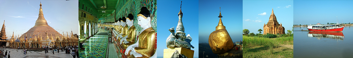
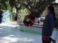
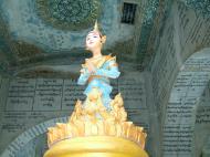
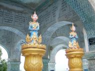
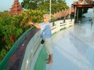
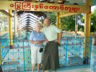
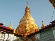
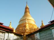
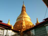
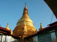
Su Taung Pyae ဆုတောင်းပြည့်ဘုရား
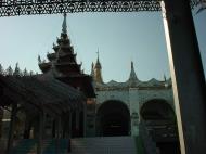
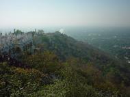
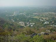
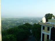
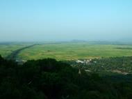
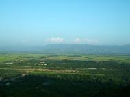
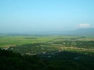
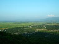
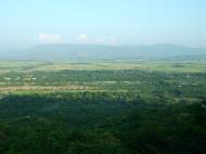
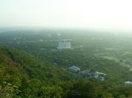
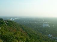
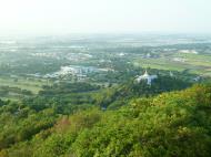
(literally wish-fulfilling)Mandalay Hill is a 240 metre (790 ft) hill that is located to the northeast of the city centre of Mandalay in Burma. The city took its name from the hill. Mandalay Hill is known for its abundance of pagodas and monasteries, and has been a major pilgrimage site for Burmese Buddhists for nearly two centuries. At the top of the hill is the Sutaungpyei (literally wish-fulfilling) Pagoda. A panoramic view of Mandalay from the top of Mandalay Hill alone makes it worthwhile to attempt a climb up its stairways. There are four covered stairways called saungdan leading up the hill from the south, southeast, west and north, and convenient seats of masonry work line these stairways all the way up. A one-way motor road today saves time and also makes it accessible for those who are unable to climb up the stairs, leading to an escalator and a lift to the pagoda at the summit.
Climbing Mandalay Hill
Two giant Chinthes guard the southern approach to Mandalay Hill.For those who are fit to make the climb, it is considered a rewarding experience and a meritorious deed at the same time. Two gigantic chinthes or leogryphs (stylised lion figures) stand guard at the southern and main approach at the foot of the hill, popularly known as the Chinthe hnakaung atet (two chinthes ascent). It is a gentle climb and there are many stops along the way, most importantly the hermit U Khanti's dazaung or hall where the Peshawar Relics ( three fragments of bone of the Gautama Buddha) were kept from 1923 until after the Second World War when they were moved to a building at the foot of the hill and no longer on display. Leaving U Khanti's dazaung is by way of a tunnel lined by Hnakyeik shissu or the 28 Buddhas of the past and present worlds, or alternatively up a steep flight of steps next to the tunnel. Climbers will see plenty of stalls selling flowers, paper streamers, miniature pennants and umbrellas for the Buddha, and food and refreshment for visitors and pilgrims. All the dazaungs have frieze paintings, most of them from the late Konbaung dynasty period; there is one depicting 'Awizi ngayè (Avici Hell) in gory detail.
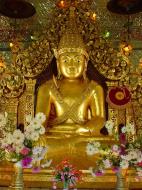
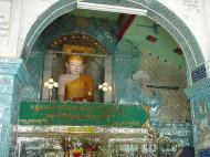
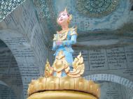
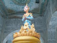
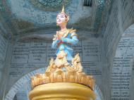
Farther up near the summit, a gigantic standing image of the Buddha called the Shweyattaw (literally standing) or Byadeippay (prophesying) Buddha with his right hand pointing towards the city. Legend has it that the Buddha once visited the place and prophesied that in the year 2400 of the Buddhist Era a great city would be built at the foot of the hill where his teachings would flourish. One curiosity that belongs to the myth surrounding the ancient kingdom of Bagan is the so-called 'Kyanzittha's spear mark' near the top of the hill. He was supposed to have executed a miraculous pole vault using his spear across the Irrawaddy!
The last stop before the Sutaungpyei pagoda completes the legend of Mandalay. Here on the south terrace of a small stupa is the image of the ogress Sanda Muhki who, for want of something to offer the Buddha, made an offering of her own breasts! And for this extreme act of merit the Buddha made the prophesy that Sanda Muhki would be reborn as a great king who would built a city at the foot of the hill and become a great supporter of Buddhism in the year 2400 of the Buddhist Era (1857 AD), the year King Mindon laid the foundations of Mandalay. On each of the four corners of the terrace can be seen a king of the ogres with his army of miniature ogre images behind him paying obeisance to the Buddha. There are also images of various creatures, one at each level before a Buddha image, such as a rabbit, a cockerel or a lizard, representations of the Buddha's innumerable reincarnations during his cycle of Samsara (birth, suffering, death and rebirth).
At the summit
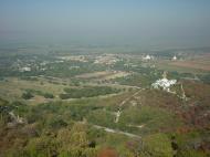
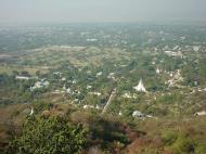
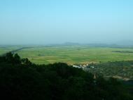
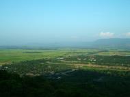
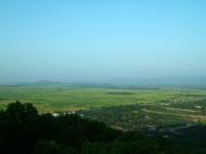
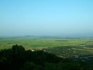
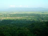
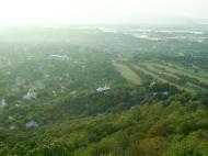
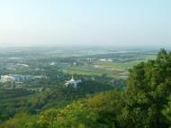
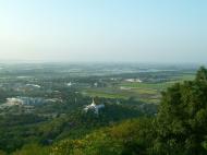
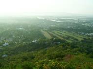
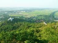
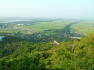
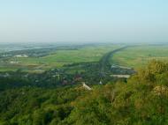
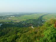
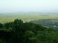
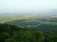
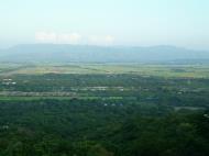
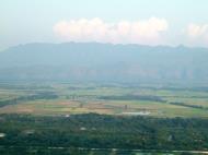
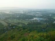
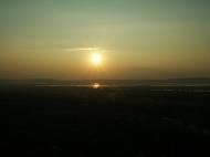
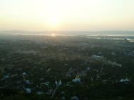
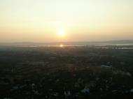
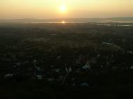
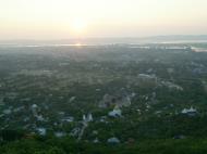
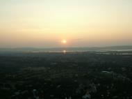
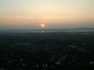
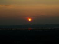
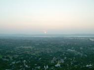
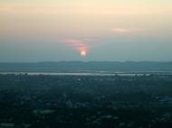
Once on the terrace of the Sutaungpyei Pagoda, a panoramic view of the Mandalay plain stretches far to the horizon, with the old city walls and moat, the Thudhamma Zayats (rest houses), various stupas around such as the Kuthodaw Pagoda and its 729 satellite stupas each housing a page inscribed in stone the world's largest book (the entire Pali Buddhist Canon), Kyautawgyi and Sandamuni Pagodas, the Irrawaddy to the west and the Minwun Hills on its opposite bank, the road to Madaya and Mogok to the north, and the Shan Yoma range of mountains to the east. There is yet a final stop down the northern slope immediately after the Sutaungpyei Pagoda called the Mwegyi hnakaung (Two Great Snakes) Pagoda. It has the images of two great cobras that were believed to frequent the hill to pay their obeisance to the Buddha and above these images seated are those of two Nats that they became when they died. Pilgrims stuff bank notes in the cobras' mouths and pray. The Champac, with its fragrant white blossoms on branches like candelabra, grows wild on the hill, along with the crimson red flowers over the feathery foliage of the Flame tree. Sunset over the river and the western hills as seen from Mandalay Hill can be a wonderful experience, and crowds of tourists may be encountered in the evenings enjoying it.World War II
In March 1945 the British Fourteenth Army's Indian 19th Infantry Division under the command of Major-General Thomas Wynford 'Pete' Rees, dubbed the 'Pocket Napoleon' by his men on account of his size and successful military career, was closing in on the Japanese in Mandalay where resistance was based mainly at Mandalay Hill with its pagodas and temples honeycombed for machine-guns , well supplied and heavily garrisoned. Fort Dufferin or the walled city with the royal palace was another pocket of resistance by the remaining Japanese troops. A Gurkha battalion stormed up the hill engaging in fierce hand-to-hand fighting all day and night on the 9th of March, and they were joined the next day by two companies of a British battalion.The Japanese stood firm and the last defenders had to be blown out from the cellars by rolling down petrol drums and igniting them with tracer bullets. It was not until the 11th of March that the hill fell into British hands. Aerial bombardment was resorted to when shelling from the hill failed to breach the city wall and destroy the enemy, and Mandalay Palace, a national heritage of great importance, burnt down during the siege. Whether it was the shelling and bombing or the enemy that destroyed the splendid teak palace was never determined with any certainty.
マンダレーヒル Mandalay Hill
旧王宮の北東にあるマンダレーヒルは丘全体が寺院となったマンダレー最大の聖地で、南参道入口の両側を2頭の大きな真っ白のライオンが守っています。頂上 は広いテラスになっており、中央の塔には仏像が安置されています。テラスからはマンダレー市街や旧王宮、エーヤワディー川、ミングォンなどが見られます。 また、マンダレーヒルから美しい夕日をご覧いただけます。マンダレーヒルに数ある仏像のなかでも名高いのは「予言を与え給う仏陀」像。仏像は高さ約8メー トル、全体が金箔でチーク材を彫ったものがあり、このような巨木を丘の上まで運び上げ、仏像に彫り上げたミャンマー仏教徒達の熱心な信仰心が窺えます。旧 王宮の方角を指している仏像の前には、いつも大勢の人々が参拝しています。Mandalay Division
Mandalay Division is an administrative division of Myanmar. It is located in the center of the country, bordering Sagaing Division and Magway Division to the west, Shan State to the east, and Bago Division and Kayin State to the south. The regional capital is Mandalay. In the south of the division lies the national capital of Naypyidaw. The division consists of seven districts, which are subdivided into 30 townships and 2,320 wards and village-tracts.
Mandalay Division is important in Burma's economy, accounting for 15% of the national economy.
History
The Tibeto-Burman speaking Pyu were the first historical people to dominate the dry zone in central Myanmar that includes Mandalay Division as early as the 1st century AD. By the early 9th century, the Pyu were decimated in a series of wars with the Nanzhao kingdom from Yunnan. The Burmans, who had been migrating into the region from Yunnan since 7th century, founded a city of their own, Pagan, in 849. The Pagan dynasty slowly came to dominate the central zone over the next two centuries, and by the late 11th century, all of present day Myanmar. The Burmese language and script came to prominence with royal patronage of Pagan kings.After the fall of Pagan to the Mongols in 1287, parts of central Myanmar came to be controlled by a series of rulers: the Mongols (1287-c.1303), Myinsaing (1298-1312), Pinya (1312-1364), and Sagaing (1315-1364). In 1364, Ava kingdom led by Burmanized Shan kings reunified all of central Myanmar. Central Myanmar was under Ava's control until 1527, and under the Shans of Monhyin (1527-1555). Burmese literature and culture came into its own during this era.
Central Myanmar was part of the Taungoo kingdom from 1555 to 1752. Parts of the region fell briefly to the Mons of Pegu (Bago) (1752-1753). Konbaung Dynasty ruled the region until December 1885 when it lost all of Upper Myanmar in the Third Anglo-Burmese War. The British rule in Upper Myanmar lasted until May 1942 when the Japanese forces captured Mandalay during World War II. The British returned after the war and granted independence the country in January 1948. Upon independence, Mandalay Division ceded Myitkyina and Bhamo districts to the newly formed Kachin State.
Demographics
The majority of the population in Mandalay Division are Bamar (Burmans). In the Mandalay metropolitan area, however, a large community of Chinese, most of whom are recent immigrants from Yunnan, now nearly rival the Bamar population. A large community of Indians also reside in Mandalay. A dwindling community of Anglo-Burmese still exists in both Pyinoolwin and Mandalay. A number of Shan people live along the eastern border of the division.Burmese is the primary language of the division. However, Mandarin Chinese is increasingly spoken in Mandalay and the northern gem mining town of Mogok.
Economy
Agriculture is the primary economical source of livelihood. Primary crops grown within Mandalay Division are rice, wheat, maise, peanut, sesame, cotton, legumes, tobacco, chilli, and vegetables. Industry, including alcoholic breweries, textile factories, sugar mills, and gem mines also exists. Tourism now forms a substantial part of Mandalay Division's economy, as it contains many historical sites including Mandalay, Amarapura, Bagan, Pyin U Lwin, Mount Popa, and Ava. Hardwoods such as teak and thanaka are also harvested.Education
Educational opportunities in Myanmar are extremely limited outside the main cities of Yangon and Mandalay. According to official statistics, whose accuracy is highly doubtful at best, over 1 million students were enrolled in the division's 4467 primary and secondary schools in 2005. Although the statistics claim a 15% primary school dropout rate, the real rate is certainly far higher. Indeed, of the nearly 4500 schools, almost 4000 were primary or post-primary schools, while only 234 were middle schools and 227 were high schools.Still the division has some of the best institutions of higher education in Myanmar. As medical, engineering and computer studies are the most sought after in Myanmar, the University of Medicine, Mandalay, the University of Dental Medicine, Mandalay, Mandalay Technological University, and the University of Computer Studies, Mandalay are among the most selective universities in Myanmar. Other highly selective schools are Myanmar Aerospace Engineering University and military academies in Pyinoolwin: Defence Services Academy and Defence Services Technological Academy.
Health care
The general state of health care in Myanmar is poor. The military government spends anywhere from 0.5% to 3% of the country's GDP on health care, consistently ranking among the lowest in the world. Although health care is nominally free, in reality, patients have to pay for medicine and treatment, even in public clinics and hospitals. Public hospitals lack many of the basic facilities and equipment.In 2005, Mandalay Division's public health care system had slightly over 1000 doctors and about 2000 nurses working in 44 hospitals and 44 health clinics. Over 30 of the so-called hospitals had less than 100 beds. Almost all of large public hospitals and private hospitals as well as doctors are in Mandalay. (These dismal numbers are believed to have improved by the advent of Naypyidaw as the nation's capital in 2006 although the level of improvement remains unreported.) The well-to-do bypass the public health system and go to private clinics in Mandalay or Yangon in order to 'get quick medical attention and high-quality service'. The wealthy routinely go abroad (usually Bangkok or Singapore) for treatment.
Web References:
https://en.wikipedia.org/wiki/Bagan
https://en.wikipedia.org/wiki/Mandalay_Division
Su Taung Pyae ဆုတောင်းပြည့်ဘုရား, Myanmar (Burma) Map
 Editor for Asisbiz: Matthew Laird Acred
If you love our website Please donate so we can make this site even better !!
Please donate so we can make this site even better !!