|
 |
 |
 |
 |
 |
 |
 |
 |
 |
 |
 |
 |
 |
 |
 |
 |
 |
 |
 |
 |
 |
 |
 |
 |
 |
 |
 |
 |
 |
 |
 |
 |
 |
 |
 |
 |
 |
 |
 |
 |
 |
 |
 |
 |
 |
 |
 |
 |
 |
 |
 |
 |
 |
 |
 |
 |
 |
 |
 |
 |
 |
 |
 |
 |
 |
 |
 |
 |
 |
 |
 |
 |
 |
 |
 |
 |
 |
 |
 |
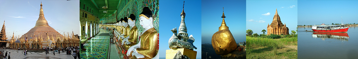
Mount Popa
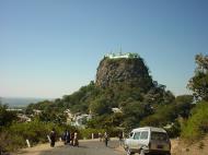
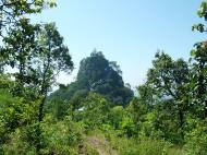
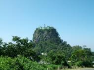
Popa is about 50 kilometers from Bagan. Popa region is situated in Kyaukpadaung Township, Mandalay Division, in the central part of the country. Mount Popa is also known as an extinct volcano and the adobe of the 37 spirits. The Mount Popa is a distinctive mountain in this region. It is an old volcano forming the northern offshoot of the Bago Yoma mountain range, occupying the lower central region. The mountain is 4900 feet high above the sea-level. From the Ayeyarwaddy River, it is about 65 kilometers away.
Along the southwest spur of the mountain a turret of rocky prominence about one acre wide at the summit rises to a height od 3000 feet above the sea-level. It is known as the Taunkalat or the 'stemmed salver hill'. This is where the home of the spirits is. There is a legend about this mountain and the spirits which goes back to the time of the King Anawrahta reign.
King Anawrahta was the founder of the Bagan Dynasty. During his reign, there was a fast-runner known as 'Byatta' who came all the way from Bagan to fetch fresh flowers from Mount Popa and offer to the king. One day he met an ogress known as 'Mel Wunna', who ate only flowers, and they had two sons.
The sons were known as Shwe Phyin Gyi and Shwe Phyin Lay or the Shwe Phyin Brothers. And later on, this place became to be the adobe of the spirits.
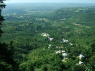
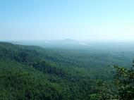
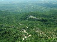
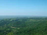
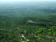
Although, Mount Popa is located in the dry zone, due to its height it is capable of collecting condensate and the mountain supports a profusion of trees and vegetation. But it was like an oasis in the middle of the dry plain. There used to be about 200 springs in the area and it is now preserved with the Greening Project according to the schedules.
Web references: http://www.ancientbagan.com/mt-popa.htm
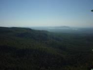
Mount Popa is a volcano 1518 metres (4981 feet) above sea level, believed to be extinct, and located in central Burma (Myanmar) about 50 km (30 miles) east of Bagan. It can be seen from the River Ayeyarwady (Irrawaddy) as far away as 60 km (40 miles) in clear weather.
Features
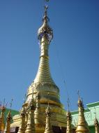
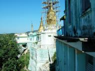
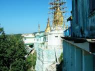
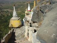
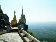
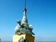
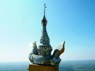
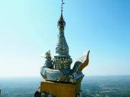
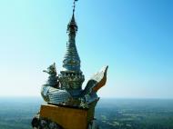
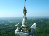
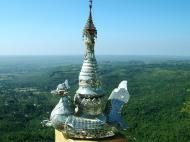
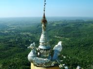
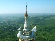
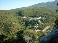
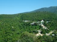
Southwest of Mount Popa is Taung Kalat (pedestal hill), a 737 metre (2,417 ft) sheer precipice of volcanic plug. A Buddhist monastery is located at the summit of Taung Kalat. At one time, the Buddhist hermit U Khandi maintained the stairway of 777 steps to the summit of Taung Kalat. It is also sometimes called Mount Popa, but to avoid confusion the big volcano with its huge crater blown open on one side is generally called Taung Ma-gyi (mother hill). The volcanic crater its self is a mile in diameter.
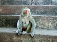
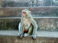
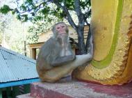
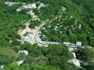
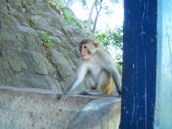
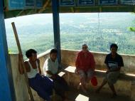
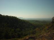
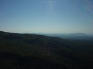
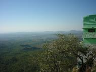
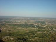
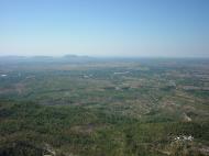
From the top of Taung Kalat, one can enjoy a panoramic view in all four directions. One can see the ancient city of Bagan; behind it to the north, the massive solitary conical peak of Taung Ma-gyi rises like Mount Fuji in Japan. There is a big caldera, 610 metres (2,000 ft) wide and 914 metres (3,000 ft) in depth so that from different directions the mountain takes different forms with more than one peak. The surrounding areas are arid, but the Mt Popa area has over 200 springs and streams. It is therefore likened to an oasis in the desert-like dry central zone of Burma. This means the surrounding landscape is characterized by prickly bushes and stunted trees as opposed to the lush forests and rivers Burma is famous for. Plenty of trees, flowering plants and herbs grow due to its fertile soil from the volcanic ash. The name Popa is indeed believed to come from the Pali Sanskrit word 'popa' meaning flower. Prominent among the fauna are Macaque monkeys that have become a tourist attraction on Taung Kalat.
History and legend
Many legends are associated with this mountain including its dubious creation from a great earthquake and the mountain erupted out of the ground in 442 B.C.
Mount Popa is considered the abode of Burma's most powerful Nats and as such is the most important nat worship center. It has therefore been called Burma's Mount Olympus. Brother and sister Mahagiri (Great Mountain) nats, from the kingdom of Tagaung at the upper reaches of the Irrawaddy, sought refuge from King Thinligyaung of Bagan (344-387). Their wish was granted and they were enshrined on Mt Popa. Popa Medaw (Royal Mother of Popa), who according to legend was a flower-eating ogress called Me Wunna, lived at Popa. She fell in love with Byatta, whose royal duty was to gather flowers from Popa for King Anawrahta of Bagan (1044-1077). Byatta was executed for disobeying the king who disapproved of the liaison, and their sons were later taken away to the palace. Me Wunna died of a broken heart and, like Byatta, became a nat. Their sons also became heroes in the king's service but were later executed for neglecting their duty during the construction of a pagoda at Taungbyone near Mandalay. They too became powerful nats but they remained in Taungbyone where a major festival is held annually in the month of Wagaung (August). Although all 37 Nats of the official pantheon are represented at the shrine on Mt Popa, in fact only four of them - the Mahagiri nats, Byatta and Me Wunna - have their abode here.
Popular destination
Me Wunna with her sons Min Gyi and Min Lay at Mt Popa
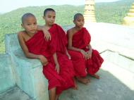
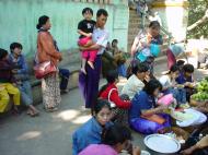
Many Burmese pilgrims visit Mt Popa every year, especially at festival season on the full moon of Nayon (May/June) and the full moon of Nadaw (November/December). Local people from the foot of Mt Popa, at Kyaukpadaung (10-miles), go mass-hiking to the peak during December and also in April when the Myanmar new year called Thingyan festival is celebrated. Before King Anawrahta's time, hundreds of animals were sacrificed to the nats during festivals.
Burmese superstition says that on Mt Popa, one should not wear red or black or bring meat, especially pork, as it could offend the resident nats, although Byatta and his brother Byatwi were the only Muslims who had shipwrecked and landed in Burma.
Development
It is now a designated nature reserve and national park. Nearby lies Kyetmauk Taung Reservoir that provides sufficient water for gardens and orchards producing jackfruit, banana, mango and papaya as well as flowering trees such as saga (Champac) and gant gaw (Mesua ferrea Linn). A pozzolan mill to supply material for the construction of Yeywa Dam on Myitnge River near Mandalay is in operation.
However, there are downsides to the development of the Mount Popa area. Tourism can be both a positive and negative factor for the economic and social development of the area. Since the mountain is so unique from the surrounding lands it attracts much attention from the Burmese citizens. There are many Burmese myths about the mountain, especially the one that said victory for any man who collected their army on the slopes of the mountain was guaranteed. The belief that victory can be guaranteed by visiting Mount Popa is interesting because it shows the cultural identification of life and prosperity with the mountain. The still current popularity of Mount Popa exemplifies the fact that Burmese people still rely heavily on ancient traditions in daily life. It is these ancient traditions that characterize the culture of the surrounding area and beyond. People travel great distances to assure their good luck into the coming years to Mount Popa, host to an immense annual festival which actually takes place in the temple atop the mountain.
The festival involves a transgender medium being possessed by a nat spirit which give him the ability to communicate between the nats and the people. It is these types of festivals, the type that are unique to the region but also incredibly important to the participants, that attracts tourists to Burma. The tourist business is booming in Burma, however this new source of income is not propelling the Burmese population to prosperity. The Burmese tourist trade is actually causing many problems in the country and assisting the military government oppress its people. One major problem of the tourist trade is the religious importance of Mount Popa is being exploited. In Burma the government is more focused on the expansion of tourism as opposed to the defense of cultural practices. There are no security measures in place to keep religious sites, like Mount Popa, away from the detrimental effects of tourism. It has even been asserted that the government turned to promoting tourism in order to fund the oppression of ethnic minorities. It is with the extra revenue that tourism brings that the military government is still able to fund its relocation and other projects.
Sites like Mount Popa are located on many websites describing the ‘must see’ sights of Burma. The military junta is utilizing the novelty of the ceremonies being performed on Mount Popa to entice tourists to visit the religious site without protecting the sites and the local people from the effects of such an increase in tourism. The government has actually been accused of using forced labor in its efforts to promote tourism. However, while there are many negatives to the tourist trade, there are also many people living near Mount Popa who rely on both the religious pilgrims and the tourists to fulfill their economic wants. The town of Kyaukpadaung at the foot of Mount Popa builds its market place around the selling of flowers for worshipers, peanuts for the monkeys that live in the Mount Popa forests and souvenirs for the tourists. It is this double-edged sword that makes tourism so hard to stop in Burma. While the government funds its operations with such tourism it has also quickly become the livelihood of many of the people living near these tourist sites.
Web references: https://en.wikipedia.org/wiki/Mount_Popa
Mandalay Division
Mandalay Division is an administrative division of Myanmar. It is located in the center of the country, bordering Sagaing Division and Magway Division to the west, Shan State to the east, and Bago Division and Kayin State to the south. The regional capital is Mandalay. In the south of the division lies the national capital of Naypyidaw. The division consists of seven districts, which are subdivided into 30 townships and 2,320 wards and village-tracts.
Mandalay Division is important in Burma's economy, accounting for 15% of the national economy.
History
The Tibeto-Burman speaking Pyu were the first historical people to dominate the dry zone in central Myanmar that includes Mandalay Division as early as the 1st century AD. By the early 9th century, the Pyu were decimated in a series of wars with the Nanzhao kingdom from Yunnan. The Burmans, who had been migrating into the region from Yunnan since 7th century, founded a city of their own, Pagan, in 849. The Pagan dynasty slowly came to dominate the central zone over the next two centuries, and by the late 11th century, all of present day Myanmar. The Burmese language and script came to prominence with royal patronage of Pagan kings.
After the fall of Pagan to the Mongols in 1287, parts of central Myanmar came to be controlled by a series of rulers: the Mongols (1287-c.1303), Myinsaing (1298-1312), Pinya (1312-1364), and Sagaing (1315-1364). In 1364, Ava kingdom led by Burmanized Shan kings reunified all of central Myanmar. Central Myanmar was under Ava's control until 1527, and under the Shans of Monhyin (1527-1555). Burmese literature and culture came into its own during this era.
Central Myanmar was part of the Taungoo kingdom from 1555 to 1752. Parts of the region fell briefly to the Mons of Pegu (Bago) (1752-1753). Konbaung Dynasty ruled the region until December 1885 when it lost all of Upper Myanmar in the Third Anglo-Burmese War. The British rule in Upper Myanmar lasted until May 1942 when the Japanese forces captured Mandalay during World War II. The British returned after the war and granted independence the country in January 1948. Upon independence, Mandalay Division ceded Myitkyina and Bhamo districts to the newly formed Kachin State.
Demographics
The majority of the population in Mandalay Division are Bamar (Burmans). In the Mandalay metropolitan area, however, a large community of Chinese, most of whom are recent immigrants from Yunnan, now nearly rival the Bamar population. A large community of Indians also reside in Mandalay. A dwindling community of Anglo-Burmese still exists in both Pyinoolwin and Mandalay. A number of Shan people live along the eastern border of the division.
Burmese is the primary language of the division. However, Mandarin Chinese is increasingly spoken in Mandalay and the northern gem mining town of Mogok.
Economy
Agriculture is the primary economical source of livelihood. Primary crops grown within Mandalay Division are rice, wheat, maise, peanut, sesame, cotton, legumes, tobacco, chilli, and vegetables. Industry, including alcoholic breweries, textile factories, sugar mills, and gem mines also exists. Tourism now forms a substantial part of Mandalay Division's economy, as it contains many historical sites including Mandalay, Amarapura, Bagan, Pyin U Lwin, Mount Popa, and Ava. Hardwoods such as teak and thanaka are also harvested.
Education
Educational opportunities in Myanmar are extremely limited outside the main cities of Yangon and Mandalay. According to official statistics, whose accuracy is highly doubtful at best, over 1 million students were enrolled in the division's 4467 primary and secondary schools in 2005. Although the statistics claim a 15% primary school dropout rate, the real rate is certainly far higher. Indeed, of the nearly 4500 schools, almost 4000 were primary or post-primary schools, while only 234 were middle schools and 227 were high schools.
Still the division has some of the best institutions of higher education in Myanmar. As medical, engineering and computer studies are the most sought after in Myanmar, the University of Medicine, Mandalay, the University of Dental Medicine, Mandalay, Mandalay Technological University, and the University of Computer Studies, Mandalay are among the most selective universities in Myanmar. Other highly selective schools are Myanmar Aerospace Engineering University and military academies in Pyinoolwin: Defence Services Academy and Defence Services Technological Academy.
Health care
The general state of health care in Myanmar is poor. The military government spends anywhere from 0.5% to 3% of the country's GDP on health care, consistently ranking among the lowest in the world. Although health care is nominally free, in reality, patients have to pay for medicine and treatment, even in public clinics and hospitals. Public hospitals lack many of the basic facilities and equipment.
In 2005, Mandalay Division's public health care system had slightly over 1000 doctors and about 2000 nurses working in 44 hospitals and 44 health clinics. Over 30 of the so-called hospitals had less than 100 beds. Almost all of large public hospitals and private hospitals as well as doctors are in Mandalay. (These dismal numbers are believed to have improved by the advent of Naypyidaw as the nation's capital in 2006 although the level of improvement remains unreported.) The well-to-do bypass the public health system and go to private clinics in Mandalay or Yangon in order to 'get quick medical attention and high-quality service'. The wealthy routinely go abroad (usually Bangkok or Singapore) for treatment.
Web References:
https://en.wikipedia.org/wiki/Bagan
https://en.wikipedia.org/wiki/Mandalay_Division
Mount Popa, Myanmar (Burma) Map
 Editor for Asisbiz: Matthew Laird Acred
If you love our website Please donate so we can make this site even better !!
Please donate so we can make this site even better !!