 |
 |
 |
 |
 |
 |
 |
 |
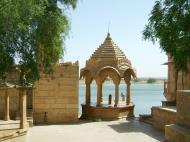
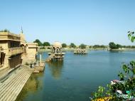
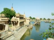
Gadi Sagar Lake
Gadi Sagar Lake is one of the most important tourist attractions in Jaisalmer, Rajasthan, North India. Its charm lies in the fact that it was the only source of water for the Jaisalmer city in the olden days.
A manmade reservoir, the Gadi Sagar Lake in Jaisalmer, Rajasthan was constructed by Raja Rawal Jaisal, the first ruler of Jaisalmer. In the later years Maharaja Garisisar Singh rebuilt and revamped the lake.
Artistically carved Chattris, Temples, Shrines and Ghats surround the banks of Gadi Sagar Lake Jaisalmer. Located towards the south of Jaisalmer city the entrance to the Gadi Sagar Lake or Garsisar Tank is through a magnificent and artistically carved yellow sandstone archway that is known as the Tilon-Ki-Pol.
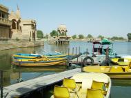
See rare migratory birds that stop for a drink at the lustrous Gadi Sagar Lake that reflects the mellow yellow of the picturesque sandstone banks; enjoy a boat ride on the lake or just sit on any of the Ghats and see the yellow sandstone banks change hues of ochre with the setting sun, a delightful panorama that you would not miss for the world. The serene Gadi Sagar Lake springs to life during the annual Gangaur celebrations. The view of the Jaisalmer Fort from the Gadi Sagar Lake is breathtaking.
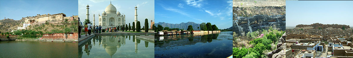
Jaisalmer जैसलमेर, ‘The Golden City’, Rajasthan
Jaisalmer (Hindi: जैसलमेर), nicknamed 'The Golden City', is a town in the Indian state of Rajasthan. The town stands on a ridge of yellowish sandstone, crowned by a fort, which contains the palace and several ornate Jain temples. Many of the houses and temples are finely sculptured. It lies in the heart of the Thar Desert and has a population of about 78,000. It is the administrative headquarters of Jaisalmer District.
Origin of name
Jaisalmer is named after its founder Rawal Jaisal. 'Jaisalmer' means 'the Hill Fort of Jaisal'. Jaisalmer is also called as the Golden city of India because the yellow sand gives a yellowish-golden touch to the city & its surrounding area.
History
The majority of any inhabitants of Jaisalmer are Bhatti Rajputs, who take their name from an ancestor named Bhatti, renowned as a warrior when the tribe were located in the Punjab. Shortly after this the clan was driven southwards, and found a refuge in the Indian desert, which was henceforth its home. Deoraj, a famous prince of the Bhati family, is esteemed the real founder of the Jaisalmer dynasty, and with him the title of rawal commenced. In 1156 Rawal Jaisal, the sixth in succession from Deoraj, founded the fort and city of Jaisalmer, and made it his capital as he moved from his former capital at Lodhruva (which is situated about 15 km to the south-east of Jaisalmer). In 1293, the Bhattis so enraged the emperor Ala-ud-din Khilji that his army captured and sacked the fort and city of Jaisalmer, so that for some time it was quite deserted. Some Bhatti's migrated to Talwandi, now Nankana Sahib in Distt. Nankana Sahib (Punjab, Pakistan) and others settled in Larkana (in Sind, Pakistan)under the name of Bhutto. In Nankana Sahib, the Bhatti Clan can be traced from the lineage of Rai Bhoe and Rai Bular Bhatti. After this there is nothing to record until the time of Rawal Sahal Singh, whose reign marks an epoch in Bhatti history in that he acknowledged the supremacy of the Mughal emperor Shah Jahan. The Jaisalmer princes had now arrived at the height of their power, but from this time till the accession of Rawal Mulraj in 1762 the fortunes of the state rapidly declined, and most of its outlying provinces were lost. In 1818 Mulraj entered into political relations with the British. Maharawal Salivahan, born in 1887, succeeded to the chiefship in 1891.
The Maharajas of Jaisalmer trace their lineage back to Jaitsimha, a ruler of the Bhatti Rajput clan. The major opponents of the Bhati Rajputs were the powerful Rathor clans of Jodhpur and Bikaner. They used to fight battles for the possession of forts, waterholes or cattle. Jaisalmer was positioned strategically and was a halting point along a traditional trade route traversed by the camel caravans of Indian and Asian merchants. The route linked India to Central Asia, Egypt, Arabia, Persia, Africa and the West.
Medieval period
During the Islamic invasion of India, Jaisalmer escaped direct Muslim conquest due to its geographical situation in the desert region. The Rawals of Jaisalmer agreed to pay an annual tribute to the Delhi Sultans. The first siege of Jaisalmer occurred during the reign of Alauddin Khilji. It was provoked by Bhatis' raid on a caravan filled with treasure. According to local ballads, the Bhatis defended the fort for seven years until the enemy army forced beached the ramparts. Bhatis, facing certain defeat, proclaimed the rite of jauhar. Later, Sultan Ferozshah also sieged Jaisalmer after the rulers of Jaisalmer raided his camp at Anasagar lake near Ajmer. The siege led to another jauhar. Jaitsimha's son Duda perished in the attack. Duda's descendants ruled over Jaisalmer for about two centuries. Duda's descendant Lunakarna had a fight with Humayun when the latter passed through Jaisalmer en route to Ajmer. Mughal emperor Akbar was married to one of the Jaisalmer princesses.
Later, Jaisalmer was ruled by a noble called Sabala Simha, who won the patronage of the Mughal emperor Shah Jahan for services rendered in his Peshawar campaign.
Princely Jaisalmer
Jaisalmer was one of the last states to sign a treaty with the British. During the British Raj, Jaisalmer was the seat of a princely state of the same name, ruled by the Bhati clan of rajputs. The present descendant is Brijraj Singh. Though the city is under the governance of the Government of India, a lot of welfare work is carried out by him and his family. The Royal Family still commands a lot of respect from the people.
Traditionally, the main source of income was the levies on the caravans. However, the glory of Jaisalmer faded when Bombay emerged as a port and the sea trade replaced the traditional land routes. The partition of India in 1947 lead to closing of all the trade routes on the Indo-Pak border and rendered Jaisalmer a drought-prone desert backwater on the international border. Ironically, skirmishes between India and Pakistan gave Jaisalmer a strategic importance and made it serviceable as an army supply depot. Later, the Rajasthan Canal served to revive the surrounding desert areas. Roads and railroads were then built, knitting the hitherto remote town with the rest of Rajasthan.
Later, the Government of Rajasthan decided to promote Jaisalmer as a tourist destination.
Geography
Jaisalmer is located at 26°55′N 70°54′E / 26.92°N 70.9°E It has an average elevation of 229 metres (751 feet).
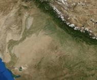
Jaisalmer is situated on the border of India and Pakistan in West Rajasthan. The area of Jaisalmer is 5.1 km². The maximum summer temperature is around 41.6 °C while the minimum is 25 °C. The maximum winter temperature is 23.6 °C while the minimum is 7.9 °C. The average rainfall is 150 mm.
Jaisalmer is almost entirely a sandy waste, forming a part of the great Indian desert. The general aspect of the area is that of an interminable sea of sandhills, of all shapes and sizes, some rising to a height of 150 ft. Those in the west are covered with log bushes, those in the east with tufts of long grass. Water is scarce, and generally brackish; the average depth of the wells is said to be about 250 ft. There are no perennial streams, and only one small river, the Kakni, which, after flowing a distance of 28 m., spreads over a large surface of flat ground, and forms a lake orjhil called the Bhuj-Jhil. The climate is dry and healthy. Throughout Jaisalmer only raincrops, such as bajra, jawar, motif, til, etc., are grown; spring crops of wheat, barley, etc., are very rare. Owing to the scant rainfall, irrigation is almost unknown.
Distances: New Delhi (864 km), Jaipur (558 km), Mumbai (1177 km), Ahmedabad (626 km).
Economy
Tourism is a major industry in Jaisalmer.
The Government of India initiated departmental exploration for oil in 1955-56 in the Jaisalmer area. Oil India Limited's discovered natural gas in 1988 in the Jaisalmer basin.
Also known for their fine leather messenger bags made from wild camels native to the area.
Musicians and dancers are also a major cultural export of Jaisalmer to the rest of the world, Manganyar musicians played the world over since decades, and Queen Harish, the dancing whirling desert drag queen, certainly the most talented dancer from Rajasthan, is touring the world extensively and features in international movies.
Bada Bagh Panorama in the afternoonTransport
Jaisalmer is the terminus of a Broad gauge branch railway of Indian Railways, junctioning with the main system at Jodhpur. The Palace on Wheels has a scheduled stop at Jaisalmer.
Demographics
As of 2001 India census, Jaisalmer had a population of 58,286. Males constitute 57% of the population and females 43%. Jaisalmer has an average literacy rate of 64%, higher than the national average of 59.5%: male literacy is 73%, and female literacy is 50%. In Jaisalmer, 16% of the population is under 6 years of age.
The main part of the population lead a wandering life, grazing their flocks and herds. Large herds of camels, horned cattle, sheep and goats are kept. The principal trade is in wool, ghee, camels, cattle and sheep. The chief imports are grain, sugar, foreign cloth, piece-goods. It suffered from famine in 1897, 1900 and other years, to such an extent that it has had to incur a heavy debt for extraordinary expenditure.
Tourism
While Jaisalmer may always have been remote, it is filled with many artistic structures and monuments of local historical importance. Jaisalmer's medieval mud fortress and walled township make it a popular tourist destination. The surrounding desolate landscape evidences a stark, austere beauty. Camel safaris through the nearby desert dunes are popular with tourists; competition for business is fierce. A few quiet days spent wandering around the town and the surrounding desert can be a wonderful way of unwinding from the chaos of larger Indian cities.
Tourist accommodation is available inside the fort itself. However, eco-conscious tourists might consider staying outside the fort to avoid putting additional pressure on the fort's archaic sewage system (three of the 99 bastions have already crumbled because of water seeping into the foundations). In the past year, there have been hotels and residents inside the fort taking initiatives to help with restoration and avoid displacement. Visitors may want to check with the local hotels inside the fort and ask what they are doing to contribute. This action could lead to tourists inside the fort supporting expedited conservation efforts through awareness and action.
Visitor attractions
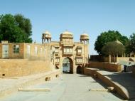
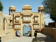
Jaisalmer Fort
Built in 1156 by the Bhati Rajput ruler Jaisal, it is situated on Trikuta Hill and had been the scene of many battles. Its massive sandstone walls are a tawny lion color during the day, turning to a magical honey-gold as the sun sets. The famous Indian film director Satyajit Ray wrote a detective novel and later turned it into a film – Sonar Kella (The Golden Fortress) which was based on this fort. This is a living fort and about a quarter of city's population still live inside the fort. The main attractions inside the fort are: Raj Mahal (Royal palace), Jain temples and the Laxminath temple.
The main havelis in Jaisalmer are:
* Patwon-ki-Haveli: Guman Chand Patwa (and later by his five sons), a wealthy merchant and banker who had over three hundred trading centres from Afghanistan to China. This ornate five-storey complex took fifty years to complete. This is the largest, the most magnificent, and the most elaborate of Jaisalmer havelis.
* Salim Singh-ki-Haveli: It was built by the scheming Prime Minister Salim Singh in 1815. It has a beautifully arched roof capped with blue cupolas and carved brackets in the form of peacocks.
* Nathmalji-ki-Haveli: Built by a Prime Minister of princely state of Jaisalmer. Its facade is a riot of ornamentation: flowers, birds, elephants, soldiers, a bicycle and even a steam engine.
* Simla Haveli': this is a 500 year old builing in jaisalmer fort* Mehra haveli: Built by Gopikishan Mehra ,Mayor of Jaisalmer city.He named haveli after his grandmother Parwati davi Parwati Sadan
Museums
* Desert Culture Centre & Museum
* Jaisalmer Folklore Museum
* Government Museum
* Mehra Haveli
* Haveli ShreenathOther
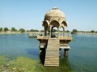
* Gadsisar Lake
Excavated in 1367 by Rawal Gadsi Singh, it is a scenic rainwater lake surrounded by small temples and shrines.
In neighbourhood
* Bhattiani Sati Rani
* Bada Bagh
* Amar Sagar
* Lodhruva
* Mool Sagar
* Kuldhara
* Desert National Park
* Sam sand dunes
* Khuri village
* Akal Wood fossil Park
* BhaniyanaDesert festival
This is held over three days in Jan/Feb every year. This is the best time to visit Jaisalmer to witness many performing arts like Kalbelia dances and folk songs and music.
Rājasthān (Devanāgarī: राजस्थान)
Rājasthān (Devanāgarī: राजस्थान), is the largest state of the Republic of India in terms of area. It encompasses most of the area of the large, inhospitable Great Indian Desert (Thar Desert), which has an edge paralleling the Sutlej-Indus river valley along its border with Pakistan. The region borders Pakistan to the west, Gujarat to the southwest, Madhya Pradesh to the southeast, Uttar Pradesh and Haryana to the northeast and Punjab to the north. Rajasthan covers an area of 132,150 sq mi or 342,269 km² (about the size of Germany).
The state capital is Jaipur. Geographical features include the Thar Desert along north-western Rajasthan and the termination of the Ghaggar River near the archaeological ruins at Kalibanga, which are the oldest in the subcontinent discovered so far.
One of the world's oldest mountain ranges, the Aravalli Range, cradles the only hill station of Rajasthan, Mount Abu, and its world-famous Dilwara Temples, a sacred pilgrimage for Jains. Eastern Rajasthan has two national tiger reserves, Ranthambore and Sariska, as well as Keoladeo National Park near Bharatpur, once famous for its bird life.
Rajasthan was formed on 30 March 1949, when all erstwhile princely states ruled by Rajputs, known as Rajputana, merged into the Dominion of India. The only difference between erstwhile Rajputana and Rajasthan is that certain portions of what had been British India, in the former province of Ajmer-Merwara, were included. Portions lying geographically outside of Rajputana such as the Sumel-Tappa area were given to Madhya Pradesh.
History
The Indus Valley Civilization, one of the world's first and oldest civilizations centred around Rajasthan. Kalibangan in Hanumangarh district, Rajasthan was a major provincial capital of the Indus Valley Civilization. Traditionally the Rajputs, Naths, Jats, Bhils, Ahirs, Gujars, Meenas and some other tribes made a great contribution in building the state of Rajasthan. All these tribes suffered great difficulties to protect their culture and the land. Millions of them were martyred for this land. ‘The Hinduan Suraj’ title to Udaipur was due to Bargujars and Bhils. Jats had been fighting since beginning. Gujars had been exterminated in Bhinmal and Ajmer areas fighting with the invaders. Bhils once ruled Kota and Bundi. Bargujars were sardars in Alwar, Jodhpur and Ajmer areas. Bargujars and Meenas were ruler of Dhundhar region, Bundi. The earlier contributions of warriors and protectors of the land — Bargujars, Jats, Bhils, Gujars and Meenas — were neglected and lost in history.
Rajasthan includes most of Rajputana, which comprises a number of Rajput kingdoms as well as Jat kingdoms and a Muslim kingdom. The Jats were rulers in Bharatpur and Dholpur. Tonk was ruled by a Muslim Nawab. Jodhpur, Bikaner, Udaipur, and Jaipur were some of the main Rajput states. Rajput families rose to prominence in the 6th century CE. The Rajputs resisted the Muslim incursions into India, although a number of Rajput kingdoms eventually became subservient to the Delhi Sultanate and the Mughal Empire during those empires' peak of expansion.
Mewar led others in resistance to Muslim rule: Rana Sanga fought the Battle of Khanua against Babur with Bargujar allies, the founder of the Mughal empire; and Maharana Pratap Singh resisted Akbar in Haldighati, the Bargujars were Rana's main allies. Other rulers like Raja Maan Singh of Amber were trusted allies of Muslims rulers. As the Mughal empire weakened, the Rajputs reasserted their independence. With the decline of the Mughal Empire in the 18th century, Rajputana came under attack from the Marathas and Pindaris, and the Maratha general Scindia captured Ajmer. The Rajput kings concluded treaties with the British in the early 19th century, accepting British sovereignty in return for local autonomy. Following the Mughal tradition as well as its strategic location Ajmer became a province of British India, while the autonomous Rajput states, the Muslim state Tonk, and the Jat states (Bharatpur and Dholpur) were organized into the Rajputana Agency.
The Marwaris (people from Marwar) and Rajasthan's formerly independent kingdoms created a rich architectural and cultural heritage, seen today in their numerous forts and palaces (Mahals and Havelis) which are enriched by features of Muslim and Jain architecture. The development of the frescos in Rajasthan is linked with the history of the Marwaris, who have also played a crucial role in the economic development of the region.
Geography
The main geographic features of Rajasthan are the Thar Desert and the Aravalli Range, which runs through the state from southwest to northeast, almost from one end to the other, for more than 850 km. Mount Abu is at the southwestern end of the range, separated from the main ranges by the West Banas River, although a series of broken ridges continues into Haryana in the direction of Delhi where it can be seen as outcrops in the form of the Raisina Hill and the ridges farther north. About three-fifths of Rajasthan lies northwest of the Aravallis, leaving two-fifths on the east and south.
The northwestern portion of Rajasthan is generally sandy and dry. Most of the region is covered by the Thar Desert, which extends into adjoining portions of Pakistan. The Aravalli Range does not intercept the moisture-giving southwest monsoon winds off the Arabian Sea,as it lies in a direction parallel to that of the coming monsoon winds, leaving the northwestern region in a rain shadow. The Thar Desert is thinly populated; the town of Bikaner is the largest city in the desert. The Northwestern thorn scrub forests lie in a band around the Thar Desert, between the desert and the Aravallis. This region receives less than 400 mm of rain in an average year. Summer temperatures can exceed 45 °C in the summer months and drop below freezing in the winter. The Godwar, Marwar, and Shekhawati regions lie in the thorn scrub forest zone, along with the city of Jodhpur. The Luni River and its tributaries are the major river system of Godwar and Marwar regions, draining the western slopes of the Aravallis and emptying southwest into the great Rann of Kutch wetland in neighboring Gujarat. This river is saline in the lower reaches and remains potable only up to Balotara in Barmer district. The Ghaggar River, which originates in Haryana, is an intermittent stream that disappears into the sands of the Thar Desert in the northern corner of the state and is seen as a remnant of the primitive Saraswati river.
The Aravalli Range and the lands to the east and southeast of the range are generally more fertile and better watered. This region is home to the Kathiarbar-Gir dry deciduous forests ecoregion, with tropical dry broadleaf forests that include teak, Acacia, and other trees. The hilly Vagad region lies in southernmost Rajasthan, on the border with Gujarat. With the exception of Mount Abu, Vagad is the wettest region in Rajasthan, and the most heavily forested. North of Vagad lies the Mewar region, home to the cities of Udaipur and Chittaurgarh. The Hadoti region lies to the southeast, on the border with Madhya Pradesh. North of Hadoti and Mewar is the Dhundhar region, home to the state capital of Jaipur. Mewat, the easternmost region of Rajasthan, borders Haryana and Uttar Pradesh. Eastern and southeastern Rajasthan is drained by the Banas and Chambal rivers, tributaries of the Ganges.
The Aravali Range runs across the state from the southwest peak Guru Shikhar (Mount Abu), which is 1,722 m in height, to Khetri in the northeast. This divides the state into 60% in the northwest of the range and 40% in the southeast. The northwest tract is sandy and unproductive with little water but improves gradually from desert land in the far west and northwest to comparatively fertile and habitable land towards the east. The area includes the Thar Desert. The south-eastern area, higher in elevation (100 to 350 m above sea level) and more fertile, has a very diversified topography. in the south lies the hilly tract of Mewar. In the southeast, a large area within the districts of Kota and Bundi forms a tableland. To the northeast of these districts is a rugged region (badlands) following the line of the Chambal River. Farther north the country levels out; the flat plains of the northeastern Bharatpur district are part of an alluvial basin.Major tribe in region Ajmer is Rawat.
Districts
Seven divisions of the districts.
Rajasthan is divided into 33 districts and seven divisions:* Ajmer Division: Ajmer, Bhilwara, Nagaur, Tonk.
* Bharatpur Division: Bharatpur, Dholpur, Karauli, Sawai Madhopur.
* Bikaner Division: Bikaner, Churu, Ganganagar, Hanumangarh.
* Jaipur Division: Jaipur, Alwar, Jhunjhunu, Sikar, Dausa.
* Jodhpur Division: Barmer, Jaisalmer, Jalore, Jodhpur District, Pali, Sirohi.
* Kota Division: Baran, Bundi, Jhalawar, Kota.
* Udaipur Division: Banswara District, Chittorgarh District, Pratapgarh District, Dungarpur District, Udaipur, Rajsamand
Government and politics
The Umaid Bhawan Palace is one of the largest royal palaces in the world. Rajasthan's royal families continue to play a major role in the state's politics.
The Kings had much power even after Independence until Indira Gandhi took away much of their power.
The Jain temple of Ranakpur.Rajasthan's politics has mainly been dominated by the two state stalwarts, namely, Bhairon Singh Shekhawat and Mohan Lal Sukhadia of the Bharatiya Janata Party and the Indian National Congress respectively. Shri Sukhadia ruled Rajasthan for 17 years and died in February 1982 while Shri Shekhawat is now in the national political horizon. The earlier politics were dominated by the Congress party. The main opposition party was the Bharatiya Jansangh, headed by Rajasthan's most popular leader Bhairon Singh Shekhawat and the Swatantra party headed by former rulers of Rajasthan. The Congress rule was untouched till the year 1962. But in the year 1967, Jansangh headed by Shekhawat and Swatantra party headed by Rajmata Gayatri Devi of Jaipur reached the majority point, but couldn't form a government. In 1972, the Congress won a landslide victory following the victory in the 1971 war. But after the declaration of emergency, Shekhawat became immensely popular, especially after he was forced to be arrested and was sent to Rohtak Jail in Haryana. As soon as the emergency was lifted, a joint opposition Janta Party won a thundering landslide victory winning 151 of the 200 seats. Shekhawat became the Chief Minister. The government was dismissed by Indira Gandhi in 1980 after she restored power in Delhi. In the 1980 elections, the Janta Party split at the centre giving the Congress a victory in Rajasthan.
Indira Gandhi was assassinated in the year 1984, and in the year 1985, a sympathy wave let the Congress sail through in the elections. But in 1989, which could be called a Shekhawat wave, the BJP-JD alliance won all 25 Lok Sabha seats and 140 of 200 seats in the assembly. Shekhawat became the Chief Minister for the second term. Though Janta Dal took back its support to the Shekhawat government, Shekhawat teared apart the JD and continued to rule as the Chief Minister thus earning the title of master manipulator. After the Babri Mosque demolition in Ayodhya, Shekhawat government was suspended by the P.M., Narsimha Rao and President's rule was enforced in Rajasthan. Election took place in the year 1993 in which his party won even after the breaking of its alliance with the Janta Dal.But the then governor Bali Ram Bhagat didn't allow Shekhawat to form the government, but after immense pressure from Shekhawat, who reached the majority point after supports from independents like Sardar Gurjant Singh,Rani Narendra Kanwar, Sujan Singh Yadav, Rohitashva Kumar Sharma, Kr. Arun Singh, Sundar Lal etc. crossed the majority line of 101 seats in the assembly. Shekhawat became the Chief Minister for the third term. This time he ran a successful third term. This was pehaps the diamond phase for Rajasthan as it led to all-round development and Rajasthan also gained identity on the globe as a rapidly developing and beautiful state.Shekhawat introduced Heritage, Desert, Rural, Wildlife tourism to Rajasthan In 1998 elections, the BJP lost heavily due to the onion price rise issue. Ashok Gehlot ran a 5 year government.But he lost the Lok Sabha elections in 1999, only 6 months after its victory in the assembly elections. Shekhawat became the Vice-President of India in the year 2002 so he had to leave Rajasthan politics and the BJP. He appointed Vasundhara Raje as his successor. She led the BJP in 2003 elections and led it to a victory. She was the Chief Minister of Rajasthan from 2003 - 2008. Narpat Singh Rajvi was the Health Minister, Ghanshyam Tiwari was the Food Minister, and Gulab Chand Kataria was the Home Minister. The BJP won the 2004 Lok Sabha elections from here as well. But the tables turned in December 2008, when the infighting within the BJP, Raje's perceived autocratic and despotic rule, and the police excesses in the Gujjar-Meena agitation combined to overcome the incumbent Raje government's development and growth planks, and the Congress emerged victorious with the support of some independent MLA's. Ashok Gehlot was sworn-in as the new Chief Minister of Rajasthan.
Economy
Rajasthan's economy is primarily agricultural and pastoral. Wheat and barley are cultivated over large areas, as are pulses, sugarcane, and oilseeds. Cotton and tobacco are cash crops. Rajasthan is among the largest producers of edible oils in India and the second largest producer of oilseeds. Rajasthan is also the biggest wool-producing state in India and the main opium producer and consumer. There are mainly two crop seasons. The water for irrigation comes from wells and tanks. The Indira Gandhi Canal irrigates northwestern Rajasthan.
The main industries are mineral based, agriculture based, and textiles. Rajasthan is the second largest producer of polyester fibre in India. The Bhilwara District produces more cloth than Bhiwandi, Maharashtra. Several prominent chemical and engineering companies are located in the town of Kota, in western Rajasthan. Rajasthan is pre-eminent in quarrying and mining in India. The state is the second largest source of cement in India. It has rich salt deposits at Sambhar, copper mines at Khetri and zinc mines at Dariba, Zawar mines at Zawarmala for zinc, rampura aghucha (opencast) near Bhilwara. Dimensional stone mining is also undertaken in Rajasthan: Jodhpur sandstone is mostly used in monuments, important buildings, residential buildings, etc. This stone is termed 'chittar patthar'.
Endowed with natural beauty and a great history, tourism is a flourishing industry in Rajasthan. The palaces of Jaipur, lakes of Udaipur, and desert forts of Jodhpur, Bikaner & Jaisalmer are among the most preferred destination of many tourists, Indian and foreign. Tourism accounts for eight percent of the state's domestic product. Many old and neglected palaces and forts have been converted into heritage hotels. Tourism has increased employment in the hospitality sector. Rajasthan is now the preferred destination for IT companies and North India's largest integrated IT park is located in Jaipur and is named as Mahindra World City Jaipur covering nearly 3,000 acres (12 km2) of land. Some of the companies operating in Rajasthan include Infosys, Genpact, Wipro, Truworth, Deusche Bank, NEI, MICO,Honda Siel Cars, Coca Cola , Gillete etc.
Demographics
Rajasthan has a mainly Rajasthani population. Hindus account for 88.8% of the population. Muslims make up 8.5%, Sikhs 1.4% and Jains 1.2% of the population. The state of Rajasthan is also populated by Sindhis, who came to Rajasthan from Sindh province (now in Pakistan) during the India-Pakistan separation in 1947.
The mother tongue of the majority of people in Rajasthan is Rajasthani. Rajasthani and Hindi are the most widely used languages in Rajasthan. After independence, Rajasthani was used as a medium of instruction, along with Hindi and English, in some schools. Some other languages used in Rajasthan are Sindhi and Punjabi.
See also: List of people from Rajasthan
Culture
Rajasthan is culturally rich and has artistic and cultural traditions which reflect the ancient Indian way of life. There is rich and varied folk culture from villages which is often depicted symbolic of the state. Highly cultivated classical music and dance with its own distinct style is part of the cultural tradition of Rajasthan. The music is uncomplicated and songs depict day-to-day relationships and chores, more often focused around fetching water from wells or ponds.
The Ghoomar dance from Udaipur and Kalbeliya dance of Jaisalmer have gained international recognition. Folk music is a vital part of Rajasthani culture. Kathputali, Bhopa, Chang, Teratali, Ghindar, Kachchhighori, Tejaji etc. are the examples of the traditional Rajasthani culture. Folk songs are commonly ballads which relate heroic deeds and love stories; and religious or devotional songs known as bhajans and banis (often accompanied by musical instruments like dholak, sitar, sarangi etc.) are also sung.
A decorate Indian elephant during a fair in Jaipur, IndiaRajasthan is known for its traditional, colorful art. The block prints, tie and dye prints, Bagaru prints, Sanganer prints, Zari embroidery are major export products from Rajasthan. Handicraft items like wooden furniture and handicrafts, carpets, blue pottery are some of the things commonly found here. Rajasthan is a shoppers' paradise, with beautiful goods found at low prices. Reflecting the colorful Rajasthani culture, Rajasthani clothes have a lot of mirror-work and embroidery. A Rajasthani traditional dress for females comprises an ankle length skirt and a short top, also known as a lehenga or a chaniya choli. A piece of cloth is used to cover the head, both for protection from heat and maintenance of modesty. Rajasthani dresses are usually designed in bright colours like blue, yellow and orange.
Rajasthan is famous for the majestic forts, intricately carved temples and decorated havelis, which were built by Bargujar kings in previous ages, they were the soul of pre-muslim era Rajasthan. Jantar Mantar, Dilwara Temples, Chittorgarh Fort, Lake Palace Hotel, City Palaces, Jaisalmer Havelis are part of the true architectural heritage of India. Jaipur, the Pink City, is noted for the ancient houses made of a type of sand stone dominated by a pink hue. At Ajmer, the white marble Bara-dari on the Anasagar lake is exquisite. Jain Temples dot Rajasthan from north to south and east to west. Dilwara Temples of Mount Abu, Ranakpur Temple dedicated to Lord Adinath near Udaipur, Jain temples in the fort complexes of Chittor, Jaisalmer and Kumbhalgarh, Lodarva Jain temples, Bhandasar Temple of Bikaner are some of the best examples.
Rajasthan is often called a shopper's paradise. Rajasthan is famous for textiles, semi-precious stones and handicrafts. The attractive designs of jewellery and clothes are eye-catching and invite shoppers. Rajasthani furniture has intricate carvings and bright colours. Rajasthani handicrafts are in demand due to the intricate work on them. Above all, Rajasthan's shopping appeals to both tourists and people from other parts of India due to its cheap prices for quality goods.
The main religious festivals are Deepawali, Holi, Gangaur, Teej, Gogaji, Makar Sankranti and Janmashtami, as the main religion is Hinduism. Rajasthan's desert festival is celebrated with great zest and zeal. This festival is held once a year during winters. Dressed in brilliantly hued costumes, the people of the desert dance and sing haunting ballads of valor, romance and tragedy. There are fairs with snake charmers, puppeteers, acrobats and folk performers. Camels, of course, play a stellar role in this festival.
Flora and fauna
Though a large percentage of the total area is desert, and even though there is little forest cover, Rajasthan has a rich and varied flora and fauna. The natural vegetation is classed as Northern Desert Thorn Forest (Champion 1936). These occur in small clumps scattered in a more or less open forms. Density and size of patches increase from west to east following the increase in rainfall.
Some wildlife species, which are fast vanishing in other parts of India, are found in the desert in large numbers such as the Great Indian Bustard (Ardeotis nigriceps), the Blackbuck (Antilope cervicapra), the Indian Gazelle (Gazella bennettii) and the Indian Wild Ass.
The Desert National Park, Jaisalmer, spread over an area of 3162 km², is an excellent example of the ecosystem of the Thar Desert, and its diverse fauna. Great Indian Bustard, Blackbuck, chinkara, desert fox, Bengal fox, wolf, desert cat etc. can be easily seen here. Seashells and massive fossilized tree trunks in this park record the geological history of the desert. The region is a haven for migratory and resident birds of the desert. One can see many eagles, harriers, falcons, buzzards, kestrel and vultures. Short-toed Eagles (Circaetus gallicus), Tawny Eagles (Aquila rapax), Spotted Eagles (Aquila clanga), Laggar Falcons (Falco jugger) and kestrels are the commonest of these.
Tal Chhapar Sanctuary is a very small sanctuary in Churu District, 210 km from Jaipur, in the Shekhawati region. This sanctuary is home to a large population of graceful Blackbuck. Desert Fox and desert cat can also be spotted along with typical avifauna such as partridge and sand grouse.
Transport
Rajasthan is is connected by many national highways. Most renowned being NH-8, which is India's first 4-8 lane highway. Rajasthan also has a good inter city surface transport system both in terms of railways and bus network. All important and tourist cities are connected by air, rail and road.
Statistics
* Population: 56.47 million (2001 Census, estimated at more than 58 million now)
* Cities and Towns: 222
* Major cities: Jaipur, Jodhpur, Udaipur, Kota, Ajmer, Bikaner, Sikar, Churu, Bharatpur, Bhilwara, Alwar, Sri Ganganagar ,Pali,Makrana, Bundi,chittorgarh, Didwana, Sujangarh, Nagaur, Sikar
* Roads: 61,520 km. (2,846 km National Highway)
* National highways crossing Rajasthan: Delhi-Ahmedabad, Agra-Bikaner, Jaipur-Bhopal and Bhatinda-Kandla
* Climate: Generally dry with monsoon during July-August
* Districts: 33
* Languages: English and Hindi commonly used, as well as indigenous Rajasthani languages
* Literacy: 61.03%
* In the Indian province of Rajasthan alone for instance, between the years 1999 and 2002, crimes against Dalits by upper caste average at about 8024 a year, with 76 killings and 1838 cases of rape.
 Editor for Asisbiz: Matthew Laird Acred
If you love our website please add a like on facebook
Please donate so we can make this site even better !!