|
 |
 |
 |
 |
 |
 |
 |
 |
 |
 |
 |
 |
 |
 |
 |
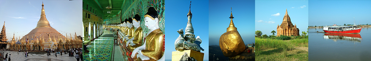
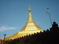
Kyaik Htee Saung Pagoda ကျိုက်ထီးဆောင်းဘုရား
Mottama, formerly known as Martaban, is a small town in the Thaton district of Mon State, in southern Burma. It is located on the right bank of the Salween River, on the opposite side of Mawlamyaing.
Mottama was the terminus of the road and the railroad from Yangon, where the Salween River empties into the Gulf of Martaban in the Andaman Sea. But, today Mawlamyaing Bridge has laid down a link from Mottama to Mawlamyaing and other city in the south Ye.
History
Mottama is believed to have been founded in A.D. 573 by the first king of Pegu. It was once the capital of the Talaing kingdom. It was a frequent trading spot in the 16th century for European explorers. A well known type of jar called 'Pegu jars' was made here. It was invaded by the British in 1824 and 1852.Geography
The Ayeyarwady River and Salween River flow into the Bay of Martaban. Coordinates: 16°32′N 97°36′ENotes
* 'Talaing' means 'Telegu' race from India according to Dr. Naing Pan Hla's Mon History.
* 'Mataban' means clay-pot in Arabic, therefore Arab traders might name the place as Mataban where they load the big clay pots to use as container of presentdays.
I can't find any information on this Pagoda. If anyone can please help send me an email. Matthew
Mon State
Mon State is an administrative division of Myanmar. It is sandwiched between Kayin State on the east, the Andaman Sea on the west, Bago Division on the north and Tanintharyi Division on the south, and has a short border with Thailand's Kanchanaburi Province at its south-eastern tip. The land area is 12,155 km². Mon State includes many small islands along its 566 km of coastline. Its capital is Mawlamyaing, formerly Moulmein.
History
Humans lived in the region that is now Myanmar as early as 11,000 years ago, but the first identifiable civilisation is that of the Mon. The Mon probably began migrating into the area southward from western China in the period from 3000 BC to 1500 BC and settled in the Chao Phraya River basin of southern Thailand around the 6th century AD.[citation needed] The Mon moved westward into the Irrawaddy Delta of southern Myanmar in the ensuing centuries. Mon tradition holds that the Suwarnabhumi mentioned in the Edicts of Ashoka and the Dîpavamsa was their first kingdom (pronounced Suvanna Bhoum), founded around the port of Thaton in about 300 BC, however, this is disputed by scholars. Oral tradition suggests that they had contact with Buddhism via seafaring as early as the 3rd century BC, though definitely by the 2nd century BC when they received an envoy of monks from Ashoka, and the Mon converted to Theravada Buddhism sometime before the sixth century, and they adopted the Indian Pali script. Much of the Mon's written records have been destroyed through wars. The Mons blended Indian and Mon cultures together in a hybrid of the two civilisations. By 825 they had firmly established themselves in southern and southeastern Myanmar and founded the cities of Bago (Pegu) and Thaton, and by the mid-9th century, they had come to dominate all of southern Myanmar.Mon kingdoms (9th-11th/13th-16th/18th centuries)
The first recorded kingdom that can undisputedly be attributed to the Mon was Dvaravati which prospered until around 1000 AD when their capital was sacked by the Khmer Empire and most of the inhabitants fled west to present-day Burma and eventually founded new kingdoms. These, too, eventually came under pressure from new ethnic groups arriving from the north.Advent of the British
Lower Burma, including what is now Mon State, was conquered by Great Britain in 1824 after the First Anglo-Burmese War. The Mon assisted the British in the war, in return for promises of their own leadership after the defeat of Burma. Hundreds of thousands of Mons who had migrated into Siam returned to their homeland when it came under British rule. However, British promises to restore the Mon Kingdom were never fulfilled. During colonial times, Moulmein had a substantial Anglo-Burmese population; an area of the city was known as 'Little England' due to the large Anglo-Burmese community, however nowadays this has dwindled to all but a handful of families as most have left for the UK or Australia.Burmese independence
In 1947, the Mon sought self-determination from the yet unformed Union of Burma; however Burmese Prime Minister U Nu refused, saying that no separate national rights for the Mon should be contemplated. The Burmese army moved into areas claimed by the Mon nationalists and imposed rule by force which resulted in a civil war. Mon separatists formed the Mon Peoples Front, which was later superseded by the New Mon State Party (NMSP) in 1962. Since 1949, the eastern hills of the state (as well as portions of Thaninthaya Division) have been under control of the NMSP, and its military arm, the Mon National Liberation Front (MNLF). In addition to fighting the central government, the MNLF has also fought the Karen people over control of lucrative border crossings into Thailand.In 1974, partially to assuage Mon separatist demands, the theoretically autonomous Mon State, was created out of portions of Thaninthayi Division and Bago Division. Resistance continued until 1995, when NMSP and SLORC agreed a cease-fire and in 1996, the Mon Unity League was founded. SLORC troops continued to operate in defiance of the agreement. The human rights situation in Mon State has not improved. International organizations have repeatedly accused the Myanmar government for massive human rights violations in Mon State, including forced labor, arbitrary detention, population transfer, property confiscation, rape, etc.
Demographics and geography
Although there are no modern figures on the population of Mon State, it is estimated that the population is around 2,466,000 or 8,466,000. The majority are Mon. However, there is a large number of ethnic Bamar, as well as members of the Kayin,and Pa-O ethnic groups and a small, dwindling Anglo-Burmese community. Many are isolated and many do not understand or speak Burmese. Have Thai Community in Kyaikkami. The majority of people are Buddhist. Bordering Bago Division in the south of Sittaung River Mouth, Kayin State in the east, Thailand and Taninthayi Division in the south and Andaman Sea and Gulf of Mottama in the West, Mon state is situated between latitudes 14°52' north and 17°32 ' north and east longitudes 96° 51 ' east and 98° 13 ' east.Climate and weather
Mon State has a tropical climate. It has a temperate weather as it is located in the low latitude zone and near the sea. The state has only slight changes in temperature. The average temperature of Mawlamyine in January is 78°F (25.6°C) and in April is 85°C (29.4°C). Annual rainfall in Mawlamyine is 190 inches (4.8 m) and in Thaton is 217 inches (5.5 m). Especially. rain is much heavy in July and August.Economy
Mon State has a cultivated area of nearly 4.5 million acres (18,000 km²), mostly under rice. The major secondary crop is rubber. Orchards and rubber plantations are found in the mountainous areas while Coastal fishing and related industries such as production of dried fish, fish sauce and agar-agar are in southern part, Ye district. Production of Betel nut is also a sustaining business of Mon state, as the Mon pheasants preserved their heredity land onwards along with the government regulations, however, there are some many parts of uncultivated crude land in the area closed to neighbour Karen state. Moreover, modern business development includes growing of cashew trees (acajoύ, in Portuguese), from which they collect the cashew nut for market elsewhere.Other industries include paper, sugar, rubber tires. Thaton has a major factory (Burmese, Ka-Sa-La) of rubber products run by Ministry of Industry. Forests cover approximately half of the area and timber production is one of the major contributors to the economy. Minerals extracted from the area include salt, antimony, and granite. Natural resources such as forest products, and onshore and offshore mineral resources, are exploited only by top Myanmar military leaders and foreign companies. At the present time one of the biggest foreign investments into Myanmar is for the exploitation of natural gas reserves in Mon State. The Yadana Gas project which connected pipelines alongside the towns of Mon state made harassed danger to the native Mon land and Mon people.
In the past during the socialist regime, the trading of Mon state was exceptional because the Mon business persons had fantastic deals with the foreign enterprises from Singapore, Malaysia and Thailand. Imports and exports of goods from and to that countries were made via seaports of Mawlamyaing, Ye and Thanbyuzayat district. Although it seemed to be unofficial trading in the past, it absolutely developed Mon State if compared to the decline economy of the current situation.
The future plans with tourism will benefit Mon state a lot as it has excellent transportation with the capital Rangoon. Transportation routes include Train, Bus, Sea line and Airlines. The newly opened Mawlamyaing Bridge gives quick access from southern Ye to North Bago and Rangoon by a day journey. Three Pagoda Pass is an alternative route which communicates Mon state with neighbour Kanchanaburi province of Thailand.
Transportation
* Ye AirportSites of interest
Kyaiktiyo Pagoda is at 3,615 ft (1,102 m) high
* Kyaiktiyo Pagoda (or) kyaik-isi-yo pagoda - A famous religious site with a steeple built on a rock covered with gold leaf, precariously balanced on the site of a cliff. Legend says that Buddha's hair was placed inside the pagoda, and its power keeps the rock from falling.
* Thaton - the former capital of an ancient Mon kingdom, much earlier than Bagan.
* Thanbyuzayat War Memorial - death railway connected with the Bridge over the River Kwai.
* Satse and Kyaik-Kami 18 miles (29 km) from Thanbyuzayati is a popular beach resort in Myanmar.
* Belu-kyun (Belu island) opposite to Mawlamyaing is rich in chemical resources as well as traditional handmake products business.Politics and administration
Mon state has a capital of Mawlamyaing, the third largest citiy in Myanmar. Administrative body is set under South Eastern Regional Command of Myanmar Army in Mawlamyine and Mawyawaddy Navy Command controls coastline security. There are many displaced army infantry battalions at many towns in Mon state and Thaton has a Light Infantry Division (44). Major districts are divided as Mawlamyaing, Thaton, Ye district, etc. At present, army infantries are densely displaced in the former neutral territory of Ye district for future plans. Ye, Myanmar becomes the major city of Southern Mon State with Sector Operation Command of Air Defense, and Military Operations Command 19 based headquarters.Organization
Mon State consists two districts. They are Mawlamyine District and Thaton District
In Mon State, there are two districts, 10 township, 1 city, 10 town, 1199 villages.
Cities with large district Towns Villages Matmalom Mudon Kawt-bane Satheim Paung Kamawak Sopbu Beeklieng Pha-auk Re Mottama Pa-nga Kyaikmaraw Kyaik-kami Jain-gyike Kyaikto Sit-taung Thein-sake Bakwai Lamine Mawkanin Chaungzon Ywar Lut
Islands Belu-kyun Kalar-goke island
Kyaik Htee Saung Pagoda ကျိုက်ထီးဆောင်းဘုရား
 Editor for Asisbiz: Matthew Laird Acred
If you love our website Please donate so we can make this site even better !!
Please donate so we can make this site even better !!