 |
 |
 |
 |
 |
 |
 |
 |
 |
 |
 |
 |
 |
 |
 |
 |
 |
 |
 |
 |
 |
Cape Town, South Africa
Flag of Cape Town old and new
Cape Town Afrikaans: Kaapstad
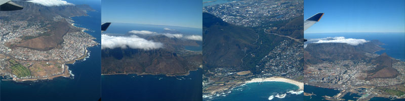
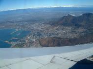
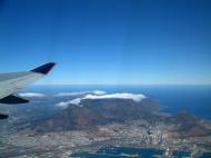
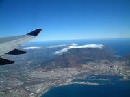
Cape Town (Afrikaans: Kaapstad; Xhosa: iKapa) is the second most populous city in South Africa, forming part of the metropolitan municipality of the City of Cape Town. It is the provincial capital of the Western Cape, as well as the legislative capital of South Africa, where the National Parliament and many government offices are located. Cape Town is famous for its harbour as well as its natural setting in the Cape floral kingdom, including such well-known landmarks as Table Mountain and Cape Point. Cape Town is Africas most popular destination for tourism.
Located on the shore of Table Bay, Cape Town was originally developed by the Dutch East India Company as a victualling (supply) station for Dutch ships sailing to Eastern Africa, India, and the Far East. Jan van Riebeeck's arrival on 6 April 1652 established the first permanent European settlement in South Africa. Cape Town quickly outgrew its original purpose as the first European outpost at the Castle of Good Hope, becoming the economic and cultural hub of the Cape Colony. Until the Witwatersrand Gold Rush and the development of Johannesburg, Cape Town was the largest city in South Africa.
As of 2007 the city had a population of 3.5 million. Cape Town's land area of 2,455 square kilometres (948 sq mi) is larger than other South African cities, resulting in a comparatively lower population density of 1,425 inhabitants per square kilometre (3,690 /sq mi).
History
There is no certainty as to when humans first occupied the area prior to the first visits of Europeans in the 15th century. The earliest known remnants in the region were found at Peers cave in Fish Hoek and date to around 12,000 years ago. Little is known of the history of the region's first residents, since there is no written history from the area before it was first mentioned by Portuguese explorer Bartolomeu Dias in 1486. Vasco da Gama recorded a sighting of the Cape of Good Hope in 1497, and the area did not have regular contact with Europeans until 1652, when the Netherlands' Jan van Riebeeck and other employees of the Dutch East India Company (Dutch: Verenigde Oost-indische Compagnie, VOC) were sent to the Cape to establish a way-station for ships travelling to the Dutch East Indies, and the Redout Duijnhoop (later replaced by the Castle of Good Hope). The city grew slowly during this period, as it was hard to find adequate labour. This labour shortage prompted the city to import slaves from Indonesia and Madagascar. Many of these became ancestors of the first Cape Coloured communities.During the French Revolutionary and Napoleonic wars, the Netherlands was repeatedly occupied by France, and Great Britain moved to take control of Dutch colonies. Britain captured Cape Town in 1795, but the Cape was returned to the Netherlands by treaty in 1803. British forces occupied the Cape again in 1806 following the battle of Bloubergstrand. In the Anglo-Dutch Treaty of 1814, Cape Town was permanently ceded to Britain. It became the capital of the newly formed Cape Colony, whose territory expanded very substantially through the 1800s.
The discovery of diamonds in Griqualand West in 1869, and the Witwatersrand Gold Rush in 1886, prompted a flood of immigrants to South Africa. Conflicts between the Boer republics in the interior and the British colonial government resulted in the Second Boer War of 1899-1901, which Britain won. In 1910, Britain established the Union of South Africa, which unified the Cape Colony with the two defeated Boer Republics and the British colony of Natal. Cape Town became the legislative capital of the Union, and later of the Republic of South Africa.
In the 1948 national elections, the National Party won on a platform of apartheid (racial segregation) under the slogan of ‘swart gevaar’. This led to the Group Areas Act, which classified all areas according to race. Formerly multi-racial suburbs of Cape Town were either purged of unlawful residents or demolished. The most infamous example of this in Cape Town was District Six. After it was declared a whites-only region in 1965, all housing there was demolished and over 60,000 residents were forcibly removed. Many of these residents were relocated to the Cape Flats and Lavendar Hill. Under apartheid, the Cape was considered a ‘Coloured labour preference area’, to the exclusion of ‘Bantus’, i.e. blacks.
Cape Town was home to many leaders of the anti-apartheid movement. On Robben Island, a former penitentiary island 10 kilometres from the city, many famous political prisoners were held for years. In one of the most famous moments marking the end of apartheid, Nelson Mandela made his first public speech in decades on 11 February 1990 from the balcony of Cape Town City Hall hours after being released. His speech heralded the beginning of a new era for the country, and the first democratic election was held four years later, on 27 April 1994. Nobel Square in the Victoria & Alfred Waterfront features statues of South Africa's four Nobel Peace Prize winners - Albert Luthuli, Desmond Tutu, F.W. de Klerk and Nelson Mandela. Since 1994, the city has struggled with problems such as HIV/AIDS, tuberculosis, a surge in violent drug-related crime and more recent xenophobic violence. At the same time, the economy has surged to unprecedented levels due to the boom in the tourism and the real estate industries.
Geography
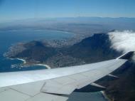
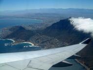
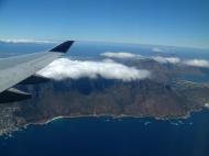
The centre of Cape Town is located at the northern end of the Cape Peninsula. Table Mountain forms a dramatic backdrop to the city bowl, with its plateau over 1,000 m (3,300 ft) high; it is surrounded by near-vertical cliffs, Devil's Peak and Lion's Head. Sometimes a thin strip of cloud forms over the mountain, and owing to its appearance, it is colloquially known as the ‘tablecloth’. The peninsula consists of a dramatic mountainous spine jutting southwards into the Atlantic Ocean, ending at Cape Point. There are over 70 peaks above 1,000 feet (300 m) (the American definition of a mountain) within Cape Town's official city limits. Many of the suburbs of Cape Town are on the large plain of the Cape Flats, which joins the peninsula to the mainland. The Cape Flats lie on what is known as a rising marine plain, consisting mostly of sandy geology which shows that at one point Table Mountain itself was an island.
ClimateThe Cape Peninsula has a Mediterranean climate with well-defined seasons. In winter, which lasts from May to September, large cold fronts come across from the Atlantic Ocean with heavy precipitation and strong north-westerly winds. The winter months are cool, with an average minimum temperature of 7 °C (45 °F). Most of the city's annual rainfall occurs in wintertime, but due to the mountainous topography of the city, rainfall amounts for specific areas can vary dramatically. The suburb of Newlands which is to the south of the city is the wettest place in South Africa. The valleys and coastal plains average 515 millimetres (20 in) of rain per annum, while mountain areas can average as much as 1,500 millimetres (60 in) per annum. Summer, which lasts from November to March, is warm and dry. The Peninsula gets frequent strong winds from the south-east, known locally as the Cape Doctor, because it blows away pollution and cleans the air. The south-easterly wind is caused by a high-pressure system which sits in the South Atlantic to the west of Cape Town, known as the South-Atlantic High. Summer temperatures are mild, with an average maximum of 26 °C (79 °F). The only times when Cape Town can be uncomfortably hot is when the Berg Wind, meaning ‘mountain wind’ blows from the Karoo interior for a couple weeks in February or early March.
Government
Cape town's local government is the City of Cape Town, which is a metropolitan municipality. Cape Town is governed by a 210-member city council, which reports to a 28-member executive council. The executive council, in turn, is presided over by a city manager and an executive mayor. The city is divided into 105 electoral wards; each ward directly elects one member of the council, whilst the other 105 councillors are elected by a party-list proportional representation system. The mayor is chosen by the city council.
In the most recent local government elections, the Democratic Alliance was the largest single party with 90 of the 210 seats on the council, ahead of the African National Congress's 81 seats, but with no party holding a majority. A subsequent by-election has increased the DA's seats to 91. The DA has now increased its majority, by introducing the Independent Democrats (South Africa) to the coalition, and so the DA-led council now has a majority of 22 seats.
Mayor Helen Zille of the Democratic Alliance resigned on 29 April 2009 as a result of her election to the Western Cape Provincial Parliament; Deputy Mayor Grant Haskin will serve as Acting Mayor until a new mayor is elected.
Demographics
According to the South African National Census of 2001, the population of Cape Town is 2,893,251 people. There are 759,767 formal households, of which 87.4% have a flush or chemical toilet, and 94.4% have refuse removed by the municipality at least once a week. 80.1% of households use electricity as the main source of energy. 16.1% of households are headed by one person.Coloured people account for 48.13% of the population, followed by Black Africans at 31%, Whites at 18.75%, and Asians at 1.43%. 46.6% of the population is under the age of 24, whilst 5% are over the age of 65. The median age in the city is 26 years old, and for every 100 females, there are 92.4 males. 19.4% of city residents are unemployed; 58.3% of the unemployed are black, 38.1% are Coloured, 3.1% are White and 0.5% are Asian.
41.4% of Cape Town residents speak Afrikaans at home, 28.7% speak Xhosa, 27.9% speak English, 0.7% speak Sotho, 0.3% speak Zulu, 0.1% speak Tswana and 0.7% of the population speaks a non-official language at home. 76.6% of residents are Christian, 10.7% have no religion, 9.7% are Muslim, 0.5% are Jewish and 0.2% are Hindu. 2.3% have other or undetermined beliefs.
4.2% of residents aged 20 and over have received no schooling; 11.8% have had some primary school; 7.1% have completed only primary school; 38.9% have had some high school education; 25.4% have finished only high school and 12.6% have an education higher than the high school level. Overall, 38.0% of residents have completed high school. The median annual income of working adults aged 20–65 is ZAR 25 774. Males have a median annual income of ZAR 27 406 versus ZAR 22 265 for females.
Economy
Cape Town is the economic centre of the Western Cape Province, South Africas 2nd main econoic centre and even Africas 3rd or 2nd main economic hub city. It serves as the regional manufacturing centre in the Western Cape. It also has the primary harbour and airport in the Western Cape. The large government presence in the city, both as the capital of the Western Cape and the seat of the National Parliament, has led to increased revenue and growth in industries that serve the government. Cape Town hosts many conferences, particularly in the new Cape Town International Convention Centre, which opened in June 2003. At the moment as South Africas 2nd biggest city, it contains more high rise buildings than South Africas biggest city metropolotein, Johannesburg. The city has recently enjoyed a booming real estate and construction market, because of the 2010 World Cup as well as many people buying summer homes in the city or relocating there permanently. The central business district is under an extensive urban renewal programme, with numerous new buildings and renovations taking place under the guidance of the Cape Town Partnership. The central business district is expecting a private-sector investment influx of ZAR30-35billion (US$5-6billion) over the next 5 years, confirmed by the Partnership.Cape Town has four major commercial nodes, with Cape Town Central Business District containing the majority of job opportunities and office space. Century City, the Bellville/TygerValley strip and Claremont commercial nodes are well established and contain many offices and corporate headquarters as well. Most companies headquartered in the city are insurance companies, retail groups, publishers, design houses, fashion designers, shipping companies, petrochemical companies, architects and advertising agencies.
Much of the produce is handled through the Port of Cape Town or Cape Town International Airport. Most major shipbuilding companies have offices and manufacturing locations in Cape Town. The Province is also a centre of energy development for the country, with the existing Koeberg nuclear power station providing energy for the Western Cape's needs. Recently, oil explorers have discovered oil and natural gas off the coast in the Atlantic Ocean.
The Western Cape is an important tourist region in South Africa; the tourism industry accounts for 9.8% of the GDP of the province and employs 9.6% of the province's workforce. In 2004, over 1.5 million international tourists visited the area.
The mining industry in Cape Town has been booming for the last 6 years. 6000 miners are now employed in the mining industry since 2002.
The city was recently named as the most entrepreneurial city in South Africa, with the percentage of Capetonians pursuing business opportunities almost three times higher than the national average. Those aged between 18-64 were 190% more likely to pursue new business, whilst in Johannesburg, the same demographic group was only 60% more likely than the national average to pursue a new business.
Tourism
Cape Town is the most popular international tourist destination in South Africa due to its good climate, natural setting, and relatively well-developed infrastructure. The city has several well-known natural features that attract tourists, most notably Table Mountain, which forms a large part of the Table Mountain National Park and is the back end of the City Bowl. Reaching the top of the mountain can be achieved either by hiking up, or by taking the Table Mountain Cableway. Cape Point is recognised as the dramatic headland at the end of the Cape Peninsula. Many tourists also drive along Chapman's Peak Drive, a narrow road that links Noordhoek with Hout Bay, for the views of the Atlantic Ocean and nearby mountains. It is possible to either drive or hike up Signal Hill for closer views of the City Bowl and Table Mountain.
Many tourists also visit Cape Town's beaches, which are popular with local residents. Due to the city's unique geography, it is possible to visit several different beaches in the same day, each with a different setting and atmosphere. Beaches located on the Atlantic Coast tend to have very cold water from the Benguela current which originates from the Southern Ocean. The water at False Bay beaches is often warmer by up to 10 °C (18 °F). Both coasts are equally popular, although the beaches in affluent Clifton and elsewhere on the Atlantic Coast are better developed with restaurants and cafés, with a particularly vibrant strip of restaurants and bars accessible to the beach at Camps Bay. Boulders Beach near Simon's Town is known for its colony of African penguins. Surfing is popular and the city hosts the Red Bull Big Wave Africa surfing competition every year.
The city has several notable cultural attractions. The Victoria & Alfred Waterfront, built on top of part of the docks of the Port of Cape Town, is one of the city's most popular shopping venues, with several hundred shops and the Two Oceans Aquarium. Part of the charm of the V&A, as it is locally known, is that the Port continues to operate and visitors can watch ships enter and leave. The V&A also hosts the Nelson Mandela Gateway, through which ferries depart for Robben Island. It is possible to take a ferry from the V&A to Hout Bay, Simon's Town and the Cape Fur Seal colonies on Seal and Duiker Islands. Several companies offer tours of the Cape Flats, a mostly Coloured township, and Khayelitsha, a mostly black township. An option is to sleep overnight in Cape Town's townships. There are several B&Bs where you can spend a safe and real African night.
Cape Town is noted for its architectural heritage, with the highest density of Cape Dutch style buildings in the world. Cape Dutch style, which combines the architectural traditions of the Netherlands, Germany and France, is most visible in Constantia, the old government buildings in the Central Business District, and along Long Street. The annual Cape Town Minstrel Carnival, also known by its Afrikaans name of Kaapse Klopse, is a large minstrel festival held annually on January 2 or ‘Tweede Nuwe Jaar’ (Afrikaans: Second New Year). Competing teams of minstrels parade in brightly coloured costumes, either carrying colourful umbrellas or playing an array of musical instruments. The Artscape Theatre Centre is the main performing arts venue in Cape Town.
Cape Town's transport system links it to the rest of South Africa; it serves as the gateway to other destinations within the province. The Cape Winelands and in particular the towns of Stellenbosch, Paarl and Franschhoek are popular day trips from the city for sightseeing and wine tasting. Whale watching is popular amongst tourists: Southern Right Whales and Humpback Whales are seen off the coast during the breeding season (August to November) and Bryde's Whales and Killer Whale can be seen any time of the year. The nearby town of Hermanus is known for its Whale Festival, but whales can also be seen in False Bay. Heaviside's dolphins are endemic to the area and can be seen from the coast north of Cape Town; Dusky dolphins live along the same coast and can occasionally be seen from the ferry to Robben Island.
Approximately 1.5 million tourists visited in Cape Town during 2004, bringing in a total of R10 billion in revenue. The forecasts for 2006 anticipate 1.6 million tourists spending a total of R12 billion. The most popular areas for visitors to stay include Camps Bay, Sea Point, the V&A Waterfront, the City Bowl, Hout Bay, Constantia, Rondebosch, Newlands, Somerset West, Hermanus and Stellenbosch, as well.
Cape Town Tourism is the City of Cape Town's Official Regional Tourism Organisation, responsible for destination marketing, visitor and industry services. They offer a comprehensive service offering information and bookings for Cape Town attractions, tours and accommodation. You can visit their website on http://www.capetown.travel/
Communications and media
Several newspapers, magazines and printing facilities have their offices in the city. Independent News and Media publishes the major English language papers in the city, the Cape Argus and the Cape Times. Naspers, the largest media conglomerate in South Africa, publishes Die Burger, the major Afrikaans language paper.Cape Town has many local community newspapers. Some of the largest community newspapers in English are the Athlone News from Athlone, the Atlantic Sun, the Constantiaberg Bulletin from Constantiaberg, the City Vision from Bellville, the False Bay Echo from False Bay, the Helderberg Sun from Helderberg, the Plainsman from Michells Plain, the Sentinel News from Hout Bay, the Southern Mail from the Southern Peninsula, the Southern Suburbs Tatler from the Southern Suburbs, Table Talk from Table View and Tygertalk from Tygervalley/Durbanville. Afrikaans language community newspapers include the Landbou-Burger and the Tygerburger. Vukani, based in the Cape Flats, is published in Xhosa.
Cape Town is a centre for broadcast media and has several radio stations that only broadcast within the city. 94.5 Kfm (94.5 MHz FM) and Good Hope FM (94–97 MHz FM) mostly play pop music. Heart FM (104.9 MHz FM), the former P4 Radio, plays Jazz and R&B, while Fine Music Radio (101.3 FM) plays classical music and jazz. Bush Radio is a community radio station (89.5 MHz FM). The Voice of the Cape (95.8 MHz FM) and Cape Talk (567 kHz MW) are the major talk radio stations in the city. The University of Cape Town also runs its own radio station, UCT Radio (104.5 MHz FM).
The SABC (South African Broadcasting Corporation) has a small presence in the city, with satellite studios located at Sea Point. e.tv has a greater presence, with a large complex located at Longkloof Studios in Gardens. M-Net is not well represented with infrastructure within the city. Numerous productions companies and their support industries are located in the city, mostly supporting the production of overseas commercials, model shoots, TV-series and movies. The local media infrastructure remains primarily in Johannesburg.
Sport
Club Sport League Stadium Ajax Cape Town FC Football Premier Soccer League Philippi Stadium Cape Cobras Cricket Standard Bank Cup Series Newlands Cricket Ground Santos Football Premier Soccer League Athlone Stadium Stormers Rugby union Super 14 Newlands Stadium Western Province Rugby union Currie Cup Newlands Stadium Cape Town's most popular sports by participation are cricket, association football, swimming, and rugby union. The Stormers represent Western Province and Boland Cavaliers in the Southern Hemisphere's Super 14 rugby union competition. Cape Town is the home of the Western Province Rugby Union, who play at Newlands Stadium and compete in the Currie Cup. Cape Town also regularly hosts the national team, the Springboks, and hosted matches during the 1995 Rugby World Cup, including a semi-final.
Association football, which is better known as soccer in South Africa, is also popular. Two clubs from Cape Town play in the Premier Soccer League (PSL), South Africa's premier league. These teams are Ajax Cape Town, which formed as a result of the 1999 amalgamation of the Seven Stars and the Cape Town Spurs; and Santos. Cape Town will also be the location of several of the matches of the FIFA 2010 World Cup including a semi-final, which is to be held in South Africa. The Mother City is building a new 70,000 seat stadium (Green Point Stadium) in the Green Point area.
In cricket, the Cape Cobras represent Cape Town at the Newlands Cricket Ground. The team is the result of an amalgamation of the Western Province Cricket and Boland Cricket teams. They take part in the Supersport and Standard Bank Cup Series.
Cape Town has Olympic aspirations: in 1996, Cape Town was one of the five candidate cities shortlisted by the IOC to launch official candidatures to host the 2004 Summer Olympics. Although the games ultimately went to Athens, Cape Town came in third place. There has been some speculation that Cape Town is seeking the South African Olympic Committee's nomination to be South Africa's bid city for the 2020 Summer Olympic Games.
Sports events
The city of Cape Town has vast experience in hosting major national and international sports events.The Cape Argus Pick 'n Pay Cycle Tour is the world's largest individually timed cycle race – and the first event outside Europe to be included in the International Cycling Union's Golden Bike Series. It sees over 35 000 cyclists tackling a 109 km route around Cape Town. The Absa Cape Epic is the largest full-service mountain bike stage race in the world.
Some notable events hosted by Cape Town has been the 1995 Rugby World Cup, 2003 ICC Cricket World Cup, and World Championships in various sports such as athletics, fencing, weightlifting, hockey, cycling, canoeing, gymnastics and others.
Cape Town is also a host city to the 2010 FIFA World Cup from 11 June to 11 July 2010, further enhancing its profile as a major events city. It is also one of the host cities of the 2009 Indian Premier League cricket tournament.
Further information: List of sports events in Cape TownEducation
Public primary and secondary schools in Cape Town are run by the Western Cape Education Department. This provincial department is divided into seven districts; four of these are ‘Metropole’ districts – Metropole Central, North, South, and East – which cover various areas of the city. There are also many private schools, both religious and secular, in Cape Town.Tertiary education
Cape Town has a well-developed higher education system of public universities. Cape Town is served by three public universities: the University of Cape Town (UCT), the University of the Western Cape (UWC) and the Cape Peninsula University of Technology (CPUT). Stellenbosch University, while not in the city itself, is 50 kilometres from the City Bowl and has additional campuses, such as the Tygerberg Faculty of Health Sciences and the Bellville Business Park closer to the City.Both the University of Cape Town and Stellenbosch University are leading universities in South Africa. This is due in large part to substantial financial contributions made to these institutions by both the public and private sector. UCT is an English speaking institution. It has over 21,000 students and has an MBA programme that is ranked 51st by the Financial Times in 2006. Since the African National Congress has come into governmental power, some restructuring of Western Cape universities has taken place and as such, traditionally non-white universities have seen increased financing, which has benefitted the University of the Western Cape.
The public Cape Peninsula University of Technology was formed on January 1, 2005, when two separate institutions – Cape Technikon and Peninsula Technikon – were merged. The new university offers education primarily in English, although one may take courses in any of South Africa's official languages. The institution generally awards the National Diploma.
Transport
The M3 as it passes the University of Cape Town. The M3 is the major link between the City Bowl and the southern suburbs.Air
Cape Town International Airport serves both domestic and international flights. It is the second-largest airport in South Africa and serves as a major gateway for travellers to the Cape region. Cape Town has direct flights to most cities in South Africa as well as a number of international destinations.As of June 2006, Cape Town International Airport is being upgraded to handle an expected increase in air traffic as tourism numbers will increase in the lead-up to the 2010 FIFA World Cup. The renovations include several large new parking garages, a revamped domestic departure terminal and a new international terminal plus a new double-decker road system. The airport's cargo facilities are also being expanded and several large empty lots are being developed into office space and hotels.
The Cape Town International Airport was among the winners of the World Travel Awards for being Africa's leading airport.
Sea
Cape Town has a long tradition as a port city. The Port of Cape Town, the city's main port, is located in Table Bay directly to the north of the central business district. The port is a hub for ships in the southern Atlantic: it is located along one of the busiest shipping corridors in the world. It is also a busy container port, second in South Africa only to Durban. In 2004, it handled 3,161 ships and 9.2 million tonnes of cargo.Simon's Town Harbour on the False Bay coast of the Cape Peninsula is the main base of the South African Navy.
Rail
The Shosholoza Meyl is the passenger rail operations of Spoornet and operates two long-distance passenger rail services from Cape Town: a daily service to and from Johannesburg via Kimberley and a weekly service to and from Durban via Kimberley, Bloemfontein and Pietermaritzburg. These trains terminate at Cape Town Railway Station and make a brief stop at Bellville. Cape Town is also one terminus of the luxury tourist-oriented Blue Train as well as the five-star Rovos Rail.Metrorail operates a commuter rail service in Cape Town and the surrounding area. The Metrorail network consists of 96 stations throughout the suburbs and outskirts of Cape Town.
Road
Three national roads start in Cape Town: the N1 which links Cape Town with Bloemfontein, Johannesburg, Pretoria and Zimbabwe; the N2 which links Cape Town with Port Elizabeth, East London and Durban; and the N7 which links Cape Town with the Northern Cape Province and Namibia. The N1 and N2 both start in the Central Business District, and split to the east of the CBD, with the N1 continuing to the north east and the N2 heading south east past Cape Town International Airport. The N7 starts in Mitchells Plain and runs north, intersecting with the N1 and the N2 before leaving the city.Cape Town also has a system of freeway and dual carriageway M-roads, which connect different parts of the city. The M3 splits from the N2 and runs to the south along the eastern slopes of Table Mountain, connecting the City Bowl with Muizenberg. The M5 splits from the N1 further east than the M3, and links the Cape Flats to the CBD. The R300, which is informally known as the Cape Flats Freeway, links Mitchells Plain with Bellville, the N1 and the N2.
Buses
Golden Arrow Bus Services operates scheduled bus services throughout the Cape Town metropolitan area. Several companies run long-distance bus services from Cape Town to the other cities in South Africa.Taxis
Cape Town has two kinds of taxis: metered taxis and minibus taxis. Unlike many cities, metered taxis are not allowed to drive around the city to solicit fares and instead must be called to a specific location.Minibus taxis are the standard form of transport for the majority of the population who cannot afford private vehicles. Although essential, these taxis are often poorly maintained and are frequently not road-worthy. These taxis make frequent unscheduled stops to pick up passengers, which can cause accidents. With the high demand for transport by the working class of South Africa, minibus taxis are often filled over their legal passenger allowance, making for high casualty rates when minibuses are involved in accidents. Minibuses are generally owned and operated in fleets, and inter-operator violence flares up from time to time, especially as turf wars occur over lucrative taxi routes.
Web Reference:
http://en.wikipedia.org/wiki/Cape_Town
http://en.wikipedia.org/wiki/File:Cape_Town_CBD_TblMnt.jpg
http://en.wikipedia.org/wiki/File:Cape_Town_Waterfront.jpg
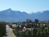
http://upload.wikimedia.org/wikipedia/commons/a/a3/Tulbagh_WC_ZA.jpg
http://upload.wikimedia.org/wikipedia/commons/0/07/UCT_Upper_Campus_landscape_view.jpg
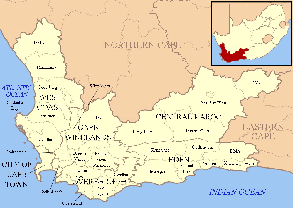
http://upload.wikimedia.org/wikipedia/commons/2/22/Map_of_the_Western_Cape_with_towns_and_roads.svg
http://upload.wikimedia.org/wikipedia/commons/8/8c/Map_of_the_Western_Cape_with_municipalities_labelled.svgWestern Cape
The Western Cape is a province in the south west of South Africa. The capital is Cape Town. Prior to 1994, the region that now forms the Western Cape was part of the huge (and now defunct) Cape Province. Prior to the formation of the Union of South Africa in 1910, it was called the Cape Colony (see the History of Cape Colony).
History since 1994
In 1994, after the inauguration of South Africa's first black president, Nelson Mandela, the Cape Province was broken up into three provinces: Western Cape, Northern Cape and Eastern Cape (which encompasses the former Xhosa homelands of Transkei and Ciskei). However, the Western Cape set itself apart early in post-apartheid South African history by being one of the two provinces to have rejected an ANC mandate (the other being KwaZulu-Natal) by electing former Cape Province Law and Order minister Hernus Kriel (NP) as the first premier of the Western Cape. It would be dominated by the National Party, and its successor, until the party's announced 2004 merger with the ANC, which brought ex-premier Ebrahim Rasool to power.Law and Government
The capital of the Western Cape is the City of Cape Town. The Premier of the Western Cape is Helen Zille while the Director-General of the provincial administration is Virginia Petersen.The Constitution of the Western Cape was adopted in 1998 and is published in the official languages of the province: Afrikaans, English and Xhosa.
The Western Cape Provincial Parliament is responsible for creating laws within its responsibilities as set out by the South African Constitution. Some of the issues dealt with cover agriculture, education, environment, health services, housing, language policies, tourism, trade, and welfare. The Legislature is housed in Cape Town and has a total of 42 members. The Fourth Parliament was elected in the election of 22 April 2009; 22 seats are held by the Democratic Alliance, 14 by the African National Congress, 3 by the Congress of the People, 2 by the Independent Democrats, and 1 by the African Christian Democratic Party.
Two Maps of the Western Cape:
Map 1 shows infrastructure; Map 2 shows the MunicipalitiesGeography
The Western Cape is bordered on the north by the Northern Cape, on the east by the Eastern Cape, on the south by the Indian Ocean, and on the west by the Atlantic Ocean. The subantarctic dependency of the Prince Edward Islands is included within the province's administration. The Breede, Berg and Olifants Rivers are major rivers of the province. The capital is Cape Town and other major cities include Stellenbosch, Worcester, Paarl, and George. The Garden Route and the Overberg are popular coastal tourism areas.
The Western Cape is exceptionally topographically diverse. Most of the province falls within the Cape Fold Belt, a range of sandstone folded mountains of Permian to Carboniferous age that range in height from 1000m to 2300m. The valleys between ranges are generally very fertile and contains alluvial loamy to clay soils. The far interior forms part of the Karoo Basin and is generally arid and hilly with a sharp escarpment in the north. Coastal areas range from sandy between capes, to rocky to steep and mountainous in places. The Western Cape is also the southernmost region of the African continent with Cape Agulhas as its southernmost point, only 3800km from the Antarctic coastline.
The total land area is 129,370 km², about 10.6% of the country’s total. It is roughly the size of England or the US state of Louisiana.
Vegetation is also extremely diverse, with one of the world's seven floral kingdoms almost exclusively endemic to the province, namely the Cape Floral Kingdom, most of which is covered by Fynbos (Afrikaans: Fine Bush). It is extremely rich in species diversity, with more plant species occurring on Table Mountain than the entire United Kingdom. It is characterised by various types of shrubs, thousands of flowering plant species and some small trees.
The arid interior is dominated by Karoo drought-resistant shrubbery. The West Coast and Little Karoo are semi-arid regions and are typified by many species of succulents and drought-resistant shrubs and acacia trees. The Garden Route is extremely lush, with temperate rainforest (or Afromontane Forest) covering many areas adjacent to the coast and along the mountain ranges. Typical species are hardwoods of exceptional height, such as Yellowwood, Stinkwood and Ironwood trees.
Municipalities
Map of the municipalities of the Western CapeThe Western Cape is made up of one metropolitan municipality, and five district municipalities subdivided into 24 local municipalities.
* City of Cape Town
* West Coast District: Matzikama; Cederberg; Bergrivier; Saldanha Bay; Swartland
* Cape Winelands District: Witzenberg; Drakenstein; Stellenbosch; Breede Valley; Breede River
* Overberg District: Theewaterskloof; Overstrand; Cape Agulhas; Swellendam
* Eden District: Kannaland; Hessequa; Mossel Bay; George; Oudtshoorn; Bitou; Knysna
* Central Karoo District: Laingsburg; Prince Albert; Beaufort WestCities and towns
The population figures quoted only include urbanised areas:Population 1,000,000++
Cape TownPopulation 50,000+
George; Oudtshoorn; Paarl; Stellenbosch; Swellendam; WorcesterPopulation 10,000+
Bredasdorp; Ceres; Hermanus; Knysna; Malmesbury; Montagu; Plettenberg Bay; Riversdale; Robertson; Tulbagh; WellingtonPopulation < 10,000
Arniston; Elim; Napier; StruisbaaiClimate
The Western Cape is also diverse climatologically, with many distinct micro- and macroclimates created by the varied topography and the influence of both the Indian (warm water) and Atlantic (cold water) oceans, thus climatic statistics can vary wildly over very short distances. Most of the province is considered to have a Mediterranean climate with cool, wet winters and warm, dry summers. The interior Karoo has a semi-arid climate with cold, frosty winters and hot summers with occasional thunderstorms. The Garden Route and the Overberg on the south coast have a maritime climate with cool, moist winters and mild, moist summers. Mossel Bay in the Garden Route is considered to have the second mildest climate worldwide after Hawaii.Thunderstorms are generally rare in the province, except in the Karoo interior, with most precipitation being of a frontal or orographic nature. Extremes of heat and cold are common inland, but rare near the coast. Snow is a common winter occurrence on the higher lying ground, however frost is relatively rare in coastal areas and many of the heavily cultivated valleys.
The dependency of the Prince Edward Islands are subantarctic islands, which experience year-round cool to cold temperatures with high precipitation and little annual deviation on both accounts.
* Cape Town Int'l Airport averages: January maximum: 26°C (min: 16°C), July maximum: 18°C (min: 7°C), annual rainfall: 515mm Kirstenbosch, Cape Town annual rainfall: 1395mm
* George averages: January maximum: 25°C (min: 15°C), July maximum: 19°C (min: 7°C), annual rainfall: 715mm
* Marion Island (Prince Edward Group) averages: January maximum: 10°C (min: 5°C), July maximum: 6°C (min: 1°C), annual rainfall: 2401mmEconomy
The Western Cape’s total GDP is the third-highest contribution to the country’s total, at 14.6%. The largest industry is the clothing and textile industry, which employs over 170,000 people. The textile industry is presently declining in importance, due to competition with cheaper Eastern producers, such as China. High-tech industries, international call centres, fashion design, advertising and TV production are niche industries rapidly gaining in importance. The province also has a substantially lower unemployment rate than the other provinces; 17.1% of the working population is unemployed.The province has recently grown a massive tourism industry, with the majority of international tourist arrivals visiting the province, with Cape Town, Garden Route and the Winelands being popular tourist destinations. There were 1,535,903 international arrivals in 2004 with continued growth annually. Domestic tourism is also on the rise, as low-cost air carriers such as Kulula and 1Time making travel more affordable to more South Africans.
Infrastructure and communications
The Western Cape has an excellent network of highways comparable with any first-world country. The primary highways are the N1 (from Cape Town to Three Sisters, continuing outside the province towards Bloemfontein and Johannesburg), N2 (from Cape Town to Bloukrans River, towards Port Elizabeth), N7 (from Cape Town to Bitterfontein, continuing towards Springbok and Namibia) and N12 (from George to Three Sisters, continuing towards Kimberley and Johannesburg). Other routes are the 'R' roads which connect the smaller towns. All major roads are tarred with major rural gravel roads well maintained. Limited access motorways are limited to the Cape Metropolitan Area, Winelands and Garden Route, however due to the low population density of the remainder of the province, the highways remain efficient and high-speed, except during peak holiday travel seasons, when travel can be slow-going in places due to heavy traffic.
Telecommunications in the province is highly sophisticated; however, landline telephone communications still leaves much to be desired (much due to the Telkom telecommunications parastatal's monopoly). All areas have internet access. Mobile cellular communications is world class with reception in all densely populated rural areas, all urban areas and along all major routes (including mountain passes and tunnels). All national banks are represented almost everywhere, including even the smallest of towns.
Demographics
As of the census of 2001, there were 4,524,336 people in the Western Cape, living in 1,173,302 households. The population density was 34.97/km² and the household density 9.07/km². In terms of race, 53.91% of people described themselves as Coloured, 26.68% as Black, 18.41% as White, and 1.00% as Indian or Asian 1.00%.Age distribution in the province is spread out, with 27.3% under the age of 15, 19.4% from 15 to 24, 32.9% from 25 to 44, 15.2% from 45 to 64, and 5.2% who are 65 years of age or older. The median age is 26 years. For every 100 females there are 94.0 males. For every 100 females age 18 and over, there are 91.3 males.
In the province 55.3% of residents speak Afrikaans at home, 23.7% speak Xhosa, 19.3% speak English, and less than 2% speak another language.
81.8% of residents are Christian, 9.0% have no religion, 6.5% are Muslim, 0.4% are Jewish, and 0.2% are Hindu. 2.1% have other or undetermined beliefs.
5.7% of residents aged 20 and over have received no schooling, 15.2% have had some primary school, 7.9% have completed only primary school, 36.5% have had some high school education, 23.4% have finished only high school, and 11.2% have an education higher than the high school level. Overall, 34.6% of residents have completed high school.
63.1% of housing units have a telephone and/or cell-phone in the dwelling, 34.2% have access to a phone nearby, and 2.7% have access that is not nearby or no access. 86.5% of households have a flush or chemical toilet. 87.8% have refuse removed by the municipality at least once a week and 1.4% have no rubbish disposal. 67.5% have running water inside their dwelling, 85.2% have running water on their property, and 98.3% have access to running water. 78.8% of households use electricity for cooking, 73.4% for heating, and 88.0% for lighting. 79.1% of households have a radio, 74.1% have a television, 18.2% own a computer, 73.5% have a refrigerator, and 41.4% have a cell-phone.
17.1% of the population aged 15-65 is unemployed. Of the unemployed persons, 53.4% are Black, 43.0% are Coloured, 0.4% are Indian/Asian, and 3.2% are White. 23.3% of Black are unemployed, 9.3% of Coloureds, 5.0% of Indians/Asians, and 2.0% of Whites.
The median annual income of working adults aged 15-65 in the Western Cape is R 18,703. Males have a median annual income of R 21,048 versus R 17,035 for females. The median annual income by race is R 12,213 for Blacks, R 16,354 for Coloureds, R 42,803 for Indians/Asians, and R 64,968 for Whites.
Education
The Western Cape is the most highly educated province with a very skilled workforce in comparison to any other African region. The high school graduation rate is consistently around 80%, higher than any other province. The province also boasts three internationally acclaimed universities, namely the University of Cape Town, Stellenbosch University and the University of the Western Cape.Universities: Stellenbosch University; University of Cape Town; University of the Western Cape (Cape Town) ; Cape Peninsula University of Technology (Bellville, Cape Town)
Other Educational Institutions: South African Military Academy (Saldanha)Web Reference: http://en.wikipedia.org/wiki/Western_Cape
Cape Town South Africa Map
 Editor for Asisbiz: Matthew Laird Acred
If you love our website Please donate so we can make this site even better !!
Please donate so we can make this site even better !!
