 |
 |
 |
 |
 |
 |
 |
 |
 |
 |
 |
 |
 |
 |
 |
 |
 |
 |
 |
 |
 |
 |
 |
 |
 |
 |
 |
 |
 |
 |
 |
 |
 |
 |
 |
 |
 |
 |
 |
 |
 |
 |
 |
 |
 |
 |
 |
 |
 |
 |
 |
The South Island (Māori: Te Wai Pounamu)
The South Island (Māori: Te Wai Pounamu) is the larger of the two major islands of New Zealand, the other being the more populous North Island.
The South Island is often called 'The Mainland'. Today this expression is used humorously, although still with pride by 'Mainlanders', since while it is a somewhat larger landmass than the North Island. only about a quarter of New Zealand's four million inhabitants live in the South Island. However, in the early stages of European (Pākehā) settlement of the country, the South Island was pre-eminent, with the majority of the European population and wealth focused there due to gold rushes. It was not until the early 20th century that the North Island population overtook the South, with 56% of the population living in the North in 1911.
History
Early inhabitants of the South Island were the Waitaha. They were largely absorbed via marriage and conquest by the Kāti Mamoe in the 1500s.Ngāti Mamoe were in turn largely absorbed via marriage and conquest by the Ngāi Tahu who migrated south in the seventeenth century. While today there is no distinct Ngati Mamoe organisation, many Ngai Tahu have Ngati Mamoe links in their whakapapa and, especially in the far south of the island.
Around the same time a group of Māori migrated to Rekohu (the Chatham Islands), where, by adapting to the local climate and the availability of resources, they developed a culture known as Moriori — related to but distinct from Māori culture in mainland New Zealand. A notable feature of the Moriori culture, an emphasis on pacifism, proved disadvantageous when Māori warriors arrived in the 1830s aboard a chartered European ship.
The first Europeans known to reach the South Island were the crew of Dutch explorer Abel Tasman who arrived in his ships Heemskerck and Zeehaen. Tasman anchored in Golden Bay, at the northern end of the island, (he named it Murderers Bay) in December 1642 and sailed northward to Tonga following a clash with local Māori. Tasman sketched sections of the two main islands' west coasts. Tasman called them Staten Landt, after the States-General of the Netherlands, and that name appeared on his first maps of the country. Dutch cartographers changed the name to Nova Zeelandia in Latin, from Nieuw Zeeland, after the Dutch province of Zeeland. It was subsequently Anglicised as New Zealand by British naval captain James Cook of HM Bark Endeavour who visited the islands more than 100 years after Tasman during (1769–1770).
In the early 18th century, Ngāi Tahu a Māori tribe who originated on the east coast of the North Island began migrating to the northern part of the South Island. There they and Kāti Mamoe fought Ngāi Tara and Rangitāne in the Wairau Valley. Ngāti Māmoe then ceded the east coast regions north of the Clarence River to Ngāi Tahu. Ngāi Tahu continued to push south, conquering Kaikoura. By the 1730s, Ngāi Tahu had settled in Canterbury, including Banks Peninsula. From there they spread further south and into the West Coast.
In 1827-1828 Ngāti Toa under the leadership of Te Rauparaha successfully attacked Ngāi Tahu at Kaikoura. Ngāti Toa then visited Kaiapoi, ostensibly to trade. When they attacked their hosts, the well-prepared Ngāi Tahu killed all the leading Ngāti Toa chiefs except Te Rauparaha. Te Rauparaha returned to his Kapiti Island stronghold. In November 1830 Te Rauparaha persuaded Captain John Stewart of the brig Elizabeth to carry him and his warriors in secret to Akaroa, where by subterfuge they captured the leading Ngāi Tahu chief, Te Maiharanui, and his wife and daughter. After destroying Te Maiharanui's village they took their captives to Kapiti and killed them. John Stewart, though arrested and sent to trial in Sydney as an accomplice to murder, nevertheless escaped conviction.
In the summer of 1831–1832 Te Rauparaha attacked the Kaiapoi pā (fortified village). After a three-month siege, a fire in the pā allowed Ngāti Toa to overcome it. They then attacked Ngāi Tahu on Banks Peninsula and took the pā at Onawe. In 1832-33 Ngāi Tahu retaliated under the leadership of Tuhawaiki and others, attacking Ngāti Toa at Lake Grassmere. Ngāi Tahu prevailed, and killed many Ngāti Toa, although Te Rauparaha again escaped. Fighting continued for a year or so, with Ngāi Tahu maintaining the upper hand. Ngāti Toa never again made a major incursion into Ngāi Tahu territory.
By 1839 Ngāi Tahu and Ngāti Toa established peace and Te Rauparaha released the Ngāi Tahu captives he held. Formal marriages between the leading families in the two tribes sealed the peace.
On 17 June 1843, Māori natives and the British settlers clashed at Wairau in what became known as the Wairau Affray. Also known as the Wairau Massacre in most older texts, it was the first serious clash of arms between the two parties after the signing of the Treaty of Waitangi and the only one to take place in the South Island. Four Māori died and three were wounded in the incident, while among the Europeans the toll was 22 dead and five wounded. Twelve of the Europeans were shot dead or clubbed to death after surrendering to Māori who were pursuing them.
In the 1870s and 1880s, several thousand Chinese men, mostly from the Guangdong province, migrated to New Zealand to work on the South Island goldfields. Although the first Chinese migrants had been invited by the Otago Provincial government they quickly became the target of hostility from white settlers and laws were enacted specifically to discourage them from coming to New Zealand.
Naming and usage
Although the island has been known as the South Island for many years, the New Zealand Geographic Board has found that, along with the North Island, it has no official name. The board intends to make South Island the island's official name, along with an alternative Māori name. Although several Māori names have been used, Maori Language Commissioner Erima Henare sees Te Wai Pounamu as the most likely choice. This Māori name for the South Island, meaning 'The Water(s) of Greenstone', possibly evolved from Te Wāhi Pounamu which means 'The Place Of Greenstone'. The island is also known as Te Waka a Māui which means 'Māui's Canoe'. In Māori legend, the South Island existed first, as the boat of Maui, while the North Island was the fish that he caught.In the 19th century, some maps named the South Island as Middle Island or New Munster, and the name South Island or New Leinster was used for today's Stewart Island/Rakiura. In 1907 the Minister for Lands gave instructions to the Land and Survey Department that the name Middle Island was not to be used in future. 'South Island will be adhered to in all cases'.
The South Island takes the definite article when used as a noun whereas maps, headings or tables and adjectival expressions use South Island. This pattern can be found in a number of other names, such as the United Kingdom, the Vatican and the Internet.
Examples:
* My mother lives in the South Island
* The North Island is smaller in area than the South Island
* I'm visiting the South Island
* The major South Island peaks are all in the Southern AlpsNote also that places are said to be in the South Island rather than on the South Island.
Politics
The South Island is guaranteed 16 of the 69 electorates in the New Zealand House of Representatives. In addition, 10 list MPs are based in the South Island, including the current Deputy Prime Minister.Local government regions
There are seven local government regions covering the South Island and all its adjacent islands and territorial waters. Four are governed by an elected regional council, while three are governed by territorial authorities (the second tier of local government) which also perform the functions of a regional council and thus are known as unitary authorities. There is one exception to this, Nelson City, is governed by an individual Territorial authority to its region (Tasman Region). The Chatham Islands Council is often counted by many as a unitary authority, but it is officially recognised as a part of the region of Canterbury.* Canterbury
* Marlborough
* Nelson
* Otago
* Southland
* Tasman
* West CoastTerritorial authorities
There are 25 territorial authorities within the South Island: 4 city councils, 20 district councils and the Chatham Islands Council. Four territorial authorities (Nelson City Council, Tasman and Marlborough District Councils and the Chatham Islands Council) also perform the functions of a regional council and thus are known as unitary authorities.* Tasman District Council (unitary authority)
* Nelson City Council (unitary authority)
* Marlborough District Council (unitary authority)
* West Coast Regional Council
o Buller District Council
o Grey District Council
o Westland District Council
* Canterbury Regional Council (Environment Canterbury)
o Kaikoura District Council
o Hurunui District Council
o Selwyn District Council
o Waimakariri District Council
o Christchurch City Council
o Ashburton District Council
o Mackenzie District Council
o Timaru District Council
o Waitaki District Council (part)
o Waimate District Council
* Otago Regional Council
o Queenstown Lakes District Council
o Central Otago District Council
o Waitaki District Council (part)
o Dunedin City Council
o Clutha District Council
* Southland Regional Council (Environment Southland)
o Southland District Council
o Gore District Council
o Invercargill City Council
* Stewart Island/Rakiura
o Southland Regional Council (Environment Southland)
* Chatham Islands
o Chatham Islands Council (district)Political parties
This is a list of Political parties, past and present, who have their headquarters in the South Island.
* Aotearoa Legalise Cannabis Party
* Imperial British Conservative Party
* National Democrats Party
* New Zealand Democratic Party
* New Zealand Progressive Party
* South Island Party
* South Island Party (2008)People
Further information: Cities and Towns of the South Island and List of famous South IslandersPopulation
Compared to the more populated and multi-ethnic North Island, the South Island has a smaller, more homogeneous resident population of 1,017,300 (June 2008 estimate). At the 2001 Census, over 91 percent of people in the South Island said they belong to the European ethnic group, compared with 80.1 percent for all of New Zealand.Economy
The South Island had an estimated sub-national GDP of US$27.8 billion (as of 2003).The main industry groups within the South Island are manufacturing, agriculture, mining, construction, electricity, gas and water supply, education, health and community services.
Stock exchanges
Due to the Gold Rush of the 1870s, the South Island had regional stock exchanges in Christchurch, Dunedin and Invercargill – all of which were affiliated in the Stock Exchange Association of New Zealand. However, in 1974 these regional exchanges were amalgamated to form one national stock exchange, the New Zealand Stock Exchange (NZSE). On 30 May, 2003, New Zealand Stock Exchange Limited formally changed its name to New Zealand Exchange Limited, trading as NZX.Today, the Deloitte South Island Index is compiled quarterly from publicly available information provided by NZX, Unlisted and Bloomberg. It is a summary of the movements in market capitalisation of each South Island based listed company. A company is included in the Index where either its registered office and/or a substantial portion of its operations are focused on the South Island.
Trade unions
There are several South Island based trade union organisations. They are:
* Furniture, Manufacturing & Associated Workers Union
* New Zealand Building Trades Union
* New Zealand Meat & Related Trades Workers Union
* Southern Amalgamated Workers' UnionTourism
The main tourism destinations in the South Island are;
* Nelson and Tasman District
* Marlborough
* West Coast
* Kaikoura
* Hanmer Springs
* Christchurch and Canterbury
* Dunedin
* Southland Region and Stewart Island/Rakiura
* Queenstown, Wanaka and Central Otago
* Fiordland
* Milford SoundSki areas and resorts
Nelson Lakes
* Rainbow
* Mount RobertCanterbury
* Fox Peak (club skifield)
* Hanmer Springs Ski Area (club skifield)
* Mount Lyford
* Mount Potts (heliskiing and snowcatting only)
* Mount Hutt
* Mount Dobson
* Ohau
* Porter Heights
* Round Hill
* Tasman Glacier (Heliski)
* Temple Basin (club skifield)
* Craigieburn Range
o Broken River (club skifield)
o Craigieburn Valley (club skifield)
o Mount Cheeseman (club skifield)
o Mount Olympus (club skifield)Otago
* Coronet Peak
* Invincible Snowfields (helicopter access only)
* The Remarkables
* Around Wanaka
o Cardrona Alpine Resort
o Treble Cone
o Snow Park
o Snow Farm (cross-country skiing only)Transport
Road transport
The South Island has a State Highway network of 4,921 km.Rail transport
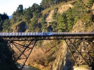
The South Island's railway network has two main lines, two secondary lines, and a few branch lines. The Main North Line from Picton to Christchurch and the Main South Line from Lyttelton to Invercargill via Dunedin together comprise the South Island Main Trunk Railway. The secondary Midland Line branches from the Main South Line in Rolleston and passes through the Southern Alps via the Otira Tunnel to the West Coast and its terminus in Greymouth. In Stillwater, it meets the other secondary route, the Stillwater - Westport Line, which now includes the Ngakawau Branch. A number of other secondary routes are now closed, including the Otago Central Railway, the isolated Nelson Section, and the interdependent Waimea Plains Railway and Kingston Branch. An expansive network of branch lines once existed, especially in Canterbury, Otago, and Southland, but these are now almost completely closed. The branch lines that remain in operation serve ports (Bluff Branch and Port Chalmers Branch), coal mines (Ohai Branch and Rapahoe Branch), and a dairying factory (Hokitika Branch). The first 64 km of the Otago Central Railway remain in operation for tourist trains run by the Taieri Gorge Railway (TGR). The most significant freight is coal from West Coast mines to the port of Lyttelton for export.Passenger services were once extensive. Commuter trains operated multiple routes around Christchurch and Dunedin, plus a service between Invercargill and Bluff. Due to substantial losses, these were cancelled between the late 1960s and early 1980s. The final services to operate ran between Dunedin and Mosgiel, and they ceased in 1982. Regional passenger trains were once extensive, but are now limited to the TranzCoastal from Christchurch to Picton and the TranzAlpine from Christchurch to Greymouth. The Southerner between Christchurch and Invercargill, once the flagship of the network, was cancelled on 10 February 2002. Subsequently, the architecturally significant Dunedin Railway Station has been used solely by the TGR's tourist trains, the Taieri Gorge Limited along the Otago Central Railway and the Seasider to Palmerston. Rural passenger services on branch lines were provided by mixed trains and Vulcan/88 seater railcars but the mixeds had largely ceased to exist by the 1950s and the railcars were withdrawn in the mid-1970s.
The South Island saw the final use of steam locomotives in New Zealand. Locomotives belonging to classes long withdrawn elsewhere continued to operate on West Coast branches until the very late 1960s, when they were displaced by DJ class diesels. In comparison to most countries, where steam locomotives were last used on insubstantial rural and industrial operations, the very last services run by steam locomotives were the premier expresses between Christchurch and Invercargill: the South Island Limited until 1970 and the Friday and Sunday night services until 1971. This was due to the carriages being steam-heated. The final steam-hauled service in New Zealand, headed by a member of the JA class, ran on 26 October 1971.
Water transport
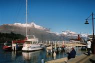
The South Island is separated from the North Island by Cook Strait, 24 km wide at its narrowest point, but requiring a 70 km ferry trip to cross.Ports and harbours
* Container ports: Lyttelton (Christchurch), Port Chalmers (Dunedin)
* Other ports: Nelson, Picton, Westport, Greymouth, Timaru, Bluff.
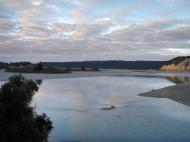
* Harbours: Akaroa, Otago Harbour, Half Moon Bay (Stewart Island/Rakiura), Milford Sound.
* Freshwater: Queenstown and Kingston (Lake Wakatipu), Te Anau and Manapouri (Lake Manapouri)Air transport -- Airport
LOCATION ICAO IATA AIRPORT NAME Alexandra NZLX ALR Alexandra Aerodrome Ashburton NZAS ASG Ashburton Aerodrome Balclutha NZBA Balclutha Aerodrome Blenheim NZWB BHE Blenheim Airport (Woodbourne) Chatham Islands NZCI CHT Chatham Islands / Tuuta Airport Christchurch NZCH CHC Christchurch International Airport (long-distance) Cromwell NZCS Cromwell Racecourse Aerodrome Dunedin NZDN DUD Dunedin International Airport (limited) Gore NZGC Gore Aerodrome Greymouth NZGM GMN Greymouth Airport Haast NZHT Haast Aerodrome Hokitika NZHK HKK Hokitika Airport Invercargill NZNV IVC Invercargill Airport Kaikoura NZKI KBZ Kaikoura Aerodrome Lake Pukaki NZGT GTN Glentanner Aerodrome Milford Sound NZMF MFN Milford Sound Airport Mount Cook NZMC MON Mount Cook Aerodrome Motueka NZMK MZP Motueka Aerodrome Nelson NZNS NSN Nelson Airport Oamaru NZOU OAM Oamaru Aerodrome Picton NZPN PCN Picton Aerodrome Queenstown NZQN ZQN Queenstown Airport (limited) Rangiora NZFF Forest Field Aerodrome Stewart Island/Rakiura NZRC SZS Ryans Creek Aerodrome Takaka NZTK KTF Takaka Aerodrome Te Anau / Manapouri NZMO TEU Manapouri Aerodrome Timaru NZTU TIU Richard Pearse Airport Twizel NZUK TWZ Pukaki Aerodrome Wanaka NZWF WKA Wanaka Airport Westport NZWS WSZ Westport Airport Wigram NZWG Wigram Aerodrome Geography
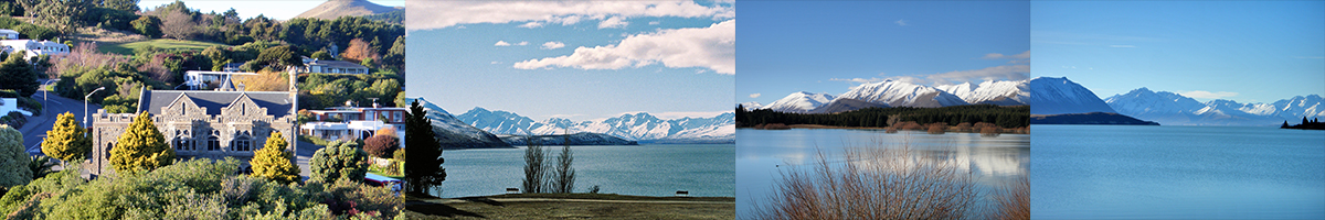
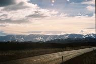
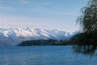
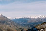
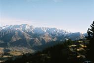
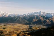
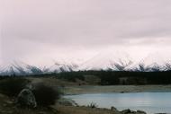
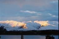
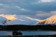
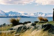
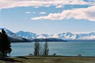
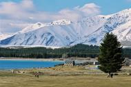
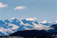
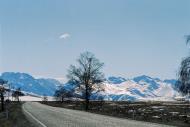
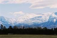
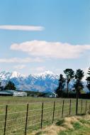
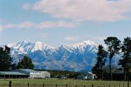
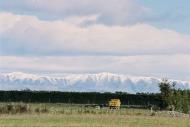
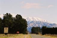
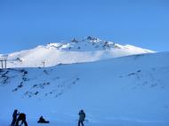
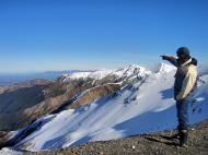
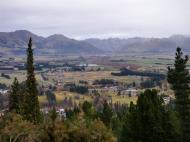
The South Island with an area of 151,215 km² (58,093 square miles) is the largest land mass of New Zealand, it contains about one quarter of the New Zealand population and is the world's 12th-largest island. It is divided along its length by the Southern Alps, the highest peak of which is Aoraki/Mount Cook at 3754 metres (12,316 ft). There are eighteen peaks of more than 3000 metres (9800 ft) in the South Island. The east side of the island is home to the Canterbury Plains while the West Coast is famous for its rough coastlines, very high proportion of native bush, and Fox and Franz Josef Glaciers.Climate
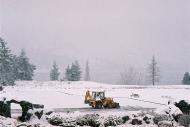
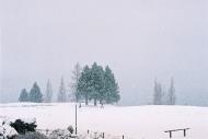
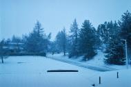
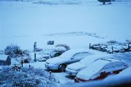
The climate in the South Island is mostly temperate. The Mean temperature for the South Island is 8 °C (46 °F). January and February are the warmest months while July is the coldest.Most areas have between 600 and 1600 mm of rainfall with the most rain along the West Coast and the least rain on the East Coast, predominantly on the Canterbury Plains. Christchurch is the driest city receiving about 640 mm (25 in) of rain per year.
There are three main factors that influence New Zealand's climate:
* Its latitude zone location where the prevailing winds flow westerly.
* Its oceanic environment.
* The mountains, especially the Southern Alps.Geology
National Parks:
Abel Tasman National Park; Aoraki/Mount Cook National Park; Fiordland National Park; Kahurangi National Park; Mount Aspiring National Park; Nelson Lakes National Park; Paparoa National Park; Rakiura National Park; Westland National ParkOther Native Reserves and Parks
Hakatere Conservation ParkGeographic features
Arthur's Pass; Banks Peninsula; Catlins; Doubtful Sound; Farewell Spit; Haast Pass; Mackenzie Basin; Marlborough Sounds; Milford Sound; Southern Alps; Slope Point; Spenser MountainsGlaciers: Fox Glacier; Franz Josef Glacier
Rivers: Hokitika River
Education
The South Island has several tertiary level institutions:
Aoraki Polytechnic; Christchurch Polytechnic Institute of Technology; Lincoln University; Nelson Marlborough Institute of Technology; Otago Polytechnic; Southern Institute of Technology; Tai Poutini Polytechnic; Telford Rural Polytechnic; University of Canterbury; University of OtagoHealthcare
Healthcare in the South Island is provided by six District Health Boards (DHBs). Organized around geographical areas, of varying population sizes, they are not coterminous with the Local Government Regions: Canterbury DHB; Nelson Marlborough DHB; Otago DHB; South Canterbury DHB; Southland DHB; West Coast DHBMedia
Ashburton Guardian; The Marlborough Express; The Nelson Mail; Otago Daily Times; The Press; Southland Times; The Timaru HeraldTelevision
45 South; Canterbury Television; Channel 9; CUE (Southland TV)Radio
Nelson stations
Current stations
Fresh FM; Impact 100; Mainland FM; Radio RobotPrevious stations
Cadbury Moro FM; Fifeshire FM - Rebranded as More FM; Radio Nelson - Rebranded as Classic Hits 89.8 & 90.4FM; The Planet 97FM - Replaced with ZMWest Coast stations
Current Stations
Coast FM - (no connection to Coast Radio Network. ; Z102 102.5FMPrevious stations
Radio Scenicland and later Scenicland FM - Rebranded as Classic Hits Scenicland FM.Canterbury stations
Current stations
91ZM - Operates local daytime show all other shows from the ZM network. Originally local until 2001. ; Country 88FM; Newstalk ZB - Local breakfast and morning show all other shows from Newstalk ZB network. ; Plains 96.9FM; Port FM (Timaru) ; Pulzar FM; Radio Ferrymead; RDU-FMPrevious stations
3ZB - Rebranded as Newstalk ZB; 3ZE (Ashburton) - Rebranded as Classic Hits 92.5 ZEFM; Channel Z - Operated local Channel Z station until 2001 when station was replaced with Auckland based network product. ; Fox FM (Ashburton) - Rebranded as Port FM; 99 Life FM - Original Life FM station; B98 FM - Rebranded as Classic Hits B98 and later Classic Hits 97.7; Lite FM - Rebranded as The Breeze; Radio Avon and later C93FM; Radio Caroline (Timaru) - Rebranded as Classic Hits 99FM; Blush 96.1 - Christchurch NZBS 'Live Sexy'Dunedin and East Otago stations
Current stations:
Big River Radio (Balclutha); Country Radio 88.7; Ear107; GoldRush1440 (Lawrence) ; Hills AM; Radio Clutha (Balclutha) ; Radio Dunedin; Radio One; RushFM (Lawrence)Previous stations
4XO - Rebranded as More FM; 4ZB and later ZBFM - Rebranded as Classic Hits 89FM; 93Rox; Radio Waitaki (Oamaru) - Rebranded as Classic Hits Radio Waitaki; Whitestone FM (Oamaru) - Rebranded as Port FMQueenstown and Central Otago stations
Current Stations
96.7 Blue Skies FM (Alexandra) ; Burn 729AM (Ranfurly) ; The Studio FM (Queenstown) ; Radio Wanaka (Wanaka)Previous stations:
Radio Central (Alexandra) - Rebranded as More FM; Resort Radio (Queenstown) - Rebranded as More FM; Q92FM (Queenstown) - Rebranded as Q92 The BreezeSouthland Radio stations
Current stations:
Country Radio 88.4; Hokonui Gold; Radio Southland 96.4Previous stations
4ZA - Rebranded as Classic Hits 98.8 ZAFM; Foveaux FM - Rebranded as More FM; eFM - Southern Institute of Technology student radio station that operated in 2001.Sport
A number of national or international sporting teams and events are based in the South Island, including:* Basketball: Canterbury Rams, Christchurch Sirens, Nelson Giants and the Otago Nuggets.
* Ice hockey: Canterbury Red Devils, Dunedin Thunder, Southern Stampede.
* Netball: Canterbury Tactix and the Southern Steel.
* Soccer: Canterbury United, Otago United.
* Rugby league: Canterbury Bulls
* Rugby union: Crusaders, Highlanders, Tasman Makos, Southland Stags, West Coast, Buller, South Canterbury, North OtagoInternational events hosted in the South Island include the National Basketball League, the ANZ Championship netball competition and the Super 14 rugby union competition.
The arts
Art galleries:
Centre of Contemporary Art; Christchurch Arts Centre; Dunedin Public Art GalleryMuseums:
Canterbury Museum; Ferrymead Heritage Park; Nelson Provincial Museum; Otago Museum; Otago Settlers Museum; Royal New Zealand Air Force Museum; Southland museum and art gallery; World of Wearable ArtFilm location
Several movies have been filmed (in large part) in the South Island, including the Lord of the Rings and 2005's The Chronicles of Narnia: The Lion, The Witch, and the Wardrobe.Web References: http://en.wikipedia.org/wiki/South_Island
South Island, New Zealand Map
 Editor for Asisbiz: Matthew Laird Acred
If you love our website Please donate so we can make this site even better !!
Please donate so we can make this site even better !!