 |
 |
 |
 |
 |
 |
 |
 |
 |
 |
 |
 |
 |
 |
 |
 |
 |
 |
 |
 |
 |
 |
 |
 |
Queenstown
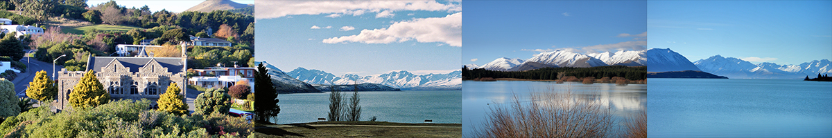
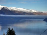
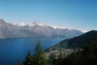
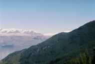
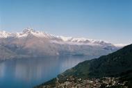
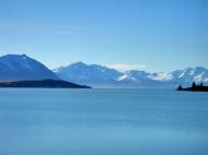
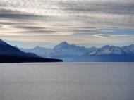
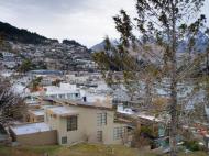
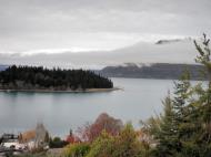
Queenstown is an international resort town in Otago in the south-west of New Zealand's South Island. It is built around an inlet on Lake Wakatipu, a long thin lake formed by glacial processes that is shaped like a staggered lightning bolt, and has spectacular views of nearby mountains.
There are various apocryphal accounts of how the town was named, the most popular suggesting that a local gold digger exclaimed that the town was 'fit for Queen Victoria'. It is now known for its commerce-oriented tourism, especially adventure and ski tourism. It is popular with young international and New Zealand travellers alike.
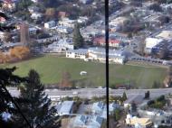
The town is the largest centre in Central Otago, and the third largest in Otago. There are a few administrative functions (such as primary healthcare) that are currently administered by the neighbouring province of Southland. According to the 2006 census, the usually resident population of the Queenstown urban area (including Frankton and Kelvin Heights) is 10422, an increase of 22.1% since 2001.
Its neighbouring towns and districts include Arrowtown, Wanaka, Alexandra, and Cromwell. The nearest cities are Dunedin and Invercargill.
The Queenstown-Lakes District has a land area of 8,704.97 km² (3,361.01 sq mi) not counting its inland lakes (Lake Hawea, Lake Wakatipu, and Lake Wanaka). It has an estimated resident population of 26,400 (June 2008 estimate).
Tourism
A resort town, Queenstown is a centre for adventure tourism. Skiing, jet boating, bungy jumping, mountain biking, tramping and fly fishing are all strong promotional themes.Queenstown is a major centre for snow sports in New Zealand, with people from all over the country and many parts of the world travelling to ski at the four main mountain skifields (Cardrona Alpine Resort, Coronet Peak, The Remarkables and Treble Cone).
A coal fired steamship that is nearly 100 years old, called the TSS Earnslaw, provides tourist trips on the lake.
In recent years, Queenstown's hostels have become a popular destination for tourists from all over the world. Queenstown provides adventure tourism during the day and a vibrant nightlife scene during the evenings.
Locally, Queenstown has a reputation as one of New Zealand's wine and cuisine centres. Neighbouring, historic Arrowtown also features excellent restaurants and bars, and Queenstown lies close to the centre of a small wine producing region, reputed to be the world's southernmost. Pinot noir produced in this area fetches premium prices.
Queenstown also now hosts an annual International Jazz Festival. Recent international performers include Anika Moa and Di Bird.
Queenstown also has a reputation for being the 'Adventure Capital of the World'.
Queenstown Airport has scheduled flights to Auckland, Christchurch and Sydney year-round and Wellington, Melbourne and Brisbane seasonally.
Queenstown and the surrounding area contains many locations used in the filming of the Lord of the Rings film trilogy.
Queenstown was used to film most of the 1988 film The Rescue
Highlights
* Lake Wakatipu - TSS Earnslaw
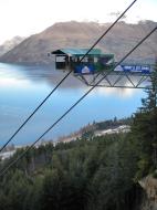
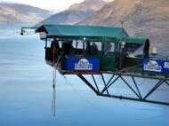
* Adventure Tourism, jetboats, bungy jump, skiing, river surfing, canyon swing, aerobatic flights, sky diving, mountain biking, paragliding
* Ben Lomond - a 1,748 m (5,735 ft) mountain whose summit is accessible with a few hours easy climbing giving magnificent views over Lake Wakatipu and the surroundng area
* A round of golf at Millbrook Resort - 150-year-old wheat farm, now a luxury resort.
* Cricket (new One Day International venue) and Golf
* Queenstown Airport at Frankton
* Skyline Gondola and luge
* Queenstown Winter Festival
* Goldmining, Arrowtown, Central Otago history, sheep farming and Walter Peak station.
* Southern Lakes District & Milford Sound/Homer Tunnel
* Glenorchy & Routeburn trackPanorama of the view from the Remarkables towards Queenstown Airport, with Queenstown beyond.
Climate
Queenstown has an alpine climate with winters that have clear blue skies and snow capped mountains. Summer has long warm days with temperatures that can reach 30°C (2007/2008).Transport
Queenstown is accessible by road and air but not by rail.As a resort centre, there are many bus services that operate into Queenstown, with most being for package tours, but daily services for the local or itinerant are available to/from Invercargill, Dunedin and Christchurch which are the main cities closest to Queenstown.
Queenstown has an international airport with flights from Australia by Air New Zealand and Qantas and in particular, from Brisbane, Melbourne and Sydney (the frequency is much increased over the ski season). Domestic flights operate from Auckland, Wellington and Christchurch. Due to sustained growth, expansion of the airport terminal was undertaken in 2005 and 2006, with more construction currently ongoing.
Queenstown Airport is New Zealand's busiest helicopter base, and is also heavily utilised for tourist 'flightseeing', especially to Milford Sound and Mount Cook, using both fixed and rotary wing aircraft.
The primary road access to the Queenstown area is via State Highway 6 (SH6), which travels from Cromwell through the Kawarau Gorge to Frankton, where a 9-km spur (SH6A) leads to the CBD and connects with the Glenorchy Road. SH6 continues south, crossing the Kawarau river before heading down the eastern side of Lake Wakatipu to Kingston before crossing the provincial boundary and emerging on the plains of Southland. A difficult road over the Crown Range leads to Cardrona skifield and Wanaka, and is New Zealand's highest paved public road.
Queenstown is the departure point for a large number of day trips to the similarly famous Milford Sound which entails a return trip of approximately 12 hours.
Web References: http://en.wikipedia.org/wiki/Queenstown,_New_Zealand
Otago
Flag Otago New Zealand
Otago is a region of New Zealand in the south of the South Island. It has an area of approximately 32,000 square kilometres (12,000 sq mi) making it the country's second largest region. It has a population of 203,500 from the June 2008 estimate.
The name 'Otago' is an old southern Maori word whose North Island dialect equivalent is 'Otakou', introduced to the south by Europeans in the 1840s. 'Otago' is also the old name of the European settlement on the Otago Harbour, established by the Weller Brothers in 1831.The place later became the focus of the Otago Association, an offshoot of the Free Church of Scotland, notable for its high-minded adoption of the principle that ordinary people should choose their ministers, not the landowner.
Major centres of what is now the Otago Region of the old province include Dunedin (the principal city of the region), Oamaru (made famous by Janet Frame), Balclutha, Alexandra, and the major tourist centres Queenstown and Wanaka. Kaitangata in South Otago is a prominent source of coal. The Waitaki and Clutha rivers also provide much of the country's hydroelectric power. Some parts of the area originally covered by Otago Province are now administered as part of Southland Region (qv).
New Zealand's first university, The University of Otago, was founded in 1869 as the provincial university in Dunedin.
The Central Otago area produces award winning wines made from varieties such as the Pinot Noir, Chardonnay, Sauvignon Blanc, Merlot, and Riesling grapes. Central Otago has an increasing reputation as New Zealand’s leading pinot noir region.
The region is administered by the Otago Regional Council.
History of Otago
The Otago Settlement, an outgrowth of the Free Church of Scotland, materialised in March 1848 with the arrival of the first two immigrant ships from Greenock on the Firth of Clyde -- the John Wickliffe and the Philip Laing. Captain William Cargill, a veteran of the Peninsular War, was the secular leader: Otago citizens subsequently elected him to the office of provincial Superintendent after the provinces were created in 1852. The Otago Province was the whole of New Zealand from the Waitaki river south, including Stewart Island and the sub-antarctic islands. It included the territory of the later Southland province and also the much more extensive lands of the modern Southland Region.Initial settlement was concentrated on the port and city, then expanded, notably to the south-west, where the fertile Taieri Plains offered good farmland. The 1860s saw rapid commercial expansion after Gabriel Read discovered gold at Gabriel's Gully near Lawrence, and the Central Otago goldrush ensued. Veterans of goldfields in California and Australia, plus many other fortune-seekers from Europe, North America and China, poured into the then Province of Otago, eroding its Scottish Presbyterian character. Further gold discoveries at Clyde and on the Arrow River round Arrowtown led to a boom, and Otago became for a period the cultural and economic centre of New Zealand. New Zealand's first daily newspaper, the Otago Daily Times, originally edited by Julius Vogel, dates from this period.
The Province of Southland separated from Otago Province and set up its own Provincial Council at Invercargill in 1861. After difficulties ensued, Otago re-absorbed it in 1870. Its territory is included in the southern region of the old Otago Province which is named after it and is now the territory of the Southland region.
The provincial governments were abolished in 1876 and replaced by other forms of local authority, including counties. Two in Otago were named after the Scottish independence heroes Wallace and Bruce.From this time the national limelight gradually shifted northwards.
Geography
Beginning in the west, the geography of Otago consists of high alpine mountains. The highest peak in Otago is Mount Aspiring, which is on the Main Divide. From the high mountains the rivers discharge into large glacial lakes. In this part of Otago glacial activity - both recent and very old - dominates the landscape, with large 'U' shaped valleys and rivers which have high sediment loads. River flows also vary dramatically, with large flood flows occurring after heavy rain. Lakes Wakatipu, Wanaka and Hawea form the sources of the Clutha, the largest river (by discharge) in New Zealand. The Clutha flows through Otago and discharges near Balclutha.Travelling east from the mountains, the Central Otago drylands predominate. These are dominated by the block mountains, upthrust schist mountains. In contrast to Canterbury, where the Northwest winds blow across the plains without interruption, in Otago the block mountains impede and dilute the effects of the Nor'wester.
The main Central Otago Centres, such as Alexandra and Cromwell, are found in the intermontane basins between the block mountains. The schist bedrock influence extends to the eastern part of Otago, where remnant volcanics mark its edge. The remains of the most spectacular of these are the Miocene volcanics centred on Otago Harbour. Elsewhere, basalt outcrops can be found along the coast and at other sites.
Climate
Weather conditions vary enormously across Otago, but can be broken into two broad types: the coastal climate of the coastal regions and the more continental climate of the interior.Coastal regions of Otago are subject to the alternating warm and dry/cool and wet weather patterns common to the interannual Southern oscillation. This oscillation produces an irregular short cycle of weather which repeats roughly every week, with three or four days of fine weather followed by three or four days of cooler, damp conditions. Drier conditions are often the result of the northwesterly föhn wind, which dries as it crosses the Southern Alps. Wetter air is the result of approaching low-pressure systems which sweep fronts over the country from the southwest. A common variant in this pattern is the centring of a stationary low-pressure zone to the southeast of the country, resulting in long-lasting cool, wet conditions. These have been responsible for several notable historical floods, such as the 'hundred year floods' of October 1878 and October 1978. Typically, winters are cool and wet. Snow can fall and settle to sea level in winter, especially in the hills and plains of South Otago. Summers, by contrast, tend to be warm and dry, with temperatures often reaching the mid to high 20s Celsius.
In Central Otago cold frosty winters are succeeded by hot dry summers. Central Otago's climate is the closest approximation to a continental climate anywhere in New Zealand. This climate is part of the reason why Otago is a successful wine-growing region. This inland region is one of the driest regions in the country, sheltered from prevailing rain-bearing weather conditions by the high mountains to the west and hills of the south. Summers can be hot, with temperatures often approaching or exceeding 30 degrees Celsius; winters, by contrast, are often bitterly cold - the township of Ophir in Central Otago holds the New Zealand record for lowest temperature with a reading of -21.6 °C on 3 July 1995.
Web References: http://en.wikipedia.org/wiki/Otago
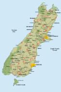
Queenstown New Zealand Map
 Editor for Asisbiz: Matthew Laird Acred
If you love our website Please donate so we can make this site even better !!
Please donate so we can make this site even better !!
