 |
 |
 |
 |
 |
 |
 |
 |
 |
 |
 |
 |
 |
 |
 |
 |
 |
 |
 |
 |
 |
 |
 |
 |
 |
 |
 |
 |
 |
 |
 |
 |
 |
 |
 |
 |
 |
 |
 |
 |
 |
 |
 |
 |
 |
 |
 |
 |
 |
 |
 |
 |
 |
 |
 |
 |
 |
 |
 |
 |
 |
 |
 |
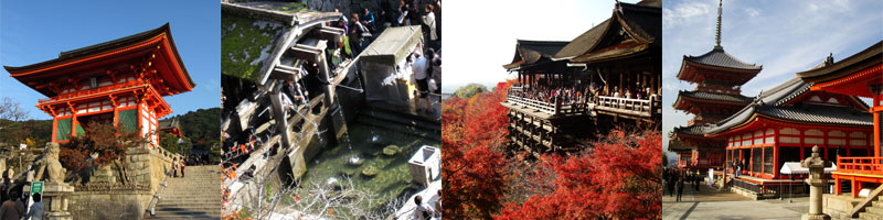
Kyoto (京都 Kyōto)
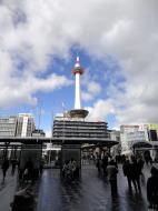
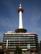
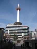
Kyoto Station (京都駅 Kyōto-eki)
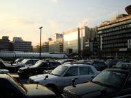
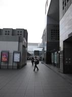
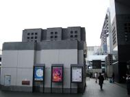
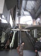
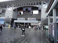
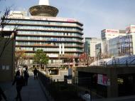
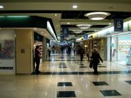
Kyoto Station (京都駅 Kyōto-eki) is the most important transportation hub in Kyoto, Japan. It has Japan's second-largest train station building (after Nagoya Station) and is one of the country's largest buildings, incorporating a shopping mall, hotel, movie theater, Isetan department store, and several local government facilities under one 15-story roof. It also housed the Kyoto City Air Terminal until August 31, 2002.
History
The first Kyoto Station opened for service by decree of Emperor Meiji on February 5, 1877. It was replaced by a newer, Renaissance-inspired facility in 1914, which featured a broad square leading from the station to Shichijo Avenue. Before and during World War II, the square was often used by imperial motorcades when Emperor Showa traveled between Kyoto and Tokyo: the image of Kyoto Station with its giant Rising Sun flags became a well-known image of the imperial era. This station burned to the ground in 1950 and was replaced by a more utilitarian concrete facility in 1952.
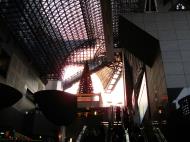
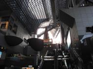
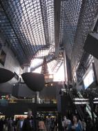
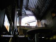
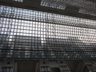
The current Kyoto Station opened in 1997, commemorating Kyoto's 1,200th anniversary. It is 70 meters high and 470 meters from east to west, with a total floor area of 238,000 square meters. Architecturally, it exhibits many characteristics of futurism, with a slightly irregular cubic facade of plate glass over a steel frame. The architect was Hiroshi Hara.
Kyoto, one of the least modern cities in Japan by virtue of its many cultural heritage sites, was largely reluctant to accept such an ambitious structure in the mid-1990s: The station's completion began a wave of new high-rise developments in the city that culminated with the 20-story Kyocera Building. For this, there are opinions criticizing the station design for taking part in breaking down the traditional cityscape.Aside from the main building on the north side of the station, the Hachijō-guchi building on the south side was built to house Tōkaidō Shinkansen which started operation in 1964. The underground facilities of the station, including the shopping mall Porta beneath the station square, was constructed when the subway opened in 1981.
Lines
Kyoto Station is served by the following railway lines:
Central Japan Railway Company (JR Central) Tōkaidō Shinkansen
West Japan Railway Company (JR West)
Tōkaidō Main Line (Biwako Line and JR Kyoto Line)
San'in Main Line (Sagano Line)
Nara Line
Kintetsu
Kyoto Line
Kyoto Municipal Subway
Karasuma Line
In addition to the lines above, the following lines, among others, have through services to Kyoto Station: JR West; Kosei Line; Kusatsu Line; JR West; JR CentralLayout
There is one side platform and four island platforms serving eight tracks for the Tōkaidō Line (Biwako Line, JR Kyoto Line) and Kosei Line at ground level, three dead-end platforms serving four tracks for the San'in Line (Sagano Line) to the west of platform 0 at ground level, and two dead-end platforms serving three tracks to the south of platform 7 at ground level. There are two island platforms serving four tracks for the Shinkansen, which are elevated.
Kyōto Station 京都駅
Main Entrance of Kyoto station
Location
Prefecture: Kyoto
8-3 Takakura-chō, Higashishio-kōji
Postal Code: 600-8214
(in Japanese): 京都市下京区東塩小路高倉町8-3
History
Year opened: 1877
Rail services
Operator(s): JR Central
JR West
Line(s): Tōkaidō Shinkansen (JR Central)
Biwako Line, JR Kyoto Line, Nara Line, Sagano Line (JR West)Web References:
http://upload.wikimedia.org/wikipedia/commons/4/41/JR_Kyoto_sta01nt3200.jpg
http://en.wikipedia.org/wiki/Kyoto_Station
http://en.wikipedia.org/wiki/Kyoto
Kyoto Prefecture (京都府, Kyōto-fu)
Kyoto Prefecture (京都府, Kyōto-fu) is a prefecture of Japan located in the Kansai region of the island of Honshū. The capital is the city of Kyoto.
History
For most of its history, the city of Kyoto was the Imperial capital of Japan. The history of the city itself can be traced back as far as the 6th century. In 544, the Aoi Matsuri was held in Kyoto to pray for good harvest and good weather.
Kyoto did not start out as the capital of Japan. A noteworthy earlier capital was Nara. In 741, Emperor Shōmu moved the capital briefly to a place called Kuni-kyo, between the cities of Nara and Kyoto, in present-day Kyoto Prefecture. In 784, the capital was moved to Nagaokakyō, also in present-day Kyoto Prefecture. In 794, Emperor Kammu moved the capital to Heian-kyo, and this was the beginning of the current-day city of Kyoto. Even today, almost all of the streets, houses, stores, temples and shrines in the city of Kyoto exist where they were placed in this year.
Although in 1192 real political power shifted to Kamakura, where a samurai clan established the shogunate, Kyoto still remained the imperial capital as the powerless emperors and their court continued to be seated in the city. Imperial rule was briefly restored in 1333, but another samurai clan established a new shogunate in Kyoto three years later.
In 1467, a great civil war, the Ōnin no Ran, took place inside Kyoto, and most of the town was burned down. Japan plunged into the age of warring feudal lords. A new strong man, Tokugawa Ieyasu, established the shogunate at Edo (today's Tokyo) in 1603.
The Meiji Restoration returned Japan to imperial rule in 1868. Emperor Meiji, who was now the absolute sovereign, went to stay in Tokyo during the next year. The imperial court has not returned to Kyoto since then. The subsequent reorganization of the old provincial system merged the former Tango Province, Yamashiro Province and the eastern part of Tanba Province into today's Kyoto Prefecture.
Although many Japanese major cities were heavily bombed by U.S. bombers during World War II, the old capital was escaped such devastating bombing. During the occupation, the U.S. Sixth Army was headquartered in Kyoto.
Geography
Kyoto Prefecture is located almost in the center of Honshū and of Japan. It covers an area of 4612.71 km², which is 1.2% of Japan. Kyoto is 31st by size. To the north, it faces the Sea of Japan and Fukui Prefecture. To the south, it faces Osaka and Nara Prefectures. To the east, it faces Mie and Shiga Prefectures. To the west, it faces Hyōgo Prefecture. The prefecture is separated in the middle by the Tanba Mountains. This makes its climate very different in the north and south.
Cities
Fifteen cities are located in Kyoto Prefecture.
* Ayabe * Fukuchiyama
* Jōyō
* Kameoka
* Kizugawa
* Kyōtanabe
* Kyōtango
* Kyoto (capital)
* Maizuru
* Miyazu
* Mukō
* Nagaokakyō
* Nantan
* Uji
* YawataTowns and villages
These are the towns and villages in each district:
* Funai District: Kyōtamba
* Kuse District: Kumiyama
* Otokuni District: Ōyamazaki
* Sōraku District: Kasagi, Minamiyamashiro, Seika, Wazuka
* Tsuzuki District: Ide, Ujitawara
* Yosa District: Ine, YosanoEconomy
The city of Kyoto is largely dependent on tourism. Northern Kyoto on the Tango Peninsula has fishing and water transportation, and midland Kyoto has agriculture and forestry. Nintendo is headquartered in the city of Kyoto.
Culture
Kyoto has been, and still remains to this day, the cultural center of Japan. For over 1000 years it was Japan's capital. When the capital was changed to Tokyo, Kyoto remained Japan's cultural capital.
Web References: http://en.wikipedia.org/wiki/Kyoto_Prefecture
Kyoto (京都 Kyōto), Japan Map
 Editor for Asisbiz: Matthew Laird Acred
If you love our website Please donate so we can make this site even better !!
Please donate so we can make this site even better !!
