
 |
 |
 |
 |
 |
 |
 |
 |
 |
 |
 |
 |
 |
 |
 |
 |
 |
 |
 |
 |
 |
 |
 |
 |
 |
 |
 |
 |
 |
 |
 |
Yosemite National Park
IUCN Category Ib (Wilderness Area)
Yosemite National Park
Location: Tuolumne, Mariposa, & Madera Counties, California, USA
Nearest city: Mariposa
Coordinates: 37°50′N 119°30′W / 37.833°N 119.5°W / 37.833; -119.5
Area: 761,266 acres (3,081 km²)
Established: October 1, 1890
Visitors: 3,242,644 (in 2006)
Governing body: National Park Service
World Heritage Site: 1984Yosemite National Park (pronounced yo-SEM-it-ee) is a national park located in the eastern portions of Tuolumne, Mariposa and Madera counties in east central California, United States. The park covers an area of 761,266 acres or 1,189 square miles (3,081 km²) and reaches across the western slopes of the Sierra Nevada mountain chain. Yosemite is visited by over 3.5 million people each year, many of whom only spend time in the seven square miles (18 km²) of Yosemite Valley. Designated a World Heritage Site in 1984, Yosemite is internationally recognized for its spectacular granite cliffs, waterfalls, clear streams, Giant Sequoia groves, and biological diversity. Almost 95% of the park is designated wilderness. Although not the first designated national park, Yosemite was a focal point in the development of the national park idea, largely owing to the work of people like John Muir and Galen Clark.
Yosemite is one of the largest and least fragmented habitat blocks in the Sierra Nevada, and the park supports a diversity of plants and animals. The park has an elevation range from 2,000 to 13,114 feet (600 to 4,000 m) and contains five major vegetation zones: chaparral/oak woodland, lower montane, upper montane, subalpine, and alpine. Of California's 7,000 plant species, about 50% occur in the Sierra Nevada and more than 20% within Yosemite. There is suitable habitat or documentation for more than 160 rare plants in the park, with rare local geologic formations and unique soils characterizing the restricted ranges many of these plants occupy.
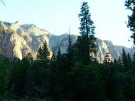
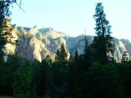
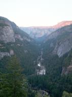
The geology of the Yosemite area is characterized by granitic rocks and remnants of older rock. About 10 million years ago, the Sierra Nevada was uplifted and then tilted to form its relatively gentle western slopes and the more dramatic eastern slopes. The uplift increased the steepness of stream and river beds, resulting in formation of deep, narrow canyons. About 1 million years ago, snow and ice accumulated, forming glaciers at the higher alpine meadows that moved down the river valleys. Ice thickness in Yosemite Valley may have reached 4,000 feet (1200 m) during the early glacial episode. The downslope movement of the ice masses cut and sculpted the U-shaped valley that attracts so many visitors to its scenic vistas today.
Geography
The exposed geology of the Yosemite area includes primarily granitic rocks with some older metamorphic rock. The first rocks were laid down in Precambrian times, when the area around Yosemite National Park was on the edge of a very young North American continent. The sediment that formed the area first settled in the waters of a shallow sea, and compressive forces from a subduction zone in the mid-Paleozoic fused the seabed rocks and sediments, appending them to the continent. Heat generated from the subduction created island arcs of volcanoes (not unlike Japan) that were also thrust into the area of the park. In time, the igneous and sedimentary rocks of the area were later heavily metamorphosed.
Most of the rock now exposed in the park is granitic, having been formed 210 to 80 million years ago as igneous diapirs 6 miles (10 km) below the surface. Over time, most of the overlying rock was uplifted along with the rest of the Sierra Nevadas and was removed from the area by erosion. This exposed the granitic rock to much lower pressure, and it was also subjected to erosion in the forms of exfoliation and mass wasting.
Starting about 3 million years ago a series of glaciations further modified the area by accelerating the erosion. During that time large glaciers periodically filled the valleys and canyons. Landslides and river erosion have been the primary erosive forces since the end of the last glacial period, which ended in this area around 10,000 BC.
Lower Cathedral Lake
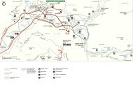
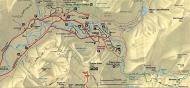
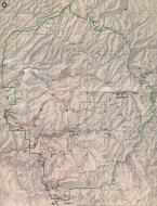
Yosemite National Park is located in the central Sierra Nevada of California. It takes approximately 3.5 hours to drive to the park from San Francisco and approximately 6 hours from Los Angeles. Yosemite is surrounded by wilderness areas: the Ansel Adams Wilderness to the southeast, the Hoover Wilderness to the northeast, and the Emigrant Wilderness to the north.
The 1,189 sq mi (3,081 km²) park is roughly the size of Rhode Island and contains thousands of lakes and ponds, 1,600 miles (2,600 km) of streams, 800 miles (1300 km) of hiking trails, and 350 miles (560 km) of roads. Two federally designated Wild and Scenic Rivers, the Merced and the Tuolumne, begin within Yosemite's borders and flow westward through the Sierra foothills, into the Central Valley of California. Annual park visitation exceeds 3.5 million, with most visitor use concentrated in the seven square mile (18 km²) area of Yosemite Valley.
Rocks and erosion
Almost all of the landforms in the Yosemite area are cut from the granitic rock of the Sierra Nevada Batholith (a batholith is a large mass of intrusive igneous rock that formed deep below the surface). About 5% of the park (mostly in its eastern margin near Mount Dana) are from metamorphosed volcanic and sedimentary rocks. These rocks are called roof pendants because they were once the roof of the underlying granitic rock.
Joint plane on Lembert Dome
Erosion acting upon different types of uplift-created joint and fracture systems is responsible for creating the valleys, canyons, domes, and other features we see today. These joints and fracture systems do not move, and are therefore not faults. Spacing between joints is controlled by the amount of silica in the granite and granodiorite rocks; more silica tends to create a more resistant rock, resulting in larger spaces between joints and fractures.
Pillars and columns, such as Washington Column and Lost Arrow, are created by cross joints. Erosion acting on master joints is responsible for creating valleys and later canyons. The single most erosive force over the last few million years has been large alpine glaciers, which have turned the previously V-shaped river-cut valleys into U-shaped glacial-cut canyons (such as Yosemite Valley and Hetch Hetchy Valley). Exfoliation (caused by the tendency of crystals in plutonic rocks to expand at the surface) acting on granitic rock with widely spaced joints is responsible for creating domes such as Half Dome and North Dome and inset arches like Royal Arches.
Popular features
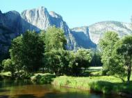
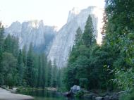
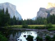
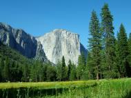
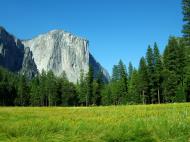
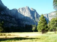
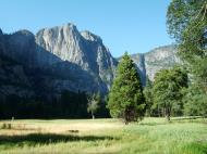
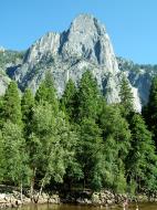
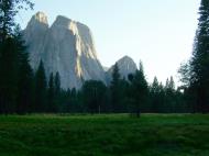
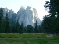
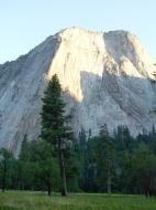
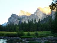
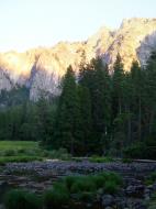
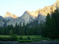
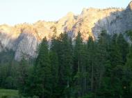
Yosemite Valley represents only one percent of the park area, but this is where most visitors arrive and stay. El Capitan, a prominent granite cliff that looms over the valley, is one of the most popular rock climbing destinations in the world because of its diverse range of climbing routes in addition to its year-round accessibility. Granite domes such as Sentinel Rock and Half Dome rise 3,000 feet and 4,800 feet (900 and 1,450 m), respectively, above the valley floor.
El CapitanThe high country of Yosemite contains beautiful areas such as Tuolumne Meadows, Dana Meadows, the Clark Range, the Cathedral Range, and the Kuna Crest. The Sierra crest and the Pacific Crest Trail run through Yosemite, with peaks of red metamorphic rock, such as Mount Dana and Mount Gibbs, and granite peaks, such as Mount Conness. Mount Lyell is the highest point in the park.
The park has three groves of ancient Giant Sequoia (Sequoiadendron giganteum) trees; the Mariposa Grove (200 trees), the Tuolumne Grove (25 trees), and the Merced Grove (20 trees). This species grows larger in volume than any other and is one of the tallest and longest-lived. These trees were much more widespread before the start of the last Ice Age.
Water and ice
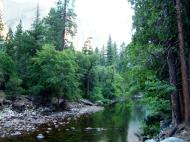
Tuolumne and Merced River systems originate along the crest of the Sierra Nevada in the park and have carved river canyons 3,000 to 4,000 feet (900 to 1,200 m) deep. The Tuolumne River drains the entire northern portion of the park, an area of approximately 680 square miles (1,760 km²). The Merced River begins in the park's southern peaks, primarily the Cathedral and Clark Ranges, and drains an area of approximately 511 square miles (1,320 km²).
Hydrologic processes, including glaciation, flooding, and fluvial geomorphic response, have been fundamental in creating landforms in the park. The park also contains approximately 3,200 lakes (greater than 100 m²), two reservoirs, and 1,700 miles (2,700 km) of streams, all of which help form these two large watersheds. Wetlands in Yosemite occur in valley bottoms throughout the park, and are often hydrologically linked to nearby lakes and rivers through seasonal flooding and groundwater movement. Meadow habitats, distributed at elevations from 3,000 to 11,000 feet (900 to 3,500 m) in the park, are generally wetlands, as are the riparian habitats found on the banks of Yosemite's numerous streams and rivers.
Yosemite is famous for its high concentration of waterfalls in a small area. Numerous sheer drops, glacial steps and hanging valleys in the park provide many places for waterfalls to exist, especially during April, May, and June (the snowmelt season). Located in Yosemite Valley, the 2,425-foot-high (739 m) Yosemite Falls is the highest in North America. Also in the valley is the much lower volume Ribbon Falls, which has the highest single vertical drop, 1,612 feet (492 m). Perhaps the most prominent of the Yosemite waterfalls is Bridalveil Fall, which is the waterfall seen from the Tunnel View viewpoint at the east end of the Wawona Tunnel. Wapama Falls in Hetch Hetchy Valley is another notable waterfall. Hundreds of ephemeral waterfalls also exist in the park.
All glaciers in the park are relatively small glaciers that occupy areas that are in almost permanent shade, such as north- and northeast-facing cirques. Lyell Glacier is the largest glacier in the Sierra Nevada (and therefore the park) and covers 160 acres (65 ha). None of the Yosemite glaciers are a remnant of the much, much larger Ice Age alpine glaciers responsible for sculpting the Yosemite landscape. Instead, they were formed during one of the neoglacial episodes that have occurred since the thawing of the Ice Age (such as the Little Ice Age). Global warming has reduced the number and size of glaciers around the world. Many Yosemite glaciers, including Merced Glacier, which was discovered by John Muir in 1871 and bolstered his glacial origins theory of the Yosemite area, have disappeared and most of the others have lost up to 75% of their surface area.
Climate
Yosemite has a Mediterranean climate, meaning most precipitation falls during the mild winter, and the other seasons are nearly dry (less than 3% of precipitation falls during the long, hot summers). Due to orographic lift, precipitation increases with elevation up to 8,000 feet (2,400 m) where it slowly decreases to the crest. Precipitation amounts vary from 36 inches (915 mm) at 4,000 feet (1,200 m) elevation to 50 inches (1,200 mm) at 8,600 feet (2,600 m). Snow does not typically persist on the ground until November in the high country. It accumulates all winter and into March or early April.
Temperature decreases with increasing elevation. Temperature extremes are moderated by the fact that Yosemite is only about 100 miles (160 km) from the Pacific Ocean. An anticyclone sits off the coast of California in the summer, sending cool air masses toward the Sierra Nevada that result in clean dry air in the Yosemite area.
Mean daily temperatures range from 25 to 53 °F (-3.9 to 11.5 °C) at Tuolumne Meadows at 8,600 feet (2,600 m). At the Wawona Entrance (elevation 5,130 feet; 1,564 m), mean daily temperature ranges from 36 to 67 °F (2.2 to 19.4 °C). At the lower elevations below 5,000 feet (1525 m), temperatures are hotter; the mean daily high temperature at Yosemite Valley (elevation 3,966 feet; 1,209 m) varies from 46 to 90 °F (7.8 to 32.2 °C). At elevations above 8,000 feet (2,440 m), the hot, dry summer temperatures are moderated by frequent summer thunderstorms, along with snow that can persist into July. The combination of dry vegetation, low relative humidity, and thunderstorms results in frequent lightning-caused fires as well.
At the park headquarters, normal January temperatures range from 47.2°F to 25.6°F and normal July temperatures range from 89.9°F to 53.2°F. There are an average of 47.7 days with highs of 90°F (32°C) or higher and an average of 137.5 days with lows of 32°F (0°C) or lower. Freezing temperatures have been recorded in every month of the year. The record high temperature was 115°F on July 20, 1915. The record low temperature was -6°F on January 2, 1924. Average annual precipitation is 36.57 inches; there an average of 69 days with measurable precipitation. The wettest year was 1983 with 68.94 inches and the dryest year was 1976 with 14.84 inches. The most precipitation in one month was 29.61 inches in December 1955 and the most in one day was 6.92 inches on December 23, 1955. Average annual snowfall is 65.6 inches. The snowiest year was 1967 with 154.9 inches. The most snow in one month was 140.8 inches in January 1993.
History
Paiute and Sierra Miwok peoples lived in the area for ages before the first white explorations into the region. A band of Native Americans called the Ahwahneechee lived in Yosemite Valley when the first non-indigenous people entered it.
The California Gold Rush in the mid-19th century dramatically increased white travel in the area. United States Army Major Jim Savage led the Mariposa Battalion into the west end of Yosemite Valley in 1851 while in pursuit of around 200 Ahwahneechees led by Chief Tenaya as part of the Mariposa Wars. Accounts from this battalion were the first confirmed cases of Caucasians entering the valley. Attached to Savage's unit was Dr. Lafayette Bunnell, the company physician, who later wrote about his awestruck impressions of the valley in The Discovery of the Yosemite. Bunnell is credited with naming the valley from his interviews with Chief Tenaya. Bunnell wrote that Chief Tenaya was the founder of the Pai-Ute Colony of Ah-wah-nee. The Miwoks (and most white settlers) considered the Ahwahneechee to be especially violent due to their frequent territorial disputes, and the Miwok word 'yohhe'meti' literally means 'they are killers'. Correspondence and articles written by members of the battalion helped to popularize the valley and surrounding area.
Tenaya and the rest of the Ahwahneechee were eventually captured and their village burned; they were removed to a reservation near Fresno, California. Some were later allowed to return to the valley, but got in trouble after attacking a group of eight gold miners in the spring of 1852. The band fled eastward to Mono Lake, and took refuge with the nearby Mono tribe; but after stealing some horses from their hosts, the Ahwahneechees were tracked down and killed by the Mono Paiutes in 1853. In the attack Chief Tenaya was killed and the survivors were taken back to Mono Lake and absorbed into the Mono Lake Paiute tribe. A reconstructed 'Indian Village of Ahwahnee' is now located behind the Yosemite Museum, which is next to the Yosemite Valley Visitor Center.
The Wawona Hotel
Entrepreneur James Mason Hutchings, artist Thomas Ayres and two others ventured into the area in 1855, becoming the valley's first tourists. Hutchings wrote articles and books about this and later excursions in the area, and Ayres' sketches became the first accurate drawings of many prominent features. Photographer Charles Leander Weed took the first photographs of the Valley's features in 1859. Later photographers included Ansel Adams.
Wawona was an Indian encampment in what is now the southwestern part of the park. Settler Galen Clark discovered the Mariposa Grove of Giant Sequoia in Wawona in 1857. Simple lodgings were built, as were roads to the area. In 1879, the Wawona Hotel was built to serve tourists visiting the Grove. As tourism increased, so did the number of trails and hotels.
Yosemite Grant
Concerned by the effects of commercial interests, prominent citizens including Galen Clark and Senator John Conness advocated for protection of the area. A park bill passed both houses of the U.S. Congress, and was signed by President Abraham Lincoln on June 30, 1864, creating the Yosemite Grant. This is the first instance of park land being set aside specifically for preservation and public use by action of the U.S. federal government, and set a precedent for the 1872 creation of Yellowstone as the first national park. Yosemite Valley and the Mariposa Grove were ceded to California as a state park, and a board of commissioners was proclaimed two years later.
Galen Clark
Galen Clark was appointed by the commission as the Grant's first guardian, but neither Clark nor the commissioners had the authority to evict homesteaders (which included Hutchings). The issue was not settled until 1875 when the homesteader land holdings were invalidated. Clark and the reigning commissioners were ousted in 1880, and Hutchings became the new park guardian.
Access to the park by tourists improved in the early years of the park, and conditions in the Valley were made more hospitable. Tourism significantly increased after the First Transcontinental Railroad was completed in 1869, but the long horseback ride to reach the area was a deterrent. Three stagecoach roads were built in the mid-1870s to provide better access for the growing number of visitors to the Valley.
Scottish-born naturalist John Muir wrote articles popularizing the area and increasing scientific interest in it. Muir was one of the first to theorize that the major landforms in Yosemite were created by large alpine glaciers, bucking established scientists such as Josiah Whitney, who regarded Muir as an amateur. Muir wrote scientific papers on the area's biology.
Increased protection efforts
Theodore Roosevelt and John Muir on Glacier PointOvergrazing of meadows (especially by sheep), logging of Giant Sequoia, and other damage caused Muir to become an advocate for further protection. Muir convinced prominent guests of the importance of putting the area under federal protection; one such guest was Robert Underwood Johnson, editor of Century Magazine. Muir and Johnson lobbied Congress for the Act that created Yosemite National Park on October 1, 1890. The State of California, however, retained control of the Valley and Grove. Muir also helped persuade local officials to virtually eliminate grazing from the Yosemite High Country.
Fallen Monarch and F Troop, 6th U.S. CavalryThe newly created national park came under the jurisdiction of the United States Army's Fourth Cavalry Regiment on May 19, 1891, which set up camp in Wawona. By the late 1890s, sheep grazing was no longer a problem, and the Army made many other improvements. The Cavalry could not intervene to help the worsening condition of the Valley or Grove.
Muir and his Sierra Club continued to lobby the government and influential people for the creation of a unified Yosemite National Park. In May 1903, President Theodore Roosevelt camped with Muir near Glacier Point for three days. On that trip, Muir convinced Roosevelt to take control of the Valley and the Grove away from California and return it to the federal government. In 1906, Roosevelt signed a bill that did precisely that.
National Park Service
The National Park Service was formed in 1916, and Yosemite was transferred to that agency's jurisdiction. Tuolumne Meadows Lodge, Tioga Pass Road, and campgrounds at Tenaya and Merced lakes were also completed in 1916. Automobiles started to enter the park in ever-increasing numbers following the construction of all-weather highways to the park. The Yosemite Museum was founded in 1926 through the efforts of Ansel Franklin Hall.
In 1903, a dam in the northern portion of the park was proposed. Located in the Hetch Hetchy Valley, its purpose was to provide water and hydroelectric power to San Francisco. Preservationists like Muir and his Sierra Club opposed the project, while conservationists like Gifford Pinchot supported it. In 1913, the U.S. Congress authorized the O'Shaughnessy Dam through passage of the Raker Act.
More recently, preservationists persuaded Congress to designate 677,600 acres (2,742 km²), or about 89% of the park, as the Yosemite Wilderness a highly protected wilderness area. The Park Service has reduced artificial inducements to visit the park, such as the Firefall, in which red-hot embers were pushed off a cliff near Glacier Point at night. Traffic congestion in Yosemite Valley during the summer months has become a concern. Plans to exclude all automobiles in the summer that are not registered at a hotel or campground within the valley have been investigated; this would put summer day-use visitors in the valley on a free shuttle bus system, on bicycles, or on foot.
Hotels and concessioners
In the early years of the park, different companies ran multiple hotels and resorts. These resorts included the Wawona Hotel, the Yosemite Park Lodge, and Camp Curry, a tent cabin site in Yosemite Valley. The Yosemite Park & Curry Company was formed in 1925 to consolidate those often-competing concessions. The Park Service granted the newly formed company exclusive right to operate hotels, restaurants and most stores in Yosemite. Two years later, the new company was headquartered on the mezzanine level of its new hotel, The Ahwahnee. The Yosemite Park and Curry Company ran the concessions in the park for over 50 years until the company was sold in the late 1970s to United States Natural Resources (USNR) and a couple of years later to MCA which operated Universal Studios. During those ownership changes, the Curry Company name continued. In 1993, MCA was acquired by Matsushita. Then Secretary of the Interior Manuel Lujan objected to a Japanese firm operating concessions in a U.S. national park, so to avoid delay of federal approval of the acquisition, Matsushita arranged for the sale of the concessions company, ownership of its concession properties was transferred to the federal government, and the Yosemite Park and Curry Co. name was retired. The park concession contract is now operated by Delaware North Companies 'Parks and Resorts' (the official concessionaire name in DNC Parks and Resorts at Yosemite, Inc.).
Geology
The area of the park was astride a passive continental margin during the Precambrian and early Paleozoic. Sediment was derived from continental sources and was deposited in shallow water. These rocks have since been metamorphosed.
Generalized geologic map of the Yosemite area (USGS image)Heat generated from the Farallon Plate subducting below the North American Plate led to the creation of an island arc of volcanoes on the west coast of proto-North America between the late Devonian and Permian periods. Later volcanism in the Jurassic intruded and covered these rocks in what may have been magmatic activity associated with the early stages of the creation of the Sierra Nevada Batholith. 95% of these rocks were eventually removed by uplifted-accelerated erosion.
The first phase of regional plutonism started 210 million years ago in the late Triassic and continued throughout the Jurassic to about 150 million years before present (BP). Around the same time, the Nevadan orogeny built the Nevadan mountain range (also called the Ancestral Sierra Nevada) to a height of 15,000 feet (4500 m). This was directly part of the creation of the Sierra Nevada Batholith, and the resulting rocks were mostly granitic in composition and emplaced about 6 miles (10 km) below the surface. The second major pluton emplacement phase lasted from about 120 million to 80 million years ago during the Cretaceous. This was part of the Sevier orogeny.
Starting 20 million years ago (in the Cenozoic) and lasting until 5 million years ago, a now-extinct extension of Cascade Range volcanoes erupted, bringing large amounts of igneous material in the area. These igneous deposits blanketed the region north of the Yosemite region. Volcanic activity persisted past 5 million years BP east of the current park borders in the Mono Lake and Long Valley areas.
Uplift and erosion
Starting 10 million years ago, vertical movement along the Sierra fault started to uplift the Sierra Nevada. Subsequent tilting of the Sierra block and the resulting accelerated uplift of the Sierra Nevada increased the gradient of western-flowing streams. The streams consequently ran faster and thus cut their valleys more quickly. Additional uplift occurred when major faults developed to the east, especially the creation of Owens Valley from Basin and Range-associated extensional forces. Uplift of the Sierra accelerated again about two million years ago during the Pleistocene.
The uplifting and increased erosion exposed granitic rocks in the area to surface pressures, resulting in exfoliation (responsible for the rounded shape of the many domes in the park) and mass wasting following the numerous fracture joint planes (cracks; especially vertical ones) in the now solidified plutons. Pleistocene glaciers further accelerated this process and the larger ones transported the resulting talus and till from valley floors.
Numerous vertical joint planes controlled where and how fast erosion took place. Most of these long, linear and very deep cracks trend northeast or northwest and form parallel, often regularly spaced sets. They were created by uplift-associated pressure release and by the unloading of overlying rock via erosion.
Sculpting by glaciers
A series of glaciations further modified the region starting about 2 to 3 million years ago and ending sometime around 10,000 BP. At least four major glaciations have occurred in the Sierra Nevada, locally called the Sherwin (also called the pre-Tahoe), Tahoe, Tenaya, and Tioga. The Sherwin glaciers were the largest, filling Yosemite and other valleys, while later stages produced much smaller glaciers. A Sherwin-age glacier was almost surely responsible for the major excavation and shaping of Yosemite Valley and other canyons in the area.
Glacial systems reached depths of up to 4000 feet (1200 m) and left their marks in the Yosemite area. The longest glacier in the Yosemite area ran down the Grand Canyon of the Tuolumne River for 60 miles (95 km), passing well beyond Hetch Hetchy Valley. Merced Glacier flowed out of Yosemite Valley and into the Merced River Gorge. Lee Vining Glacier carved Lee Vining Canyon and emptied into Lake Russel (the much-enlarged ice age version of Mono Lake). Only the highest peaks, such as Mount Dana and Mount Conness, were not covered by glaciers. Retreating glaciers often left recessional moraines that impounded lakes such as the 5.5 mile (8.9 km) long Lake Yosemite (a shallow lake that periodically covered much of the floor of Yosemite Valley).
Biology
Habitats
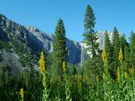
With its scrubby sun-baked chaparral, stately groves of pine, fir, and sequoia, and expanses of alpine woodlands and meadows, Yosemite National Park preserves a Sierra Nevada landscape as it prevailed before Euro-American settlement. In contrast to surrounding lands, which have been significantly altered by logging, the park still contains some 225,510 acres (912.6 km2) of old-growth forest. Taken together, the park's varied habitats support over 250 species of vertebrates, which include fish, amphibians, reptiles, birds, and mammals.
Along much of Yosemite's western boundary, habitats are dominated by mixed coniferous forests of Ponderosa Pine, Sugar Pine, Incense-cedar, White Fir, and Douglas Fir, and a few stands of Giant Sequoia, interspersed by areas of Black Oak and Canyon Live Oak. A relatively high diversity of wildlife species are supported by these habitats, due to relatively mild, lower-elevation climate and the mixture of habitat types and plant species. Wildlife species typically found in these habitats include American Black Bear, Bobcat, Gray Fox, Mule deer, Mountain Kingsnake, Gilbert's Skink, White-headed Woodpecker, Brown Creeper, Spotted Owl, and a wide variety of bat species. In the case of bats, large snags are important as roost sites.
Going higher in elevation, the coniferous forests become purer stands of Red Fir, Western White Pine, Jeffrey Pine, Lodgepole Pine, and the occasional Foxtail pine. Fewer wildlife species tend to be found in these habitats, due to their higher elevation and lower complexity. Species likely to be found include Golden-mantled Ground Squirrel, Chickaree, Fisher, Steller's Jay, Hermit Thrush, and Northern Goshawk. Reptiles are not common, but include Rubber Boa, western fence lizard, and Northern Alligator Lizard.
As the landscape rises, trees become smaller and more sparse, with stands broken by areas of exposed granite. These include Lodgepole Pine, Whitebark Pine, and Mountain Hemlock that, at highest elevations, give way to vast expanses of granite as treeline is reached. The climate in these habitats is harsh and the growing season is short, but species such as Pika, Yellow-bellied Marmot, White-tailed Jackrabbit, Clark's Nutcracker, and Rosy Finch are adapted to these conditions. Also, the treeless alpine habitats are the areas favored by Sierra Nevada Bighorn Sheep. This species, however, is now found in the Yosemite area only around Tioga Pass, where a small, reintroduced population exists.
At a variety of elevations, meadows provide important, productive habitat for wildlife. Animals come to feed on the green grasses and use the flowing and standing water found in many meadows. Predators, in turn, are attracted to these areas. The interface between meadow and forest is also favored by many animal species because of the proximity of open areas for foraging and cover for protection. Species that are highly dependent upon meadow habitat include Great Grey Owl, Willow Flycatcher, Yosemite Toad, and Mountain Beaver.
Management issues
Despite the richness of high-quality habitats in Yosemite, the California golden bear, California Condor, and Least Bell's Vireo have become extinct in the park within historical time, and another 37 species currently have special status under either California or federal endangered species legislation. The most serious current threats to Yosemite's wildlife and the ecosystems they occupy include loss of a natural fire regime, exotic species, air pollution, habitat fragmentation, and climate change. On a more local basis, factors such as road kills and the availability of human food have affected some wildlife species.
The black bears of Yosemite were once famous for breaking into parked cars to steal food. They were also an encouraged tourist sight for many years at the park's garbage dumps, where bears congregated to eat park visitors' garbage and tourists gathered to photograph the bears. Increasing encounters between bears and humans and increasing damage to property led to an aggressive campaign to discourage bears from relying on human food or interacting with people and their property. The open-air dumps were closed; all trash receptacles were replaced with bear-proof receptacles; all campgrounds were equipped with bear-proof food lockers so that people would not leave food in their vehicles, which were easy targets for the powerful and resourceful bears. Because bears who show aggression towards people usually are eventually destroyed, park personnel have continued to come up with innovative ways to have bears associate humans and their property with unpleasant experiences, such as being hit with rubber bullets. Today, about 30 bears a year are captured and ear-tagged and their DNA is sampled so that, when bear damage occurs, rangers can ascertain which bear is causing the problem.
Increasing ozone pollution is causing tissue damage to the massive Giant Sequoia trees in the park. This makes them more vulnerable to insect infestation and disease. Since the cones of these trees require fire-touched soil to germinate, historic fire suppression has reduced these trees' ability to reproduce. The current policy of setting prescribed fires is expected to help the germination issue.
Yosemite National Park has documented more than 130 non-native plant species within park boundaries. These non-native plants were introduced into Yosemite following the migration of early Euro-American settlers in the late 1850s. Natural and human-caused disturbances, such as wildland fires and construction activities, have contributed to a rapid increase in the spread of non-native plants. A number of these species aggressively invade and displace the native plant communities, resulting in impacts on the park's resources. Non-native plants can bring about significant changes in park ecosystems by altering the native plant communities and the processes that support them. Some non-native species may cause an increase in the fire frequency of an area or increase the available nitrogen in the soil that may allow more non-native plants to become established. Many non-native species, such as Yellow Star Thistle (Centaurea solstitialis), are able to produce a long tap root that allows them to out-compete the native plants for available water.
Bull Thistle (Cirsium vulgare), Common Mullein (Verbascum thapsus), and Klamath Weed (Hypericum perforatum) have been identified as noxious pests in Yosemite since the 1940s. Additional species that have been recognized more recently as aggressive and requiring control are Yellow Star Thistle, Sweet Clovers (Melilotus spp.), Himalayan Blackberry (Rubus discolor), Cut-leaved Blackberry (Rubus laciniatus) and Periwinkle (Vinca major).
Activities
Yosemite Valley is open year-round, but much of the remaining park is closed due to snow in late fall (autumn) and re-opens in mid to late spring. Open-air tours around Yosemite Valley and the Mariposa Grove of Giant Sequoias are available. Many people enjoy short walks and longer hikes to waterfalls in Yosemite Valley, or walks amongst Giant Sequoias in the Mariposa, Tuolumne, or Merced Groves. Others like to drive or take a tour bus to Glacier Point (summer-fall) to see a spectacular view of Yosemite Valley and the high country, or drive along the scenic Tioga Road to Tuolumne Meadows (summer-fall) and go for a walk or hike.
Most park visitors stay just for the day, and only visit locations within Yosemite Valley that are easily accessible by automobile. There is a US$20 per automobile user fee to enter the park. Traffic congestion in the valley is a serious problem during peak season, in summer. A free shuttle bus system operates year-round in the valley, and park rangers encourage people to use this system since parking within the valley during the summer is often nearly impossible to find.
In addition to exploring the natural features of the park, visitors can also learn about the natural and cultural history of Yosemite at a number of facilities in the valley: the Yosemite Valley Visitor Center, the adjoining Yosemite Museum, and the Nature Center at Happy Isles. There are also two National Historic Landmarks: the LeConte Memorial Lodge (Yosemite's first public visitor center), and the world-famous Ahwahnee Hotel. Camp 4 was added to the National Register of Historic Places in 2003.
Hiking
Over 800 miles (1300 km) of trails are available to hikers anything from the easy stroll, to the grueling hikes up several park mountains, to multiple-day backpack trips.
The park can be divided into 5 sections for the day-user—Yosemite Valley, Wawona/Mariposa Grove/ Glacier Point, Tuolumne Meadows, Hetch Hetchy, and Crane Flat/White Wolf. Numerous books describe park trails, and free information is available from the Park Service in Yosemite. Most park workers strongly encourage guests to experience portions of the park other than Yosemite Valley.
Between late spring and early fall, much of the park is open to multiple-day backpack trips. All overnight trips into the back country require a wilderness permit and most require approved bear-resistant food storage.
Biking
Bicycle rentals are available in Yosemite Valley spring through fall. Over 12 miles (19 km) of paved bike paths are available in Yosemite Valley. In addition, bicyclists can ride on regular roads. Helmets are required by law for children under 18 years of age. Off-trail riding and mountain biking are not permitted in Yosemite National Park.
Driving destinations
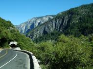
While some locations in Yosemite require hiking, other locations can be observed via automobile transportation. Driving locations also allow guests to observe the night sky in locations other than their campsite or lodge. All of the roads in Yosemite are scenic, but the most famous is the Tioga Road, typically open from late May or early June through November.
As an alternative to driving, bicycles are allowed on the roads. However, bicycles are only allowed off-road on 12 miles (19 km) of paved trails in Yosemite Valley itself; mountain biking is not allowed.
Climbing
Rock climbing is an important part of Yosemite. Camp 4—a walk-in campground in Yosemite Valley—was instrumental in the development of rock climbing as a sport, and is listed on the National Register of Historic Places. Climbers can generally be spotted in the snow-free months on anything from ten-foot-high (3 m) boulders to the 3,300 foot (1 km) face of El Capitan. Classes are offered by numerous groups on rock climbing.
Winter activities
Many of the roads in the park close due to heavy snow in winter; however, Yosemite Valley is open all year long. Downhill skiing is available at the Badger Pass Ski Area—the oldest downhill skiing area in California, offering downhill skiing from mid-December through early April. Much of the park is open to cross-country skiing and snowshoeing, with several backcountry ski huts open for use. Wilderness permits are required for backcountry overnight ski trips.
The Bracebridge dinner is an annual holiday event, held since 1927 at the Ahwahnee Hotel, inspired by Washington Irving's descriptions of Squire Bracebridge and English Christmas traditions of the 1700s in his Sketch Book. Between 1929 and 1973, the show was organized by Ansel Adams.
Web Reference: wikipedia.org - http://en.wikipedia.org/wiki/Yosemite_National_Park
Yosemite USA Map
 Editor for Asisbiz: Matthew Laird Acred
If you love our website Please donate so we can make this site even better !!
Please donate so we can make this site even better !!