|
 |
 |
 |
 |
 |
 |
 |
 |
 |
 |
 |
 |
 |
 |
 |
 |
 |
 |
 |
 |
 |
 |
 |
 |
 |
 |
 |
 |
 |
 |
 |
 |
 |
 |
 |
 |
 |
 |
 |
 |
 |
 |
 |
 |
 |
 |
 |
 |
 |
 |
 |
 |
 |
 |
 |
 |
 |
 |
 |
 |
 |
 |
 |
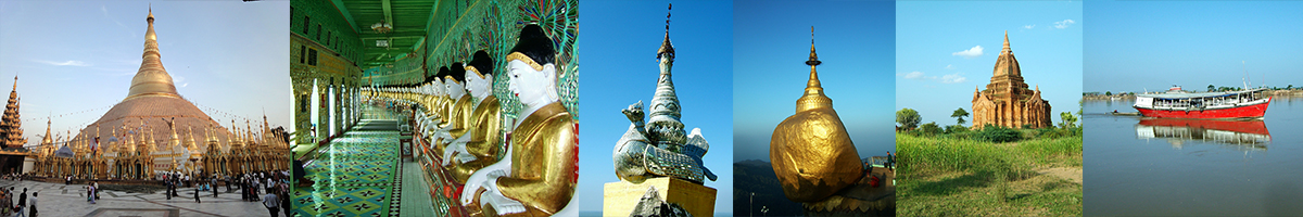
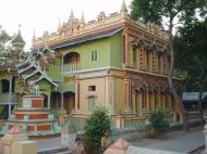
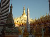
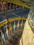
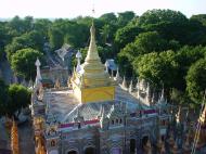
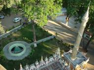
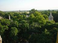
Thanboddhay Pagoda မိုးညှင်းသမ္ဗုဒ္ဓေ
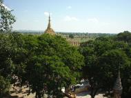
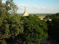
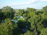
If you are travelling to Monwya by car you should stop about 20 kilometres before you reach the town to visit this most unusual Buddhist temple complex on 37 acres of land which is part of the Mohnyin Forest Monastery retreat. The pagoda was started on 20th June 1939 and completed on 2nd March 1952. It was the brain-child of the famous Mohnyin Sayadaw whose life-like effigy can be seen nearby.
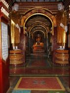
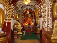
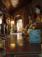
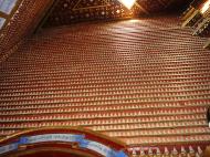
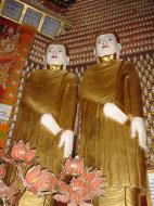
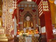
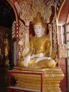
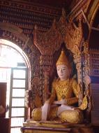
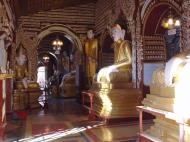
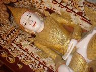
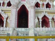
Some visitors say that this Pagoda reminds them of Borobodur, as it is similar in architectural design. Unlike Borobodur this is a modern place of worship, well maintained, and with interesting samples of modern Buddhist art. There are many different Buddha images, row upon row in ascending tiers in niches along the walls: the total number is 582, 257, an amazing figure! Unlike most of the pagodas in Myanmar, the entrance is not guarded by Chinthes, the mythical lions, but by statues of a pair of magnificant white elephants which are sacred and auspicious in Buddhist symbolism.
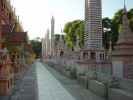
Thanboddhay is the only pagoda with this unique shape in the whole country. The square temple base (each side about 166 feet) which worshippers can enter is topped by receding terraces, with myriads of small stupas (864 in number) surrounding the central golden chedi, 132 feet in height.
Tourists can study and take photos of the twenty tagundaing, huge decorated pillars, and also big masonary fruits in the shape of bunches of bananas and coconuts, water melon, mangos, jackfruits, papaya and so on . These fruits are also objects of veneration for the local farmers.
If you can go at the beginning of the Myanmar month of Tazaungmone ( usually around November), you can see the annual pagoda festival, which goes on for several days when the villagers from all around come to enjoy the music and dancing, and buy from the various stalls set up by sellers from all over the country.
http://myanmartravelinformation.com/
Monywa
Monywa is a city in Sagaing Division, Myanmar, located 136 km northwest of Mandalay on the eastern bank of the River Chindwin.
Transport
It is served by the Mandalay-Budalin branch railway line, but is best reached by bus as the road from Mandalay is in reasonably good shape. Monywa is now linked by road to Budalin, Dabayin, Ye-U and Kin-U, and by rail to Sagaing and the Mandalay - Myitkyina line.[1] River transport on the Chindwin has always been important as it is navigable for 640 km (400 miles) up to Hkamti during the monsoon season, and most of the year to Homalin.Economy
Monywa is a major centre for trade and commerce and for agricultural produce from the surrounding Chindwin valley, especially beans, orange, pulses and jaggery (palm sugar). In addition, the local industry includes mills for the production of cotton, flour, noodles, and edible oils. Sausages from Alon called wet udaunk are quite popular, and Budalin longyi (sarong) is known for the strength of the fabric and its checked patterns. Monywa's rough cotton blankets are famous throughout Myanmar, and some can even be found sewn up into knapsacks sold to unsuspecting tourists in Bangkok. Other regional crafts include bamboo and reed products, bullock carts and agricultural implements. The village of Kyaukka is well known for its lacquerware utensils for everyday use.Black market goods from India, especially saris and bicycle parts, pass through Monywa on their way to other parts of Myanmar.The major tourist attraction in Monywa (although very few tourists make it there, and facilities are very limited) is Mohnyin Thambuddhei Paya, a Buddhist temple with a huge stupa resembling Indonesia's Borobudur. It dates from 1303, although it was reconstructed in 1939. It is said to contain over 500,000 images of Buddha.Education
The city is home to: Monywa UniversityPolitics
The insurgent Burmese Communist Party (BCP) was centred in the Monywa area (west of the Chindwin River) for many years. Although the BCP is no longer active, the Myanmar military presence in Monywa remains heavy.Sagaing Division
Sagaing Division is an administrative division of Myanmar, located in the north-western part of the country between latitude 21° 30' north and longitude 94° 97' east. It is bordered by India’s Nagaland and Manipur States to the north, Kachin State, Shan State, and Mandalay Division to the east, Mandalay Division and Magway Division to the south, with the Ayeyarwady River forming a greater part of its eastern and also southern boundary, and Chin State and India to the west. The division has an area of 93,527 km², and population (1996) of over 5,300,000. The capital is Sagaing.
Sagaing Division consists of 198 wards and villages, 38 townships and eight districts; Sagaing, Shwebo, Monywa, Katha, Kale, Tamu, Mawlaik and Hkamti. The major cities are Sagaing, Monywa, Shwebo, Katha, Kale, Tamu, Mawlaik and Hkamti. Mingunwith its famous bell is located near Sagaing but can be reached across the Ayeyarwady from Mandalay.
History
The Pyu were the first to in recorded history to populate the area of Sagaing Division by the 1st century CE. The Bamar (Burmans) first migrated into Upper Myanmar by 7th century CE. The area came under the Pagan Kingdom certainly by the middle of 11th century when King Anawrahta (r. 1044-1077) founded the Pagan Empire, which encompasses the modern day Myanmar.After the fall of Pagan in 1287, the northwestern parts of Upper Myanmar came under the Sagaing Kingdom (1315-1364) ruled by Burmanized Shan kings. The area was ruled by the kings of Ava from 1364 to 1555 and the kings of Taungoo from 1555 to 1752. Konbaung Dynasty (1752-1885), founded by king Alaungpaya in Shwebo, became the last Burmese dynasty before the British conquest of Upper Burma in 1885. The area became Sagaing Division after the Burmese independence in January 1948.
Demographics
Sagaing
The Bamar (Burmans) are the majority ethnic group in the dry regions and along the Mandalay-Myitkyina Railroad. Shan live in the upper Chindwin River valley. A sizable minority of Naga resides in the north of north-west mountain ranges and Chin in the south. Smaller ethnic groups native to the Division include the Kadu and Ganang, who live in the upper Mu River valley and Meza River valley.Economy
Agriculture is the chief occupation. The leading crop is rice, which occupies most of the arable ground. Other crops include wheat, sesame, peanut, pulses, cotton, and tobacco. Sagaing is Myanmar’s leading producer of wheat, contributing more than 80% of the country's total production. Forestry is important in the wetter upper regions along the Chindwin River, with teak and other hardwoods extracted. As in other parts of the country, reforestation is not effective enough to maintain sustainable forestry. Important minerals include gold, coal, salt and small amounts of petroleum. Industry includes textiles, copper refining, gold smelting, and a diesel engine plant. The Division has many rice mills, edible oil mills, saw mills, cotton mills, and mechanized weaving factories. Local industry includes earthen pots, silverware, bronze-wares, iron-wares and lacquerware.
Web reference:
https://en.wikipedia.org/wiki/Sagaing_Division
Thanboddhay Pagoda မိုးညှင်းသမ္ဗုဒ္ဓေ, Myanmar (Burma) Map
 Editor for Asisbiz: Matthew Laird Acred
If you love our website Please donate so we can make this site even better !!
Please donate so we can make this site even better !!